
Official websites use .gov
A .gov
website belongs to an official government organization in the
United States.
Secure .gov websites use HTTPS
A lock
(
) or https:// means you've safely
connected to the .gov website. Share sensitive information only
on official, secure websites.


Motorized Travel Management - Maps

General Locations of Travel Management Area Maps
Click on center of areas to download PDF map or see list of links below map.
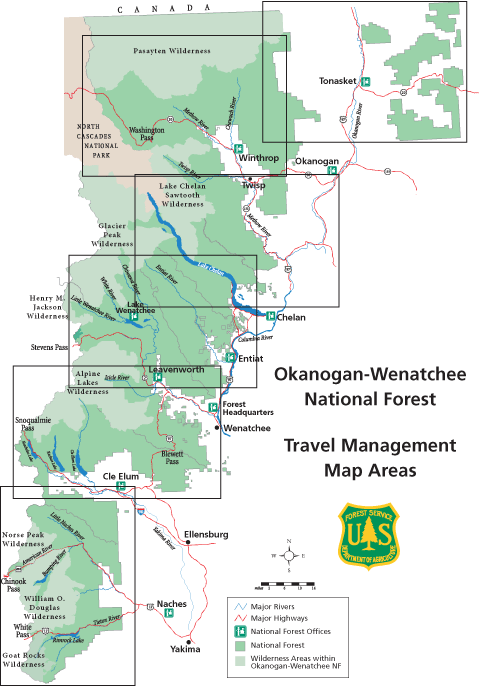
The links below are to the Proposed Action maps for each Ranger District area.
During the open house sessions and discussions it has become clear that communication about the Proposed Action could be improved with the use of maps showing all Forest Service system roads, irregardless of whether they are opened or closed. The following set of maps (noted with "all roads shown") displays the roads and trails proposed for motorized use by the Proposed Action Scoping Document and all other National Forest System roads that are not proposed for Motor vehicle use.
Printing and viewing note: Due to the large area, detail and size of the maps, zoom in on the area you want to see and use the "Print Current View" and "Fit to Page" options in the Acrobat print menu to print enlarged high quality sections of map.
Tonasket RD [PDF: 2.8 mb]
Tonasket RD with All Roads shown [PDF: 3.2 mb]North Methow Valley RD [PDF: 6 mb]
North Methow Valley RD with All Roads shown [PDF: 6.6 mb]South Methow Valley RD and North Chelan RD [PDF: 3 mb]
South Methow Valley RD and North Chelan RD with All Roads shown [PDF: 3.2 mb]North Wenatchee River RD, Entiat RD and South Chelan RD [PDF: 4 mb]
North Wenatchee River RD, Entiat RD and South Chelan RD with All Roads shown [PDF: 4.3 mb]South Wenatchee River RD and North Cle Elum RD [PDF: 4 mb]
South Wenatchee River RD and North Cle Elum RD with All Roads shown [PDF: 4.5 mb]South Cle Elum RD and Naches RD [PDF: 3.5 mb]
South Cle Elum RD and Naches RD with All Roads shown [PDF: 3.8 mb]