Official websites use .gov
A .gov
website belongs to an official government organization in the
United States.
Secure .gov websites use HTTPS
A lock
(
) or https:// means you've safely
connected to the .gov website. Share sensitive information only
on official, secure websites.


Maps & Publications
Forest Vicinity Map | Motor Vehicle Use Map | Publications
Forest Visitor Map

You can get the Oregon Central Coast Map (includes Siuslaw National Forest and BLM land) three ways:
- Visiting or contacting one of the Siuslaw National Forest offices
- Mailing your request with a check for $14.00 (make checks payable to: USDA Forest Service)
- Mail to: Siuslaw National Forest / PO Box 400 / Waldport, OR 97394
- Purchase and download a mobile friendly digital copy from Avenza (see details below).
Maps for Mobile Devices
Motor Vehicle Use Maps, recreation maps, and more detailed topographic maps for the Siuslaw National Forest are available through the Avenza Map Store. The Avenza Maps Application is free of charge and available for most Apple iPhone and Android Operating System products. The application can be downloaded directly to mobile devices through the iTunes store. The maps are geo-referenced and will work in conjunction with the GPS-enabled iPhone Operating System devices (iPhone 3GS and higher/ iPads with 3G/LTE). For more information on Avenza PDF maps, please refer to the Avenza website. There will be a charge for the Forest Visitor Maps, while Motor Vehicle Use Maps and others will be free of charge.
Trail Maps
We have geo-referenced PDF maps for all our trails. You can get them in one of two ways:
- Go to the specific trail or trailhead description page to find a link to the map covering that trail.
- Go to our mobile-friendly trail map download page
Maps and Publications Online
Forest Service Topography Maps: These maps show roads, trails, and campgrounds, on USGS's topographic maps. They are available for download by quadrangle.
National Forest Store: Offers a full, nationwide selection of National Forest, Ranger District, Wilderness, and Specialty Maps for purchase online or by phone, fax, and mail.
Discover Your Northwest: A nonprofit partner carrying a wide selection of maps, books, guides, and other interpretive products that highlight the Northwest’s natural and cultural history and support educational programs and services on public lands.
US Geological Survey (USGS): The national source to find, order, or download topographic maps, including quadrangles or “quads.”
Motor Vehicle Use Map
The Siuslaw National Forest Motor Vehicle Use Map shows the National Forest System roads, National Forest System trails, and the areas on National Forest System lands in that are designated for motor vehicle use. The map also identifies the vehicle classes allowed on each route and in each area; and any seasonal restrictions that apply on those routes and in those areas. When traveling on the Siuslaw National Forest, it is the operator’s responsibility to drive cautiously and use a current Motor Vehicle Use Map (MVUM) that shows the National Forest System roads, trails, and the areas designated for motor vehicle use. Maintenance of designated roads and trails will depend on available resources, and many may receive little maintenance. By your participation, you voluntarily assume full responsibility for damages, risks, and dangers. View the Motor Vehicle Use Map
Oregon Dunes Designated Routes Maps
Designated motorized travel routes were established for the Oregon Dunes National Recreation Area in 2015. These interactive, GPS-enabled maps to help guide you on the designations. View the Riding Area Maps.
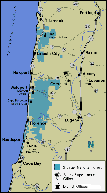
Forest Vicinity Map