
Official websites use .gov
A .gov
website belongs to an official government organization in the
United States.
Secure .gov websites use HTTPS
A lock
(
) or https:// means you've safely
connected to the .gov website. Share sensitive information only
on official, secure websites.


About the Area
About the Forest
The 1.83 million acre Rio Grande National Forest is located in southcentral Colorado and remains one of the true undiscovered jewels of Colorado.
The Rio Grande River begins its 1800 mile journey to the Gulf of Mexico high up in the San Juan Mountains in the western most part of the forest. The Continental Divide runs for 236 miles along most of the western border of the forest and the jagged tops of the Sangre de Cristo Mountains form the eastern border. In between these two mountain ranges sits the San Luis Valley, a large agricultural alpine valley. The Rio Grande National Forest is composed of a myriad of ecosystems ranging from high elevation desert at 7600 feet above sea level to rocky crags at over 14,300 feet in the Sangre de Cristo Mountains. Portions of four Wilderness Areas make up almost a fourth of the forest.
President Theodore Roosevelt established the Rio Grande National Forest by Presidential Proclamation in 1908. The Rio Grande, like others in the 191,000,000 acre National Forest System, is administered by the Forest Service, U.S. Department of Agriculture, for a variety of uses and values. The Multiple Use-Sustained Yield Act of 1960 directs that all National Forests be managed to provide wood products, high quality wildlife and fish habitat, good grazing for domestic livestock, recreation opportunities including wilderness, and pure water for domestic, industrial, and irrigation use. The Forest Service strives to maintain a balanced pattern of land use under the multiple use principle. In this manner, no single use dominates the Forest and the wide range of public and individual needs can be better met on a long-term basis.
• The RGNF is so named because the 1,800 mile long Rio Grande begins high up in San Juan Mountains in the western most portion of the Forest.
• The Rio Grande National Forest was established in 1908. Learn more about the history of the forest and the area.here.
• The Continental Divide runs for 236 miles along most of the western border of the Forest.
• Blanca Peak is the highest point on the Forest at 14,345 feet above sea level.
• The Forest contains a myriad of ecosystems; from pinyon pine and juniper dotted foothills to high elevation alpine tundra.
• The Forest surrounds the rural San Luis Valley, a large agricultural basin.
• Portions of four designated Wilderness areas (South San Juan, Weminuche, La Garita and Sangre de Cristo) are located within the RGNF.
• Temperatures during the summer peak out around 80 degrees and dip to well below zero during the winter.
• Some parts of the San Juan Mountains within the Forest average more than 400 inches of snowfall a year.
• The RGNF is located 3 1/2 hours south of Denver, CO and 3 ½ hours of north of Albuquerque, NM.
Seasonal Information
-
Spring

The mountains are still covered with a deep blanket of snow, while the south facing slopes of the foothills often begin to dry out in early April. Temperatures vary widely with the lows usually below freezing and the days are often windy with gusts reaching 30 mph or more.
-
Summer

The high elevations may hold large snow fields on north facing slopes well into July. July is also when the alpine wildflowers begin to bloom. They usually peak during the second half of the month. Temperatures may often reach well into the 80s in the lower elevations, but often peak out in the mid-70s above tree line. Monsoonal flows will often develop in July and bring afternoon thunderstorms to the mountains until late August.
-
Autumn
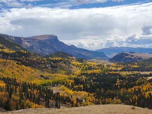
The first aspens begin to turn gold in early September, but generally the colors don’t peak until late in the third week of September in the Creede area and then a week or two later on the rest of the Forest. Every year is different and in some years, the fall can be quite mild with temperatures reaching the 70s during the day all the way into early October. Once the first heavy snow falls on the mountains (sometimes in October), the temperatures can bottom out in the single digits at night.
-
Winter

The San Juan Mountains in particular are famous for their deep snows. Wolf Creek Ski Area averages over 460 inches of snow a year. The light powder that often falls in December and January attracts skiers and snowboarders from around the world. Temperatures can be extremely cold in the San Luis Valley generally dropping below zero every clear night from mid-December to mid-February. The mountains actually tend to be a bit warmer than the Valley and day time temperatures will often hit the 20s, but feel much warmer than that on sunny days.
Recreation
From the Sangre de Cristo to the San Juan Mountains, the jagged peaks and rushing rivers of the San Luis Valley public lands wrap themselves around this Rocky Mountain basin. Whether viewing the mountain scenery from roads or finding challenge on trails, visitors discover solitude and self-reliance through uncrowded year-round recreation opportunities.
As you travel the National Forest, perhaps exploring "out of the way" places and historical sites, remember that the structures, buildings, and land are often privately owned. Please respect the rights and privacy of residents and, if in doubt about a particular site, check with the nearest District Ranger.
The Rio Grande National Forest has four Wilderness areas that provide scenery and solitude.