
Official websites use .gov
A .gov
website belongs to an official government organization in the
United States.
Secure .gov websites use HTTPS
A lock
(
) or https:// means you've safely
connected to the .gov website. Share sensitive information only
on official, secure websites.


East Fort Rock OHV Trail System
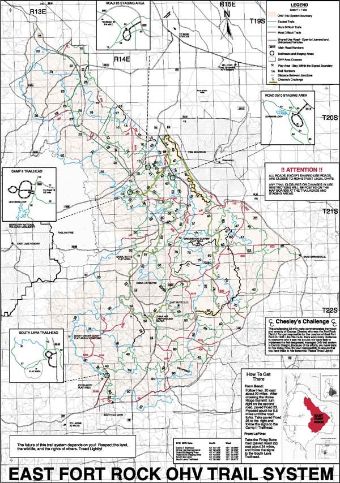
East Fort Rock OHV Trail Vicinity Map
 The East Fort Rock OHV trail system lies on the east side of the Bend/Fort Rock Ranger District of the Deschutes National Forest. Trails are well signed and mapped and provide a full range of difficulty from easiest to most difficult. There are four staging areas, a campground/staging area, and four designated play areas. It provides 318 miles of trails and 83 miles of shared use roads for casual and competitive use covering about 110,000 acres.
The trail system is designed for Class I (Quads, 3-wheelers less than 50" wide and 800 pounds) and Class III (motorcycles) ATVs. Class II vehicles (side by sides, jeeps, etc) are allowed on routes designated as shared use only. Non-street legal motorcycles and ATV's may ride on roads designated as Shared Use. All trails are open to horses, mountain bikes, and other recreationists, so please watch for others and share the trails.
These trails and facilities are operated and maintained for your enjoyment by Central Oregon Combined OHV Operations (a Forest Service, & Bureau of Land Management Cooperative agreement), Oregon Department of Parks and Recreation ATV Funds, support from Polaris T.R.A.I.L.S and Yamaha OHV Initiative grants, several user groups and many other volunteers.


At a Glance
| Fees: | No Fee |
|---|---|
| Permit Info: | Oregon State ATV Permit Required |
| Usage: | Heavy |
| Busiest Season: | April thru June, October, November |
| Restrictions: |
|
| Water: | No |
| Restroom: | Vault Toilets In All Staging Areas |
| Operated By: | Central Oregon OHV Operations for the Deschutes National Forest |
| Information Center: |
|
General Information
Directions:From Bend, follow Hwy 20 east about 20 miles. After crossing the Horse Ridge Summit, turn right on the second road, Spencer Well Road (paved Road 23). Proceed south for 5.5 miles until the road forks. Take the paved Road 25 to the right or the graveled Road 2510 to the left and follow the signs to the staging areas.
From La Pine, take the Finley Butte Road (paved Road 22) east about 24 miles and follow the signs to the South Lava Staging Area.
See also: Road 2510 Staging Area, 25 Staging Area, Camp II Staging Area, China Hat Campground, Ground Hog Rock Crawl and OHV Play Area, South Lava Staging Area.
General Notes:
Please check out our information to help make your trail riding experience more fulfilling and to learn how to Tread Lightly!
Activities
OHV Camping
Recreation areas with activity OHV Camping:Camping is permitted at all staging areas, as well as any existing dispersed camp within 300 feet of a road. All staging areas have information kiosks with trail maps and vault toilets. China Hat Staging Area/Campground has designated campsites.
Please restrict your campfires to established rings only. Please respect others and keep your riding to the trails.
- Water: The staging areas are primitive with no water.
- Garbage: There is no garbage collection so, please PACK IT OUT!
- Access to the staging areas all requires travel on gravel or dirt roads. The staging area closest to pavement is the 25 Staging Area but it is located on a dusty dirt road about 1/4 mile from road 25.
OHV Trail Riding
Recreation areas with activity OHV Trail Riding:The trail system is open all year, however hot, dusty conditions normally inhibit riding from mid July through September and cold, snowy conditions restrict riding from mid December through March.
About half of the trail system is within the Fox Butte Green Dot Area which restricts access to designated roads during the general deer hunting season. This is roughly a two week period from late September to mid October. Any roads or trails within this Green Dot area will be subject to the Green Dot restrictions.
Individual trails may be temporarily closed for maintenance or reconstruction or to provide resource protection. These trails are signed with orange posts and yellow signs. Please honor these closures as it reflects on the OHV community and impedes the maintenance of the trails.
All trails in East Fort Rock are two-way. Many of the trails are tight and narrow and are maintained in a manner to provide a primitive trail experience. Thus, there are numerous blind turns, other riders, hikers, horses or mountain bikes should be anticipated around every turn. Rocks and logs will be slippery when wet. Riding fast is hazardous and not recommended.
General Info:
Parking


Related Information
Highlights
Location