
Official websites use .gov
A .gov
website belongs to an official government organization in the
United States.
Secure .gov websites use HTTPS
A lock
(
) or https:// means you've safely
connected to the .gov website. Share sensitive information only
on official, secure websites.


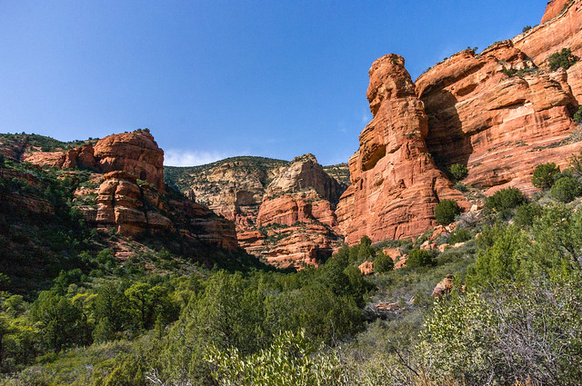
Fay Canyon Trail No. 53

Fay Canyon is a favorite hike for many who prefer a shorter hike with minimal elevation gain or who enjoy the grandeur of red sandstone walls towering overhead.
This small, hidden canyon supports a diverse community of desert plants and provides good views of the surrounding cliffs. It dead ends at a red Supai sandstone cliff. Throughout Fay Canyon you can marvel at the breathtaking scenery that surrounds you. Please be sure to practice "Leave No Trace" principles and stay on the designated trail.
At a Glance
| Open Season: | Year-round |
|---|---|
| Usage: | Medium |
| Closest Towns: | Sedona, AZ |
| Operated By: | Red Rock District - 928-203-2900 |
General Information
Directions:Location: 33 miles south of Flagstaff (2.5 miles west of Sedona) in scenic Red Rock Country on roads that are paved. Elevation is 4500 feet.
GPS (Map): 34°54'06.9"N 111°51'28.5"W
USGS Maps: Wilson Mountain
Access: Drive 27 miles south from Flagstaff to Sedona on US 89A. Continue through Sedona to Dry Creek Road (152C) at the west end of town. Turn north three miles to the Boynton Canyon intersection then left about a half mile to the Fay Canyon parking area on the left. Cross the street to the trailhead.
Click map thumbnail for larger view.

General Notes:
Length: 1.1 miles
Rating: Easy
Hiking time: 1 hour round trip
Notes: No mechanized vehicles (including mountain bikes) in Wilderness. This trail can be hot and dry in summer. Please do not disturb ruins or remove artifacts.
Activities
Day Hiking
Horse Riding

Related Information
Location

