
Official websites use .gov
A .gov
website belongs to an official government organization in the
United States.
Secure .gov websites use HTTPS
A lock
(
) or https:// means you've safely
connected to the .gov website. Share sensitive information only
on official, secure websites.


Little L.O. Trail No. 6

Little L.O. Trail is part of the Sycamore Canyon Wilderness Trail System.
Little L.O. Trail (Little Lookout Trail) branches off of Kelsey Trail not far from Babes Hole Spring and starts out with a gradual descent, then dives steeply into Sycamore Canyon and terminates at Sycamore Creek. The trail is mostly shady as it passes through ponderosa pine, Gambel oak, and juniper trees. Geronimo Spring is located where the trail meets Sycamore Creek and there is a good camp site located along the trail near the spring. Little L.O. Trail terminates at Sycamore Creek. Water is available at Kelsey Spring, Babes Hole Spring, and Geronimo Spring, which normally run all year.
Little L.O. Trail is often referred to as Geronimo Spring Trail, and sometimes Little Lookout Trail.
Hover mouse cursor over photo to display slideshow controls.
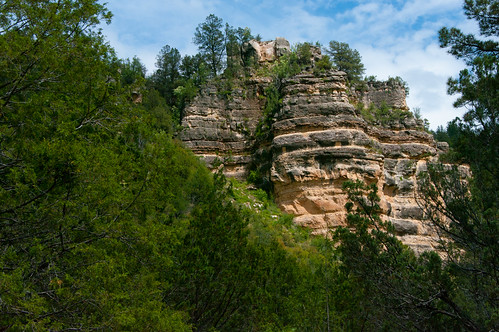
Photo tour from this trail [Flickr]
Sycamore Canyon is the second largest canyon in Arizona and offers hikers plenty of solitude and natural beauty. Learn more about Sycamore Canyon Wilderness.
Little L.O. Trail Statistics:
- Difficulty: Strenuous
- Length: 0.63 miles
- Trailhead Elevation: 6565 feet
- Elevation Gain/Loss: 863 feet
- Use: Hike, horse back
At a Glance
| Current Conditions: | Roads leading into the area are closed to vehicles during the winter season. |
|---|---|
| Usage: | Light |
| Best Season: | May to November |
| Closest Towns: | Flagstaff, AZ |
General Information
Directions:Location: Southwest of Flagstaff, Arizona
Access: From Flagstaff, take W. Old Route 66 west to FR 231 (Woody Mountain Road). Go south on FR 231 for 14 miles and take a right at FR 538 to FR 538G (about 5.5 miles). It's about 2 miles from junction of FR 538 and FR 538G to the trailhead. Kelsey Trailhead is about 1/4 mile west of the junction of FR 538G and FR 527A.
Access to the trailheads is by dirt roads which can be extremely rough and even impassable during Monsoon Season and winter months due to mud and heavy snow. Woody Mountain Road is subject to winter season road closure.
GPS:
- Kelsey Trailhead (Map): 35°04'28.3"N 111°55'47.1"W
- Babe Hole Spring (Map): 35°04'23.0"N 111°56'21.8"W
Maps
- Sycamore Canyon Wilderness Map: available from local Forest Service Offices
- Forest Service Topo Map (FSTopo Geo-enable PDF):
Click map thumbnail for a larger view.

General Notes:
Notes:
- No mechanized vehicles including bicycles in Wilderness.
- Fire danger is usually high - be careful with campfires.
- Camp at least 200 feet from springs and bury human waste 200 feet from springs - pack out all trash.
Leave No Trace: Recognize your role in preserving wild lands by practicing these Leave No Trace principles:
- Plan ahead and prepare.
- Travel and camp on durable surfaces.
- Dispose of waste properly.
- Leave what you find.
- Minimize campfire impacts.
- Respect wildlife.
- Be considerate of other visitors.