
Official websites use .gov
A .gov
website belongs to an official government organization in the
United States.
Secure .gov websites use HTTPS
A lock
(
) or https:// means you've safely
connected to the .gov website. Share sensitive information only
on official, secure websites.


Knoll Lake Campground
![[photo] Knoll Lake - Click for Larger view](/Internet/FSE_MEDIA/stelprdb5301075.jpg) This is a first-come, first-served secluded forest campground offering easy access to both Knoll Lake and the majestic Mogollon Rim.
This is a first-come, first-served secluded forest campground offering easy access to both Knoll Lake and the majestic Mogollon Rim.
The first is Knoll Lake, a medium-sized body of water tucked away in a picturesque setting. People come here to fish for trout and tour the lake in small boats.
The second feature of interest near this campground is the spectacular Mogollon Rim, a two thousand foot escarpment that marks the southern edge of the Colorado Plateau. This picturesque plunge from cool highlands to low deserts extends across most of Arizona. The area around Knoll Lake, however, is the home of some of the Rim's most magnificent views. It provides a scenic setting for hiking, mountain biking, horseback riding or just sitting back and enjoying the panorama.
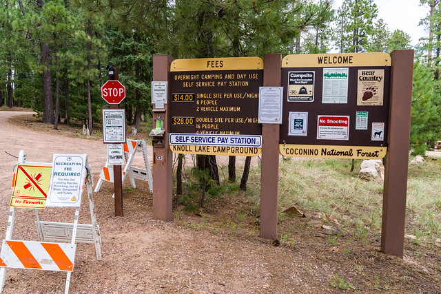
Group Campouts and Events: This campground does not have facilities for large groups or group activities. If one campsite cannot accommodate your group (eight at a single site, 16 at a double site), please call the Mogollon Rim Ranger District at 928-477-2255 to plan your group camp-out at Elks, Moqui, or Long Valley group campgrounds.
At a Glance
| Current Conditions: | First come, first served. |
|---|---|
| Reservations: | This is a first-come, first-served secluded forest campground offering easy access to both Knoll Lake and the majestic Mogollon Rim. |
| Area Amenities: | Boat ramp, Tent camping, Camping trailer, Picnic tables, Toilets, Drinking water, Parking |
| Fees: |
|
| Permit Info: |
|
| Open Season: | May - September |
| Usage: | Heavy |
| Restrictions: | Quiet hours: 10 p.m. to 6 a.m. (running generators not permitted during quiet hours) |
| Closest Towns: | Happy Jack, Arizona, and Strawberry, Arizona |
| Water: | Potable water available. |
| Restroom: | Vault Toilets |
| Operated By: | Mogollon Rim District - 928-477-2255 |
General Information
Directions:Location: About 80 miles southeast of Flagstaff. The elevation is 7,400 feet.
GPS (Map): 34°25'53.4"N 111°05'09.8"W
Access: Drive 55 miles south of Flagstaff to Clints Well on Forest Highway 3 (Lake Mary Road). Turn left (northeast) on to AZ 87, go about 10 miles to FR 95 which is just past the ranger station, turn right and drive 6 miles south to FR 96, turn left and travel 2 miles to FR 321. Turn right and drive 10 miles to FR 300. Turn east (left) and go 4 miles to FR 295E. Turn left again and drive to lake and campground.
Forest Highway 3 and AZ 87 are paved. All Forest Roads are graveled and suitable for sedans. FR 95 is closed during winter.
Click on image map thumbnail for larger view.

General Notes:
Attractions: Fishing, boating, hiking, sightseeing, wildlife viewing, and photography.
Notes:
- Cutting or chopping live trees is prohibited.
- Pets must always be restrained or on a leash.
- No horses allowed in the campground.
- Licensed off-road vehicles may be used only for entering or leaving campsite.
- 14 day stay limit.
Activities
Campground Camping
| No. of Sites | 30 single unit sites (up to 8 people and two vehicles) and 3 double sites (up to 16 people and four vehicles), tables, fire rings, cooking grills, and toilets (vault type). |
| Reservation Info | Not reservable |
Amenities
| Camping trailer: | RVs and trailers up to 32 feet. No utility hookups. |
|---|---|
| Picnic tables: | |
| Tent camping: | |
| Parking: | 2 vehicles per single site; 4 vehicles per double site. |
| Toilets: | |
| Boat ramp: | Campground is near Knoll Lake boat ramp. |
| Drinking water: | Yes |

Related Information
Location

