
Official websites use .gov
A .gov
website belongs to an official government organization in the
United States.
Secure .gov websites use HTTPS
A lock
(
) or https:// means you've safely
connected to the .gov website. Share sensitive information only
on official, secure websites.


Kachina Peaks Wilderness
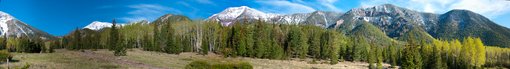
View of the San Francisco Peaks from the interior of extinct volcano's crater, the Inner Basin.
Here's a wilderness experience that takes you as high as you can get in Arizona. This 18,960 acre roadless area encompasses most of the upper reaches of the San Francisco Peaks including Humphreys Peak, Arizona's highest point at 12,643 feet. The area is named for the Hopi dieties, or Kachinas, whom that culture's mythology tells us live here for part of every year. In mid-summer these dieties fly from the top of the peaks to the Hopi mesas as clouds bringing the nourishing rains of the seasonal monsoons.
Not surprisingly, this most prominent feature on the northern Arizona landscape is sacred to all of the area's indigenous people and has become a source of awe and wonder to its more recently arrived visitors and residents as well.
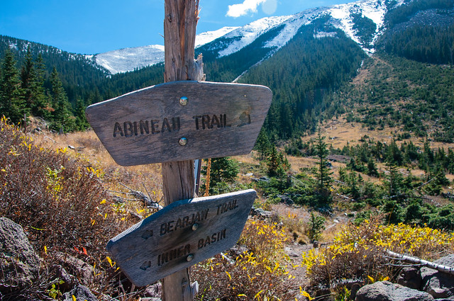
A number of trails offer access to this mountain which is a dormant volcano that last erupted roughly two million years ago. Some of those trails lead to the top of the several peaks which form the rim of the mountain's inner basin, a huge caldera which was formed during the mountain's most recent volcanic cataclysm. That once inhospitable crater now supports a thriving stand of white barked aspens and hardy mixed conifers. Other routes offer access to the forests and meadows which carpet the mountain's lower slopes. Views from any of these trails are well worth the effort of a visit.
At a Glance
| Current Conditions: | Some portions of this area are closed due to the Pipeline Fire Closure Order. |
|---|---|
| Usage: | Medium-Heavy |
| Best Season: | Summer Months |
| Restrictions: | Campfires are NOT allowed in this area. ATV use is NOT allowed in this area. |
| Closest Towns: | Flagstaff, AZ |
| Operated By: | Flagstaff Ranger District 928-526-0866 |
General Information
General Notes:Attractions: Wilderness solitude, Trails for hiking and horseback riding, Mountain scenery, Wildlife viewing, Fall colors
Notes:
- No mechanized or motorized equipment or vehicles, including bicycles, in the Wilderness.
- Hiking or camping off-trail above 11,400 feet is prohibited in order to protect the San Francisco Peaks Groundsel.
- There is no camping in the Inner Basin.
Trails in the Wilderness:
Slide Show: "Hiking the Kachina Peaks Wilderness Trails" Use left and right arrows for navagation. Use "Esc" key to exit.
Additional Resource: The Wilderness Institute (a non-Forest Service site)
Directions:
Location: 6 miles north of Flagstaff.
Access: Drive north from Flagstaff on U.S. 180 or U.S. 89. From U.S. 180, the Snowbowl Road and FR 418 and FR 420 provide access. From U. S. 89, FR's 418 and 420 provide access to lower slopes. FR 552 leads to Lockett Meadow and easiest access to the Inner Basin.
Click map image for printable view.

Activities
Day Hiking
Recreation areas with activity Day Hiking:- Abineau-Bear Jaw Loop
- Humphreys Trail No. 151
- Inner Basin Trail No. 29
- Kachina Trail No. 150
- Weatherford Trail No. 102


