
Official websites use .gov
A .gov
website belongs to an official government organization in the
United States.
Secure .gov websites use HTTPS
A lock
(
) or https:// means you've safely
connected to the .gov website. Share sensitive information only
on official, secure websites.


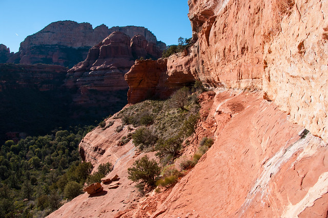
Boynton Canyon Trail No. 47

Boynton Canyon is one of the most scenic of the box canyons that make Arizona Red Rock Country so famous. This particular trail enjoys the additional advantage of being conveniently accessible to nearby towns on well paved roads. As you might suspect, that is both good and bad news for those who choose to come here. The good news is you don't have to bounce down a dusty jeep track to get to the trailhead. The bad news is you may have more company than you hoped for when you arrive.
Boynton Canyon always has been popular for its outstanding scenery. Lately it has become even more so, since it developed a reputation as a site of a spiritual energy vortex. Whether or not you follow this belief, you'll no doubt agree the beauty found among these towering buttes, crimson cliffs, and natural desert gardens is divine.
The trail starts out by skirting a luxury resort that was recently built here. It quickly returns to the canyon floor where the walking is pleasant and easy. As you hike, take note of the variety of plants that live in this rather harsh environment, and keep an eye out for the area's plentiful wildlife which includes everything from colorful songbirds to bristling, shy whitetail deer.
See also: Deadmans Pass Trail and Long Canyon Trail.
At a Glance
| Area Amenities: | Toilets |
|---|---|
| Open Season: | Year-round |
| Usage: | Heavy |
| Closest Towns: | Sedona, AZ |
| Restroom: | Vault Toilet at Trailhead |
| Passes: | Red Rock Pass or America the Beautiful Pass required to park at the trailhead. |
| Operated By: | Red Rock Ranger District - 928-203-2900 |
General Information
General Notes:Rating: Easy
Hiking time: 2-2.5 hours
Notes:
- No mechanized vehicles in Wilderness.
- Respect private property boundaries.
Directions:
Location: 32 miles south of Flagstaff (2 miles west of Sedona) on paved roads.
GPS (Map): 34°54'28.1"N 111°50'56.6"W
Maps
- Red Rock Country Maps: Download Red Rock Country trail maps and find other Sedona recreation resources. See the Sedona Northwest map for this trail.
- Forest Service Topo Map (FSTopo Geo-enable PDF):
Access: Drive 27 miles south from Flagstaff to Sedona on US 89A. Continue through Sedona to Dry Creek Road at the southwest end of town. Turn north (right) on Dry Creek Road and follow the signs to Boynton Canyon. You'll find a parking lot and the trailhead just outside the entrance to the Enchantment Resort.
Click map thumbnail for a larger view.

Parking:
The parking lot is paved with a vault-type toilet.
Activities
Day Hiking
Amenities
| Toilets: | Available at the trailhead |
|---|

Related Information
Location

