
Official websites use .gov
A .gov
website belongs to an official government organization in the
United States.
Secure .gov websites use HTTPS
A lock
(
) or https:// means you've safely
connected to the .gov website. Share sensitive information only
on official, secure websites.


Parsons Trail No. 144
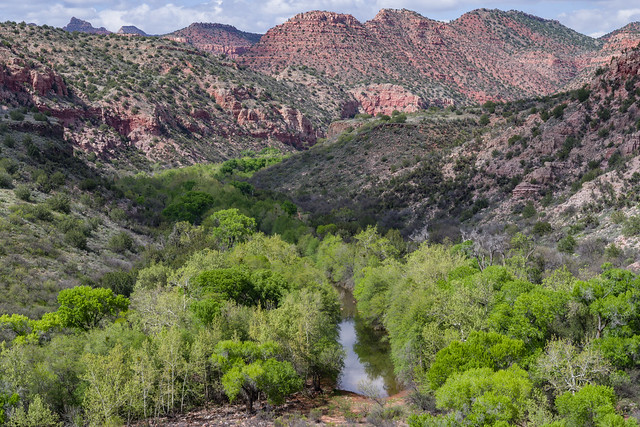
The hike up the Parsons Trail is a pleasant stroll along a cool, clear desert stream set in a magnificent red rock canyon. The trail leads through the lower reaches of this wilderness through a riparian area rich in plant and animal life. Songbirds flit through the tall cottonwoods and thick mesquite bosques. At a number of points additional springs flow from the canyon walls through gardens of columbine and watercress. Colorful cliffs that are a unique mix of dark columnar basalt, red sandstone, and buff colored limestone enclose the lush green of the oasis. The trail leads 4 miles to a large pool called Parson Springs where it surfaces from the underground course it has followed through the majority of the canyon. Up the canyon from the spring, water flow only occurs during snowmelt and after summer monsoons.
The steepest part of the trail is the descent from the trailhead, dropping several hundred feet to the canyon bottom. The rest of the trail is relatively easy in regards to slope. Prepare for multiple creek crossings on this trail, ranging from shoe-wetting to impassable depending on time of year, weather, and water flow. While refreshing in the summer and a welcomed challenge for those seeking a true wilderness experience, these crossings can be dangerous and flooding can be rapid and unexpected during rainy periods.
Wilderness areas are rare, wild places set aside by Congress where the land is allowed to retain its natural state, serving as a natural haven for humans to escape modern civilization and for nature to be itself. To help minimize human impacts in wilderness, motorized and mechanized equipment are prohibited by law, including bicycles, strollers, carts, and remote-control aircraft, and drones. We also ask that visitors practice Leave No Trace ethics.
This trail is part of the Sycamore Canyon Wilderness Southeast Trails. The lower, southern part of Sycamore Canyon Wilderness is managed by the Red Rock Ranger District.
At a Glance
| Current Conditions: | Notes: Camping/campfires within the first 3 miles of the trail is prohibited (see Forest Order 04-02-07-R for more details) Pets must be on-leash. Do not disturb cultural/archeology sites (Antiquities Act 1906). No motorized vehicles in the wilderness." |
|---|---|
| Usage: | Heavy |
| Closest Towns: | Clarkdale, AZ |
| Operated By: | Red Rock District - 928-203-2900 |
General Information
Directions:Location: 76 miles south of Flagstaff (33 miles south of Sedona) on paved and graveled roads.
Access: Drive 65 miles south from Flagstaff on US 89A through Sedona and Cottonwood to the turnoff to Tuzigoot National Monument. Turn north across the Verde River, then left on FR 131. It's about 11 miles to the trailhead.
GPS (Map): 34°51'50.7"N 112°04'11.0"W
Maps
- Sycamore Canyon Wilderness Map: available from local Forest Service Offices
- Forest Service Topo Map (FSTopo Geo-enable PDF):
Click map thumbnail for a larger view.

General Notes:
Rating: Easy
Hiking time: 5 hours round trip
Notes:
- No mechanized vehicles including bicycles in the Wilderness.
- Fire danger is usually high - be careful with campfires.
- Camp at least 200 feet from springs and bury human waste 200 feet from springs. Pack out all trash.
Leave No Trace: Recognize your role in preserving wild lands by practicing these Leave No Trace principles:
- Plan ahead and prepare.
- Travel and camp on durable surfaces.
- Dispose of waste properly.
- Leave what you find.
- Minimize campfire impacts.
- Respect wildlife.
- Be considerate of other visitors.
Activities
Day Hiking
Backpacking
Horse Riding
The Parsons Trailhead is a primary access for multi-day trips into Sycamore Canyon Wilderness when Sycamore Creek has water. Parsons Trail connects to Packard Mesa Trail on the Prescott National Forest for a 5 mile one-way ride. The trailhead is accessible by nearly all horse trailer sizes. Camping is not permitted at the trailhead.

Related Information
Location

