
Official websites use .gov
A .gov
website belongs to an official government organization in the
United States.
Secure .gov websites use HTTPS
A lock
(
) or https:// means you've safely
connected to the .gov website. Share sensitive information only
on official, secure websites.


Rollways Campground and Day Use Area
 Rollways Campground was built in 1909 and was one of the first campgrounds established on the Huron. The pull-through campsites accommodate large motor homes and trailers.
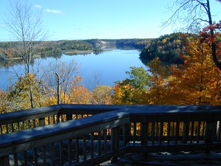
The day use area is adjacent to the Rollways Campground. A short, .5 hour walk between the day use site and Westgate Scenic Overlook provides visitors with access to the campground.
Brochure with map:
- River Road National Scenic Byway (pdf) - this brochure shows River Road, the Au Sable River and Lumberman's Monument
- Highbanks River Trail Map (coming soon)
- Eagle Run Trail Map (coming soon)
The brochure is set to print on 11 x 17 paper, landscape (wide) orientation. To print on 8 1/2 x 11 paper set the print area to "shrink to printable area", this will make the text on the page smaller. The trail maps are set to printon 8.5x11 paper.
Flickr Photo Albums:
At a Glance
| Operational Hours: | Open 24 hours a day, 7 days a week unless otherwise posted. Forest quiet hours apply. |
|---|---|
| Rentals & Guides: | Canoe Rentals -
|
| Fees: | Recreation Enhancement Act Fee - Camping -
|
| Permit Info: | Special Use Permit -
|
| Open Season: | May 5 - September 30 |
| Usage: | Light |
| Best Season: | May 15 to September 13 |
| Restrictions: | As a visitor to the National Forest, you are asked to follow certain rules designed to protect the Forest, natural resources and to provide for public safety of visitors. These rules are available to you on-line or at any office of the Huron-Manistee National Forests. Please take time to read and understand them. General Topic orders apply across the Forests. Applicable Orders -
|
| Closest Towns: | Hale, Glennie |
| Water: | Drinking Water |
| Restroom: | Vault |
| Operated By: | Huron Shores Ranger Station - (989) 739-0728 |
| Information Center: |
|
General Information
Directions:From Tawas-
- Travel west on M-55 for 14.7 miles.
- Turn right and travel north on M-65 for 14 miles.
- Turn left and travel north on Rollways Rd. for 500 ft.
- The site is located on the right.
From Oscoda -
- Travel west on River Rd. for 19 miles.
- Turn left and travel south on M-65 for 4.5 miles.
- Turn right and travel west on Rollways Rd. for 500 ft.
- The site is on the right.
General Notes:
Location - River Road National Scenic Byway, Au Sable River
Nearby Recreation Areas -
- Rollways Day Use Area
County - Iosco
Seasonal and Other Information -
- Gated when closed.
Accessibility:
- Accessible parking is available.
- Restroom facilities are accessible.
Activities
Campground Camping
| No. of Sites | Single: 19 |
| Reservation Info | 11 sites at Rollways Campground are reservable-
|
| Sleeping Shelter | No |
RV Camping
| No. of Sites | Single: 19 |
| Reservation Info | 11 sites at Rollways Campground are reservable-
|
| Pavement Type for Parking | Asphalt |
| Hookup - Water | No |
| Vehicle Clearence | Low |
| Hookup - Sewer | No |
| Size Restrictions | 50 Ft. or Less |
| Dump Stations | No |
| Hookups - Electric | No |
| Pavement Type of Parking | d |
River and Stream Fishing
| Fishing Mode | Boat, Shore, Wade |
| Fish Species | Bass, Pike, Brown Trout, Walleye, Perch, Sunfish, Steelhead, Salmon |
| Fishing Platform | No |
| Water Temperature | Cold |
| Fishing Method | Fly, Pole |
| Water/Flow Level | 2 mph |
Viewing Wildlife
Viewing Scenery
Several campsites have views of the river. Visitors who walk on the trail between the campground and Westgate Overlook will have several opportunities to view the Au Sable River.
Picnicking
The day use area has several picnic tables and a coverd pavilion with two fireplaces.
Ammenities:
- Trash can
- Picnic Shelter
- Fire Rings
- Pedestal Grills
- Benches
Group Picnicking
The day use area has several picnic tables and a coverd pavilion with two fireplaces.
Ammenities:
- Trash can
- Picnic Shelter
- Fire Rings
- Pedestal Grills
- Benches
| No. of Sites | 1 |
Boating - Non-Motorized
| Type of Craft | Canoe, Kayak |
| Size Restrictions | None |
| Class of Rapids | 0 |
Related Information
Location


