
Official websites use .gov
A .gov
website belongs to an official government organization in the
United States.
Secure .gov websites use HTTPS
A lock
(
) or https:// means you've safely
connected to the .gov website. Share sensitive information only
on official, secure websites.


Luzerne Horse Trail Campground and Trailhead
Area Status: Open
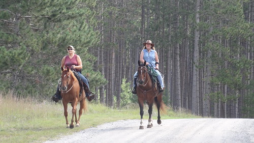
The parking lot is designed for trucks with horse trailers. This portion of trail features a unique cedar swamp ecosystem along the Big Creek/Luzerne boardwalk.
At a Glance
| Operational Hours: | Open 24 hours a day, 7 days a week unless otherwise posted. Forest quiet hours apply. |
|---|---|
| Area Amenities: | Parking |
| Fees: | No Fee |
| Permit Info: | Special Use Permit -
|
| Open Season: | April 1 - November 30 |
| Usage: | Light |
| Best Season: | April 1 to November 14 |
| Restrictions: | As a visitor to the National Forest, you are asked to follow certain rules designed to protect the Forest, natural resources and to provide for public safety of visitors. These rules are available to you on-line or at any office of the Huron-Manistee National Forests. Please take time to read and understand them. General Topic orders apply across the Forests. Applicable Orders -
|
| Closest Towns: | Luzerne |
| Water: | Not for Drinking |
| Restroom: | Vault |
| Operated By: | Mio Ranger District - (989) 826-3252 |
| Information Center: |
|
General Information
Directions:From Grayling -
- Travel east on M-72 for 22 miles.
- Turn right and travel south on Deeter Rd./CR-F490 for 2 miles.
- Turn left and travel south on Durfee Rd./FR 4551 for 1 mile.
- The site is located on the left.
General Notes:
Location - Michigan Shore to Shore Horse Trail
Nearby Recreation Areas -
- Huron OHV Trails
- Meadows ORV Trail System
- MCCCT
- Meadows ORV Campground
County - Oscoda
Seasonal and Other Information -
- This site is gated in the off season, but not closed:
- The Individual/Family camping area is open year-round.
- This site is not maintained in winter:
- Access road and/or parking not plowed.
- No water and/or toilet facilities available.
Activities
Campground Camping
Amenities -
- Picnic Table/Area
| No. of Sites | Single: 10 |
| Reservation Info | No reservation needed. All sites, are first come, first served. |
| Sleeping Shelter | No |
RV Camping
Amenities -
- Generator Driven Water Pump - 5,000 watt generator needed, generator not provided
- Picnic Table/Area
| No. of Sites |
|
| Reservation Info | No reservation needed. All sites are first come, first served. |
| Pavement Type for Parking | Dirt/Gravel |
| Hookup - Water | No |
| Vehicle Clearence | Low - Medium |
| Hookup - Sewer | No |
| Size Restrictions | 80 Ft. or Less |
| Dump Stations | No |
| Hookups - Electric | No |
Group Camping
Amenities -
- Generator Driven Water Pump - 5,000 watt generator needed, generator not provided
- Picnic Area/Shelter
| No. of Sites | Group: 1 (50 or more people) |
| Reservation Info | No reservation needed. All sites are first come, first served. |
| Group Shelter | No |
| Group Cooking Facilities | No |
| Hookups - Electric | No |
| Sleeping Shelter | No |
Day Hiking
Backpacking
Horse Camping
Amenities -
- Generator Driven Water Pump - 5,000 watt generator needed, generator not provided
- Picnic Table/Area
| No. of Sites |
|
| Reservation Info | No reservation needed. All sites are first come, first served. |
| Size Restrictions | No |
| Corrals | No |
| Loading Ramp | No |
| Watering Tank | Yes |
| Hitching Rails | No |
Horse Riding
XC Skiing/Snowshoeing
Amenities
| Parking: | 30 vehicle capacity - with trailers |
|---|
