
Official websites use .gov
A .gov
website belongs to an official government organization in the
United States.
Secure .gov websites use HTTPS
A lock
(
) or https:// means you've safely
connected to the .gov website. Share sensitive information only
on official, secure websites.


Little O ATV Trail
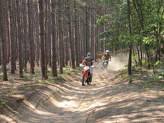
The trail traverses flat to rolling hills and goes through areas ranging from heavily forested with oak, maple and pine with a shrub, grass and fern understory to open meadows. There are several bridge crossings along the route.
The Little "O" ATV Trail is a 41-mile loop for ORV's 50" or less in width. It connects with MI-DNRE trails at M-37 north of Wolf Lake and the M-37 Trialhead.
This trail is shown on the Huron-Manistee National Forests Motor Vehicle Use Map, available in the Maps and Publications section. Motorized vehicles may only be operated on designated roads, trails or areas open to that use, visitors should obtain a Motor Vehicle Use Map.
A map is also located on the MI-DNRE website.
At a Glance
| Area Amenities: | Toilets, Parking |
|---|---|
| Permit Info: | Special Use Permit -
|
| Open Season: | January 1 - December 31 |
| Usage: | Light |
| Best Season: | April 15 to November |
| Busiest Season: | April to November |
| Restrictions: | Allowed: ORV's 50" wide or less Prohibited: Non-Highway Legal Vehicles Over 50" Wide; Motorized Over-snow Vehicles; Any Motorized Vehicle Over 50" Wide; camping at trailheads As a visitor to the National Forest, you are asked to follow certain rules designed to protect the Forest, natural resources and to provide for public safety of visitors. These rules are available to you on-line or at any office of the Huron-Manistee National Forests. Applicable Orders -
|
| Closest Towns: | Baldwin |
| Operated By: | Baldwin White Cloud Ranger District - 650 N. Michigan Ave. PO Box D, Baldwin, MI 49304 |
| Information Center: |
|
General Information
Directions:From Baldwin -
32nd. St. Trailhead
- Travel north on M-37 for 2.5 miles.
- Turn left and travel west on 32nd St. for 2.5 miles.
- The road terminates at the trailhead.
M-37 Little "O" Trailhead
- Travel north on M-37 for 9.5 miles.
- The site is located on the left.
Parking:
32nd. St. Trailhead
- 22 vehicle capacity - with trailers
- 3 vehicle capacity - vehicles without trailers
M-37 Little "O" Trailhead
- 20 vehicle capcity - with trailers
General Notes:
Location - Baldwin, MCCCT
Nearby Recreation Areas -
- Pere Marquette River Area
- Bowman Bridge Campground
- Bowman Lake Campground
- Bowman Lake Semi-Primitive Nonmotorized Area
- Upper Branch Bridge
- North Country National Scenic Trail
- Timber Creek Campground
County - Lake
Seasonal and Other Information -
- Trailheads are not gated during the off season.
- Trailheads are not maintained in winter:
- Access roads and/or parking lots are not plowed.
- No toilet facilities are available.
Activities
OHV Trail Riding
This trail is graded.
| Staging Area | No |
| Loading Ramp | No |
Amenities
| Parking: | 2 Trailheads |
|---|---|
| Toilets: | 32nd. St. and M-37 Trailheads |
Related Information
Location
