
Official websites use .gov
A .gov
website belongs to an official government organization in the
United States.
Secure .gov websites use HTTPS
A lock
(
) or https:// means you've safely
connected to the .gov website. Share sensitive information only
on official, secure websites.


Sawdust Hole River Access
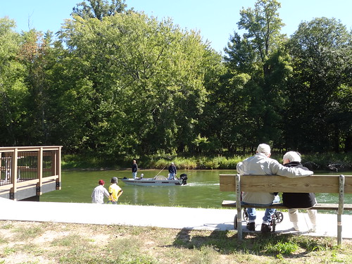
Lumber operations and river log drives of the 1800s abandoned many logs in the river. In the early 1900s salvage operations retrieved the abandoned logs which were then milled at the site. The original name of the site, Sawdust Pile, comes from the sawdust piles that used to be found near the sawmills. The sawdust flats were large open fields on the north side of the river were sawdust was piled until it was removed. There are multiple foot paths down to the river from the camping area. The North Country National Scenic Trail passes below and west of the site.
Brochure with map:
This brochure is set to print on 11 x 17 paper, landscape (wide) orientation. To print on 8 1/2 x 11 paper set the print area to "shrink to printable area", this will make the text on the page smaller.
Flickr Photo Albums
At a Glance
| Operational Hours: | Open 24 hours a day, 7 days a week unless otherwise posted. Forest quiet hours apply. |
|---|---|
| Fees: | Recreation Enhancement Act Fee - Day Use -
|
| Permit Info: | Special Use Permit -
|
| Open Season: | April 1 - November 30 |
| Usage: | Light |
| Best Season: | January 1 to December 31 |
| Busiest Season: | May to October |
| Restrictions: | As a visitor to the National Forest, you are asked to follow certain rules designed to protect the Forest, natural resources and to provide for public safety of visitors. These rules are available to you on-line or at any office of the Huron-Manistee National Forests. Please take time to read and understand them. General Topic orders apply across the Forests. Applicable Orders -
|
| Closest Towns: | Brethren |
| Water: | None |
| Restroom: | Vault |
| Operated By: | Cadillac/Manistee Ranger District - (231) 577-8902 |
| Information Center: | Cadillac/Manistee Ranger Station |
General Information
Directions:From Manistee -
- Travel east on M-55 for 15 miles.
- Turn left and travel north on High Bridge Rd. for 6 miles.
- Turn right and travel east on Coates Hwy. for 3.5 miles.
- Turn right and travel south on Dilling Rd. for 2 miles.
- Turn right and travel north on FR 8799 to the site entrance.
General Notes:
Location - Manistee National Recreation River
Nearby Recreation Areas -
- North Country National Scenic Trail
County - Manistee
Activities
Campground Camping
| No. of Sites | Single: 8 |
| Reservation Info | No reservation needed. All sites are first come, first served. |
River and Stream Fishing
| Fish Species | Salmon, Steelhead, Brook Trout, Brown Trout, Rainbow Trout, Walleye |
| Special Designations | National Recreation River |
| Fishing Mode | Boat, Shore Wade |
| Fishing Platform | No |
| Water Temperature | Cold |
| Fishing Method | Fly, Pole |
Day Hiking
This site is not a trailhead for the North Country National Scenic Trail but is located near the trail. Visitors are within a short driving and/or walking distance to the Dilling Rd. access.
Backpacking
This site is not a trailhead for the North Country National Scenic Trail but is located near the trail. Visitors are within a short driving and/or walking distance to the Dilling Rd. access.
Picnicking
| No. of Sites | 1 |
| Reservation Info | No reservation needed. All sites are first come, first served. |
Boating - Non-Motorized
| Type of Craft | Canoe, Kayak |
| Size Restrictions | None |
| Class of Rapids | 0 |
Related Information
Location


