
Official websites use .gov
A .gov
website belongs to an official government organization in the
United States.
Secure .gov websites use HTTPS
A lock
(
) or https:// means you've safely
connected to the .gov website. Share sensitive information only
on official, secure websites.


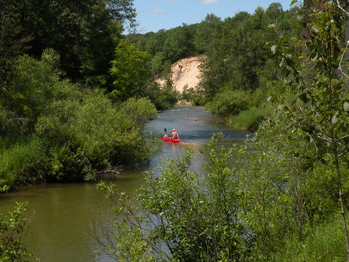
Dobson Bridge River Access
The parking lot is located at the top of a steep stairway. Visitors are asked to not disturb the wood turtles. There is a large patch of poison ivy near the water.
To download the Pine River, National Scenic River, brochure, with map, visit the Maps and Publications section of the website or select this link: http://www.fs.usda.gov/Internet/FSE_DOCUMENTS/stelprdb5172185.pdf. This brochure is set to print on 11 x 17 paper, landscape (wide) orientation. To print on 8 1/2 x 11 paper set the print area to "shrink to printable area", this will make the text on the page smaller.
Brochure and Map: This brochure is set to print on 11 x 17 paper, landscape (wide) orientation. To print on 8 1/2 x 11 paper set the print area to "shrink to printable area", this will make the text on the page smaller.
At a Glance
| Operational Hours: | Open 24 hours a day, 7 days a week unless otherwise posted. |
|---|---|
| Rentals & Guides: | Canoe Rentals -
|
| Area Amenities: | Boat ramp, Parking |
| Fees: | Recreation Enhancement Act Fee - Watercraft Permits -
|
| Permit Info: | Watercraft Permit -
|
| Open Season: | May 15 - November 30 |
| Usage: | Heavy |
| Best Season: | January 1 to December 31 |
| Restrictions: | As a visitor to the National Forest, you are asked to follow certain rules designed to protect the Forest, natural resources and to provide for public safety of visitors. These rules are available to you on-line or at any office of the Huron-Manistee National Forests. Please take time to read and understand them. General Topic orders apply across the Forests. Applicable Orders -
|
| Closest Towns: | Dublin |
| Water: | None |
| Restroom: | Vault |
| Operated By: | Cadillac Manistee Ranger District - (231) 577-8902 |
| Information Center: |
|
General Information
Directions:From Manistee -
- Travel east on M-55 for 26 miles.
- Turn right and travel south on M-37 for 2 miles.
- Turn left and travel west on 48 Mile Rd. for 2 miles.
- Keep right when the road becomes gravel.
- The entrance is on the left.
General Notes:
Location - Pine River, National Scenic River
Nearby Recreation Areas -
- Elm Flats
County - Wexford
Activities
River and Stream Fishing
| Fish Species | Brook Trout, Brown Trout, Rainbow Trout |
| Special Designations |
|
| Fishing Mode | Boat, Shore, Wade |
| Fishing Platform | No |
| Water Temperature | Cold |
| Fishing Method | Fly, Pole |
| Water/Flow Level | Fast |
Picnicking
Amenities -
- Pedestal grills
| No. of Sites | 2 |
| Reservation Info | No reservation is required for picnicking. A reservation is required for watercraft permits. |
Boating - Non-Motorized
Canoeing and kayaking are the primary activities on this river, with much of the appeal being the fast water and light rapids. The Pine River has a river gradient of 7% and offers the fastest average flow of any river in lower Michigan.
| Size Restrictions | None |
| Type of Craft | Canoe, Kayak, Pontoon, Raft, Driftboat |
| Class of Rapids | 1 - 2 |
| Water/Flow Level | Fast |
| Reservation required?: | Y |
|---|---|
| Permit required?: | Y |
Amenities
| Parking: | 30 vehicle capacity - with trailers |
|---|---|
| Boat ramp: | Wood, Gravel |
Related Information
Location


