
Official websites use .gov
A .gov
website belongs to an official government organization in the
United States.
Secure .gov websites use HTTPS
A lock
(
) or https:// means you've safely
connected to the .gov website. Share sensitive information only
on official, secure websites.


Smith Cr - Red Top Ridge Trail #21
The trailhead (elevation 4200 feet) is located 1 mile up Road #2446. The trail follows the old roadbed for 1/2 mile to a registration box for both Trails #21 and #347.
The trail leaves the roadbed here. It angles back up slope at a 10% grade then switchbacks again and continues at a gentle grade to junction with Trail #347 (elevation 4740 feet) at the 1 mile.
From here the trail continues to the 1 1/4 mile and the historic West Fork Cabin. The 14x16 foot cabin, situated at one end of a small meadow, was built in 1931 to house "smokechasers." In 1998 the cabin burned down and was rebuilt in 1999 to resemble the original cabin. This cabin is open to the public, but has seen heavy use over the years and should be treated with care to minimize impact.
The trail continues through big cedar spruce and alpine fir, alternating with more open, brushy areas at a gentle 10% grade. There are seasonal drainages crossed by wooden walkways along the trail.
At 2 3/4 mile the trail starts climbing toward a small saddle. The trail ends at the 3 1/4 mile and the junction with Trail #102 (elevation 5800 feet), with a view of Hidden Lake.
USGS Quad(s): Grass Mountain, Shorty Peak, Smith Peak
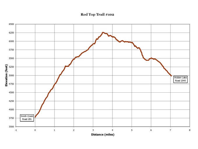
View an elevation profile of the trail.
View a more detailed map of the trail area.

At a Glance
| Restrictions: | Closed to motorized use. |
|---|---|
| Closest Towns: | Bonners Ferry, Idaho |
General Information
Directions:US 95 north of Bonners Ferry 15 miles to Copeland. Take the Copeland road west, across the Kootenai Valley, to Road 417. Turn right on Road 417 and continue north to its terminus, the junction with Roads 281 and 2450. Follow Road 281 to Road 2446. The trailhead is 1 mile up Road 2446. Turnaround constraints limit parking to 5 passenger vehicles. Stock vehicle parking on Road 281.
Activities
Day Hiking
This is a fairly easy hike accessing the historic West Fork Cabin and its small meadow. This cabin has seen heavy use since 1931 and should be treated with care to minimize impact. The trail also offers connections to the West Fork Lake area via Trail 347 and to Hidden Lake from its junction with Trail 102.| Difficulty Level: | Intermediate |
|---|
Backpacking
This is a fairly easy hike accessing the historic West Fork Cabin and its small meadow. This cabin has seen heavy use since 1931 and should be treated with care to minimize impact. The trail also offers connections to the West Fork Lake area via Trail 347 and to Hidden Lake from its junction with Trail 102.| Difficulty Level: | Intermediate |
|---|
Horse Riding
This is a fairly easy hike accessing the historic West Fork Cabin and its small meadow. This cabin has seen heavy use since 1931 and should be treated with care to minimize impact. The trail also offers connections to the West Fork Lake area via Trail 347 and to Hidden Lake from its junction with Trail 102.| Difficulty Level: | Intermediate |
|---|
Quick Links

Related Information
Location