
Official websites use .gov
A .gov
website belongs to an official government organization in the
United States.
Secure .gov websites use HTTPS
A lock
(
) or https:// means you've safely
connected to the .gov website. Share sensitive information only
on official, secure websites.


Red Top Trail #102
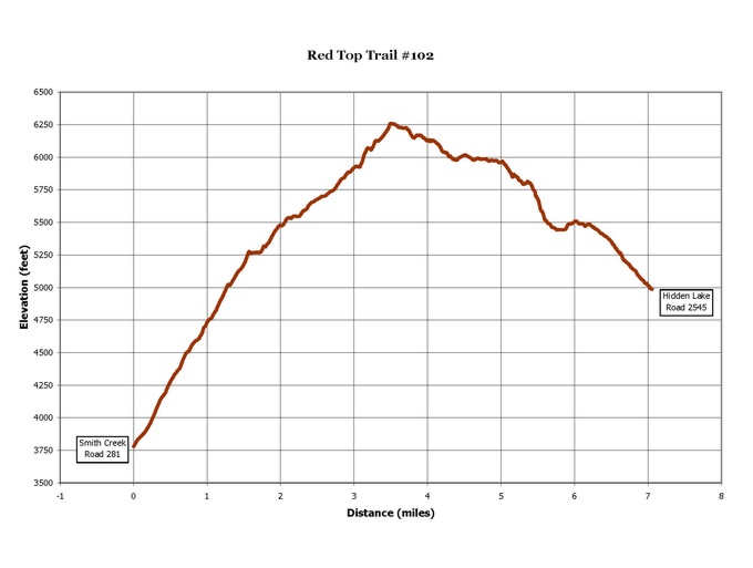
 The trail switchbacks through an old burn for the first .4 mile at about a 15% grade. It enters the woods at this point and sidehills at an almost level grade for another .5 mile and meets Hidden Lake at about the 1 mile. Fishing is good, and there are campsites available around the lake.
The trail to this point is rather easy hiking, but from here on becomes more rugged. The Red Top trail junctions with Trail #21, which leads to West Fork Cabin, at the north end of the lake. This portion of the trail is inaccessible until early July.
Trail #102 climbs for about 3 miles, with occasional steep, rocky stretches before reaching Red Top. There are remnants of an old lookout at the top, and spectacular views of the Selkirk Mountains and into Canada.
From here the trail begins a 4 mile descent to Road #281. It leaves the ridge and drops back into forested habitat with lots of huckleberry brush.
USGS Quad(s): Grass Mountain, Shorty Peak
View an elevation profile of the trail.
View a more detailed map of the trail area.

At a Glance
| Restrictions: | Closed to motorized use. |
|---|---|
| Closest Towns: | Bonners Ferry, Idaho |
General Information
Directions:#1: Travel north on US 95 from Bonners Ferry for 15 miles. Turn left onto Highway 1, and continue north for approximately 2 miles to Copeland Road (County Road 45). Turn left on Copeland Road, and follow it across Kootenai Valley to Westside Road #417. Turn right on Westside Road and continue north to Road #281. Turn left on Road #281, and follow it until the pavement turns to gravel. Continue straight on Road #655 for about 3½ miles, then bear left on Road #2545. Follow Road #2545 until it dead ends at the trailhead.
#2: Follow above instructions, but about 1 mile after gravel road #655 begins, bear left onto what becomes #281 again. Trailhead is just beyond stock vehicle parking area.
Trailhead #1: Room for 4-5 cars.
Trailhead #2: Park in turnouts at trailhead, stock vehicle parking area available shortly before trailhead.
Activities
Lake and Pond Fishing
A moderate hike of 1 mile accesses Hidden Lake, the largest alpine lake in the U.S. Selkirks. The lake usually offers good fishing. A steep bushwack up to Joe Peak offers a magnificent panorama of the mountains. The more serious hikers can follow Trail 102 to the old lookout site on Red Top or take Trail 21 from the junction over to West Fork Cabin.| Difficulty Level: | Intermediate |
|---|
Day Hiking
A moderate hike of 1 mile accesses Hidden Lake, the largest alpine lake in the U.S. Selkirks. The lake usually offers good fishing. A steep bushwack up to Joe Peak offers a magnificent panorama of the mountains. The more serious hikers can follow Trail 102 to the old lookout site on Red Top or take Trail 21 from the junction over to West Fork Cabin.| Difficulty Level: | Intermediate |
|---|
Backpacking
A moderate hike of 1 mile accesses Hidden Lake, the largest alpine lake in the U.S. Selkirks. The lake usually offers good fishing. A steep bushwack up to Joe Peak offers a magnificent panorama of the mountains. The more serious hikers can follow Trail 102 to the old lookout site on Red Top or take Trail 21 from the junction over to West Fork Cabin.| Difficulty Level: | Intermediate |
|---|
Horse Riding
A moderate hike of 1 mile accesses Hidden Lake, the largest alpine lake in the U.S. Selkirks. The lake usually offers good fishing. A steep bushwack up to Joe Peak offers a magnificent panorama of the mountains. The more serious hikers can follow Trail 102 to the old lookout site on Red Top or take Trail 21 from the junction over to West Fork Cabin.| Difficulty Level: | Intermediate |
|---|
Viewing Scenery
A moderate hike of 1 mile accesses Hidden Lake, the largest alpine lake in the U.S. Selkirks. The lake usually offers good fishing. A steep bushwack up to Joe Peak offers a magnificent panorama of the mountains. The more serious hikers can follow Trail 102 to the old lookout site on Red Top or take Trail 21 from the junction over to West Fork Cabin.| Difficulty Level: | Intermediate |
|---|
Quick Links

Related Information
Location