
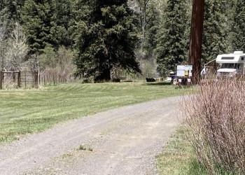
Blanco River Group Campground
The Blanco River Group Campground is a convenient stopping point between Chama, New Mexico, and Pagosa Springs, about 15 miles southeast of Pagosa Springs. This group campground offers one group site, accommodating up to 100 people but no individual sites. The river bottom area is fairly level, and 4 sites are suitable for large-sized RVs (max size = 35ft).
Several large ponderosa pines offer shade, but the area is quite warm in summer. This spot is quite a gem as visitors get a mile of river to themselves, along with 15 acres of forest fenced off to play and camp in. Anglers cast for stocked trout on the lightly fished waterway.
Amenities include trash pick-up, fire grates, horseshoe pits, and a volleyball court but campers must bring their own net and ball.


Reservations
Make Reservations HereGeneral Information
May through September. For specific open / closure dates, visit recreation.gov.
May - September
Overnight Use:
$140 per night
Maximum number of people per site: 8
Address: 180 Pagosa Street Pagosa Springs, CO 81147
Phone: (970) 264-2268
Hours: Monday-Friday, 8:00am-4:30pm (Closed on federal holidays)
Office Email: SM.FS.PagosaRD@usda.gov
Getting There
Latitude / Longitude
Latitude: 37.144887
Longitude: -106.883353
Directions
From Pagosa Springs, CO: Travel south on Highway 84 about 11.5 miles. Turn left onto Forest Rd. 656. Campgrond is located approximately 2 miles down FR 656.
Facility and Amenity Information
Restrooms
Restrooms are available at this site.
Water
Potable water is available at this site.
Picnic Tables
Picnic tables are available at this site.
Group campground includes picnic sites with have banquet-sized tables.
Horse/Pack Animal Information
Horse/Pack animals are not allowed at this site.
Recreation Opportunities
Fishing - River/Stream Info
Fishing the Blanco River: The river is stocked with trout and lightly fished, so fishing may be good.
Hiking Info
Trails: Three nearby trails access the roadless country to the east.
- Navajo Peak Trail and V-Rock Trail: Trailheads located on the Buckles Lake Road (Forest Development Road # 663), about seven miles south of the campground via Hwy. 84.
- Leche Creek Trail: Trailhead located off Blanco Basin Road (Forest Development Road # 657).