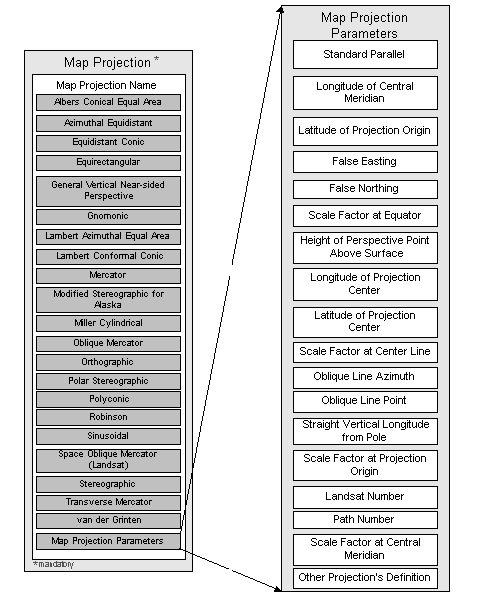
line of constant latitude at which the surface of the Earth and the plane or developable surface intersect. Note: can be entered once or twice as applicable
the line of longitude at the center of a map projection generally used as the basis for constructing the projection.
latitude chosen as the origin of rectangular coordinates for a map projection.
the value added to all "x" values in the rectangular coordinates for a map projection. This value frequently is assigned to eliminate negative numbers. Expressed in the unit of measure identified in Planar Coordinate Units.
the value added to all "y" values in the rectangular coordinates for a map projection. This value frequently is assigned to eliminate negative numbers. Expressed in the unit of measure identified in Planar Coordinate Units.
a multiplier for reducing a distance obtained from a map by computation or scaling to the actual distance along the equator.
height of viewpoint above the Earth, expressed in meters.
longitude of the point of projection for azimuthal projections.
a multiplier for reducing a distance obtained from a map by computation or scaling to the actual distance along the center line.
method used to describe the line along which an oblique mercator map projection is centered using the map projection origin and an azimuth.
method used to describe the line along which an oblique mercator map projection is centered using two points near the limits of the mapped region that define the center line.
longitude to be oriented straight up from the North or South Pole.
a multiplier for reducing a distance obtained from a map by computation or scaling to the actual distance at the projection origin.
number of the Landsat satellite. (Note: This data element exists solely to provide a parameter needed to define the space oblique mercator projection. It is not used to identify data originating from a remote sensing vehicle.)
number of the orbit of the Landsat satellite. (Note: This data element exists solely to provide a parameter needed to define the space oblique mercator projection. It is not used to identify data originating from a remote sensing vehicle.)
a multiplier for reducing a distance obtained from a map by computation or scaling to the actual distance along the central meridian.
a description of a projection, not defined elsewhere in the standard, that was used for the data set. The information provided shall include the name of the projection, names of parameters and values used for the data set, and the citation of the specification for the algorithms that describe the mathematical relationship between Earth and plane or developable surface for the projection.