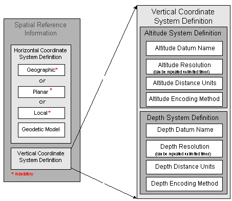
Altitude System Definition, mandatory if applicable
the reference frame or system from which altitudes (elevations) are measured. The term "altitude" is used instead of the common term "elevation" to conform to the terminology in Federal Information Processing Standards 70-1 and 173.
Note:The following elements comprise the Altitude System Definition:
the identification given to the surface taken as the surface of reference from which altitudes are measured.
the minimum distance possible between two adjacent altitude values, expressed in Altitude Distance Units of measure.
Note: can be repeated unlimited times
units in which altitudes are recorded.
the means used to encode the altitudes.
Depth System Definition, mandatory if applicable
the reference frame or system from which depths are measured.
Note:The following elements comprise the Depth System Definition:
the identification given to surface of reference from which depths are measured.
the minimum distance possible between two adjacent depth values, expressed in Depth Distance Units of measure.
Note: Depth Resolution must be greater than 0.0
units in which depths are recorded.
the means used to encode depths.