
Volume 34
Issue 2 | 2002
Issue 2 | 2002
|
|
||
| Privacy | Legal |
Volume 34
Issue 2 | 2002 |
|
|
|
||
Terri Anderson
Civil Engineer
Bitterroot National Forest
Hamilton, MT
Rodney Prellwitz, P.E.
Geotechnical Engineer
Bitterroot National Forest
Stevensville, MT
The McClain Creek Landslide is located on National Forest Service lands in the Bitterroot Mountains in the upper drainage area of McClain Creek. The landslide is more than one-half mile long and 200 feet wide (figure 1).
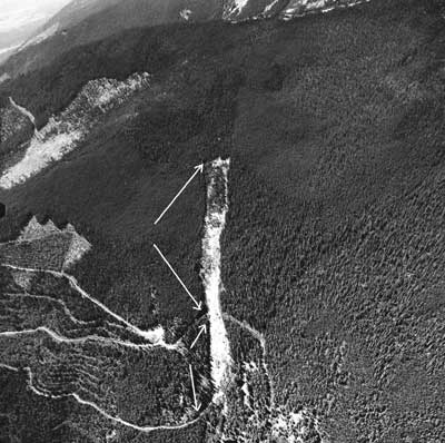
Figure 1. Aerial view of McClain Creek landslide.
A significant amount of the slide material consists of decomposed mica schist
and gneiss within a silty sand matrix. The mica schist has a plate-like structure
and a relatively low shear strength when saturated. Although the landslide may
have been reactivated by road construction in 1963, evidence of ancient landslide
activity exists within the current boundaries of the present slide. Previously
existing pressure ridges occur along both sides
of the landslide. These pressure ridges consist of material pushed up laterally
as the main slide mass moves downslope.
In 1994 a tort claim was filed against the Forest Service by adjacent landowners alleging damage to their property as a result of the McClain Creek landslide. The alleged damages included the deposition of sediment into the landowner's irrigation system. A settlement agreement was reached in November 1998 between the plaintiffs and the Forest Service. The Forest Service agreed to develop and execute a project to remove surface water from the landslide, revegetate the landslide surface area, and abate the heavy sedimentation flowing into McClain Creek and the landowner's irrigation system. The parties agreed that it would take through 2005 to evaluate the effectiveness of the project.
Geotechnical Investigations and Alternatives Considered
Prior to the settlement agreement in 1998, a seismic survey and reconnaissance
survey were conducted in 1978 and 1980, respectively. In 1994 a geotechnical
review by Landslide Technology (January 2, 1994) provided
the initial geotechnical evaluation by an outside source. Lynne Dickman, Bitterroot
NF geologist, documented a case history of the landslide.
In 1999 Aquoneering Inc., in conjunction with Womack & Associates, prepared a report for the U.S. Department of Justice (DOJ) to advise the DOJ and the Forest Service of potential alternatives to stabilize the slide. This report also included the first comprehensive field assessment of the hydrologic, hydraulic, and geotechnical aspects of the slide. Their basic plan involved the collection of surface and ground water from the top of the slide, then diverting it through lateral piping to the base of the slide. Directly below the toe of the slide, they proposed a sediment dam to collect sediment from the landslide.
 |
|||
|
|
|||
Visitor