

James Scott Groenier, Project Leader; Randy Foltz, Rocky Mountain Research Station;
and Charles Showers, Program Leader
Erosion needs to be controlled when roads are being constructed or decommissioned (removed), after lands have been burned by wildland fires, and when lands have been disturbed by other activities. This tech tip is the third in a series on using wood shreddings for erosion control. The first tech tip, Shredding Small Trees To Create Mulch for Erosion Control (0471–2335–MTDC, http://www.fs.fed.us/t-d/pubs/htmlpubs/htm04712335/index.htm) discussed the benefits of using wood shreddings rather than straw for erosion control, described three commercially available pieces of equipment that could manufacture shreddings, and presented information on a project that used wood shreddings to control erosion. The second tech tip, Using Rainfall Simulators To Test Wood Shreddings for Erosion Control (0571–2329P–MTDC, http://www.fs.fed.us/t-d/pubs/htmlpubs/htm05712329/index.htm) discussed testing shreddings using a rainfall simulator at the Rocky Mountain Research Station’s (RMRS) laboratory in Moscow, ID.
Highlights...
- When dirt roads on national forests are decommissioned (removed), the bare ground is exposed to erosion until vegetation becomes established.
- Research is underway to determine whether straw, WoodStraw (produced by Forest Concepts, LLC), or wood shreddings are more effective at controlling erosion.
- The Rocky Mountain Research Station will prepare a full research report based on 3 years of monitoring the amount of sedimentation eroded from test plots on a decommissioned road in the Payette National Forest, ID.
Monitoring Erosion After Road Decommissioning
The Payette National Forest in Idaho decommissions 20 to 45 miles of road per year. The forest has allowed a 3-year erosion control study to be conducted on Mud Creek Road, National Forest Road 051. The road was decommissioned (figure 1) and sites were chosen for four repetitions (each with four plots) treated with one of the three materials being tested: straw, WoodStraw (produced by Forest Concepts, LLC), and wood shreddings (figure 2). Erosion from the treated plots will be compared to erosion from plots with bare ground (figure 3) that are being used as controls. Each plot is about 600 square feet. The location of each treatment was chosen randomly. The plots are bordered by a collection system made from 22-gauge metal troughs fabricated at the RMRS laboratory in Moscow, ID. The troughs funnel water and sediment to a tank.

Figure 1—Mud Creek Road after it was decommissioned in the
Payette National Forest, ID.

Figure 2—A test plot covered with wood shreddings to
reduce erosion.

Figure 3—A plot with the bare ground exposed. Erosion on plots
with bare
ground will be compared to that on plots with erosion
control treatments.
Constructing Plots
Sites with similar properties were selected for the plots. The remainder of the decommissioned road was scattered with slash and seeded. The first step in constructing a plot was to lay out a 600-square-foot area and run a string line to mark the edges. Dirt and debris underneath the string line were cleared away and a trench was dug for the collection troughs. After the trench had been dug, a layer of bentonite was laid into the trench to provide a seal around the sections of metal trough (figure 4). Silicone caulking was applied to areas where the sections of trough overlapped (figure 5), each section was placed in the trench (figure 6), wooden stakes were driven to hold the troughs in place (figure 7), and the sections of trough were fastened to the wooden stakes with screws (figure 8). A tank collected water and sediment (figure 9) at the trough’s outlet. The tank has a drain hole and pipe to allow drainage.

Figure 4—Applying bentonite to seal the trench around the trough.

Figure 5—Applying silicone caulking to the trough’s
overlapping sections.
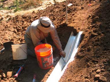
Figure 6—Placing a section of trough in the trench.

Figure 7—Driving the wooden stakes that hold the sections
of trough in place.

Figure 8—Screwing sections of trough to the wooden stakes.
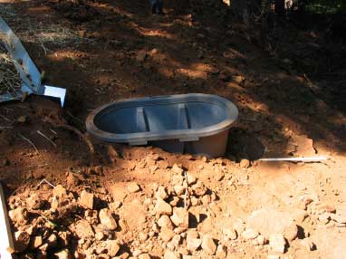
Figure 9—These tanks collect sediment and water from
the test plots.
Monitoring Plots
Erosion on the plots will be monitored for 3 years and the tanks will be checked for accumulated sediment. The plots will be checked in the spring after snowmelt (early May), before winter (late October), and after major rainfalls.
RMRS will prepare an indepth research paper on the study when the project is completed. For more information on the research project, contact Randy Foltz at RMRS, 208–883–2312 or e-mail: rfoltz@fs. fed.us.
About the Authors
James Scott Groenier, professional engineer, began working for MTDC as a project leader in 2003. Groenier earned a bachelor’s degree in civil and environmental engineering from the University of Wisconsin at Madison and a master’s degree in civil engineering from Montana State University. He worked for the Wisconsin and Illinois State Departments of Transportation and with an engineering consulting firm before joining the Forest Service in 1992. He worked as the east zone structural engineer for the Eastern Region and as a civil engineer for the Ashley and Tongass National Forests before coming to MTDC.
Randy Foltz is a research engineer with the Forest Service. His current research is on the environmental impact of forest road removal (road obliteration), the use of wood-based materials to reduce erosion, and the impacts of all-terrain vehicles on erosion and the infiltration of water into the soil. Other research topics have included the erodibility of road aggregates and the benefits of lowered tire pressure in reducing erosion from forest roads.
Charles Showers, professional engineer, became engineering program leader at MTDC in the spring of 2002 after serving 2 years as operations program leader. Showers came to MTDC after 9 years as assistant forest engineer on the Payette National Forest. He began his Forest Service career on the Boise National Forest after completing 8 years as a construction project engineer with the Idaho Transportation Department.
Single copies of this document may be ordered from:
USDA Forest Service, Missoula Technology and Development Center
5785 Hwy. 10 West; Missoula, MT 59808–9361
Phone: 406–329–3978; Fax: 406–329–3719
E-mail: wo_mtdc_pubs@fs.fed.us
Electronic copies of MTDC’s documents are available on the Internet at:
http://www.fs.fed.us/eng/pubs/
Forest Service and Bureau of Land Management employees can search a more complete collection of MTDC’s documents, CDs, DVDs and videos on their internal computer network at:
http://fsweb.mtdc.wo.fs.fed.us/search/
For additional information about using wood shreddings for erosion control, contact MTDC:
Phone: 406–329–3900; Fax: 406–329–3719
For additional information about the road decommissioning erosion control test, contact Randy Foltz at the RMRS Moscow Forestry Sciences Laboratory:
1221 South Main; Moscow, ID 83843
Phone: 208–883–2312; Fax: 208–883–2318
E-mail: rfoltz@fs.fed.us
For further information about road decommissioning on the Payette National Forest, contact Tom Crawford at the Payette National Forest: Phone:
208–634–0619; E-mail: tcrawford@fs.fed.us