
Types of Wetlands
- Wetlands Formed by Glacial Action
- Wetlands With Organic Silt and Clay Soils
- River Deposits and Deltas
- Floating Wetlands—Trembling Earth or Quaking Bog
- Wetlands on Mountains
- Spruce Bogs
- Muskeg
- Wetlands With Wildlife That Bite Back
Wetland managers and specialists recognize 30 or more different types of wetlands. From a trail construction view point, there are only six types of wetlands, perhaps seven. The basic differences in construction techniques for wetland trails depend greatly on the geologic, hydrologic, and vegetative factors influencing the site and, to a degree, on the wildlife species that live there.
Local indicator plants can help identify whether a site may be a wetland. Test holes and rod soundings can help determine the capability of the soil to support a trail. By studying the soil, the wildlife, and the subsurface water at the site, you can select the appropriate trail layout and construction techniques.
Wetlands Formed by Glacial Action
Generally, trails are easiest to construct in wetlands formed by glacial action. As a glacier melts, sand, gravel, boulders, and occasional blocks of ice are deposited in a narrow area in a mountain valley. The melting glacier creates a large creek or river that drains the valley. During spring runoff, adjacent wetlands may be underwater, but the ground will still be solid. Although you may be working in standing water, you will not sink in the soil. As the wetland dries out, the surface may be dry and solid. However, water will be just a few inches to a few feet below the surface. During the dry season, the level of the groundwater will normally drop, but it will fluctuate depending on upstream runoff.
Look for this site condition in northern areas that were glaciated during the Ice Age, or in U-shaped mountain valleys. Such valleys indicate previous glaciation (figure 1). To avoid being misled, dig a 4-foot-deep test hole to see whether characteristic sand and gravel are present.

Figure 1—Glacial soils can be expected in U-shaped
valleys typical
of areas shaped by glaciers.
Occasionally, small deep pockets of organic silt and clay are found within wetlands of glacial origin. When these occur near a river or creek, the soil mixture becomes saturated with groundwater and is extremely fluid. These pockets are rare, usually easily visible, and should be avoided. They can be extremely treacherous, especially if covered with a thin layer of ice or snow. One such pocket encountered on a trail project in the Rocky Mountains was 10 feet long, 8 feet wide, and more than 4 feet deep.
Wetlands With Organic Silt and Clay Soils
This type of wetland may be the most common. A test hole will indicate that the soil is not sand or gravel, but silt or clay—soils with fine particles. The silt and clay in most wetlands of this type are from organic materials such as leaves, bark, and wood. The terrain traps runoff and the soil particles hold this water, making the area soft underfoot.
Silt and Clay Soils With Some Water
Anyone building a trail through this type of wetland will find that footprints quickly fill with water. Hikers may sink up to their ankles in the unstable soil.
Silt and Clay Soils With Considerable Water
This type of wetland is similar to the one described above. A test hole will indicate that the soil consists of the same silt or clay material; however, it has considerably more water mixed with it. Work is difficult when you immediately sink to your knees or even to your waist.
Your wetland construction checklist should include:
- Lace-up boots, hip boots, or even waders that are suitable for sloshing in water
- A dry change of clothes
A test hole should be as deep as possible. Due to the excessively wet soil, the sides of the hole will continually slough off. It may be impossible to dig deeper than 12 to 18 inches. In that case, rod soundings can help determine subsurface conditions.
Rod soundings are not too difficult to perform or to interpret. A 6- to 8-foot-long steel rod is driven into the ground with a sledge hammer. If the rod hits something solid, it will stop, or slow considerably. The rod may have reached a strata of rock or firm soil that will support construction, or it may have struck a root or an isolated boulder, a misleading indication of overall conditions. Take additional soundings nearby to determine the overall conditions.
An inexpensive and easily portable rod can be made from 2-foot lengths of galvanized, ½-inch diameter pipe. Screw a cap onto one end of one pipe section and screw a coupling onto the other end. Continue with 2-foot sections until at least 6 feet of pipe is assembled. Screw a T connection onto the upper end of the rod so that a ½-inch-diameter steel bar can be passed through the T for leverage in case the rod gets stuck in the ground. Tap the T with a hammer (figure 2).

Figure 2—This sounding rod is
inexpensive and easy to carry.
The rod can be made as long as necessary. Usually 6 or 8 feet of rod is enough to determine whether a soil problem exists.
River Deposits and Deltas
Soil deposited along rivers and in their deltas may include inorganic clay and an extremely high percentage of water. Walking in this type of wetland is almost impossible. This type of wetland is found along the Missouri River and in the Mississippi River delta, and should be expected along other large rivers.
Floating Wetlands—Trembling Earth or Quaking Bog
Another type of wetland is the result of water-tolerant sedge and sphagnum moss invading lakes. Basically, these wetlands are areas of land floating on water or water-saturated peat. Over the years leaves, needles, twigs, and seeds are carried into a wetland or lake by wind and runoff, eventually forming a layer of organic soil. In areas where the soil and water are extremely acidic, the high volume and acidity of the water keeps organic matter from rotting. As this soil layer builds, the seeds of less water-tolerant plants will begin to grow. After many years a miniature forest of slow-growing, stunted trees will be found on the site. Expect plants such as sedges, sphagnum moss, pitcher plant, cranberry, blueberry, and Labrador tea. Tree species that will tolerate this site condition are alders, balsam fir, black spruce, tamarack, willows, and baldcypress.
This soil will support little foot traffic. Often the ground will compress with weight and quake slightly underfoot. At the extreme, the ground will undulate as it would if someone was walking on a mattress. In the Okefenokee Swamp, this type of wetland is referred to as "trembling earth." In the Adirondack Mountains and Canada, a similar site is called a "quaking bog." A test hole may show a thin layer of organic soil, perhaps 1 foot thick. Below it will be a layer of sphagnum moss and peat. Rod soundings in these layers will meet little resistance. When the rod is hit with a 4-pound sledge hammer, people standing 2 to 5 feet away may feel the shock through the ground.
Wetlands on Mountains
Carrs
In mountainous areas, wet trail problems sometimes show up only after the trail has experienced heavy use. The terrain may slope, perhaps by as much as 10 to 20 percent. Problems become evident only when trail traffic wears through a thin layer of soil and exposes a wet, fluid soil that may be 1 to 3 feet thick. Trail crews often refer to these sites as carrs.
If test holes and rod soundings had been taken before construction, they would have revealed this thin layer of soil on top of fluid soil. The fluid layer may be so wet that it would have been impossible to dig a test hole without the hole's side walls continually caving in. Once the fluid layer is reached, the weight of the rod can cause it to sink 1 to 2 feet without being hit by a hammer. Leaning on the rod might cause it to sink 2 to 3 feet. The rod should be hammered until firm soil is reached or the rod has penetrated 8 feet of soil.
Carrs can often be identified by indicator plants. River birch, shrubby willows, and alders growing on what appears to be solid ground should alert a trail designer to the potential problem (figure 3) and the need for soil testing.

Figure 3—Carrs are characterized by a captive
layer of saturated soil
just under the surface
that is sandwiched between two impervious
layers.
Seepage
Some mountain wetlands are caused by subsurface water that seeps to the surface from a perched water table. A perched water table occurs where dense rock or an impervious soil layer is within inches to a few feet below the ground. Precipitation that would normally percolate deep into the ground is trapped near the surface and follows the slope of the impervious material downhill. This condition is common during the spring in high mountainous areas. In the dry season, the surface of the ground may be dry, but water will be only a short distance below. A trail designed and built in the dry season may be unsuitable during the wet season (figure 4).
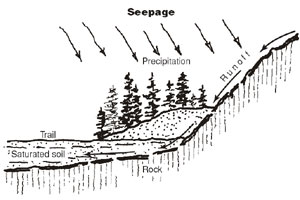
Figure 4—Seepage is sometimes caused
by
precipitation held in
perched water tables.
Another more obvious condition occurs near limestone cliffs. Limestone covers millions of square miles of the Earth's surface, and some limestones are extremely porous. Water will percolate deeply through certain types of limestone. Other types of limestone may be highly fractured, permitting water to penetrate. Water will seep out of the exposed faces (figure 5). This condition also occurs in sandstone formations.

Figure 5—Limestone formations are very porous.
Water will percolate
through the limestone and seep
out of exposed faces and cutslopes.
Spruce Bogs
The spruce bog is a forest type found in the northern United States and throughout Canada and Alaska. The forest often consists of pure stands of black spruce, a slow-growing tree that survives in dense shade where the water table is high. Walking through a mature stand of these trees is a unique experience. The trees may be 6 to 12 inches in diameter, 25 to 40 feet tall, 15 to 40 feet apart, and 200 years old. Because they can withstand shade, the trees are often densely branched to the ground.
In spruce bogs, roots spread on the surface, presenting a problem for trail construction. The roots may be 15 to 20 feet long and as big around as the tree. Large tree roots on one side of the trail spread out and cross into the root system of trees on the opposite side of the trail. Cutting the roots for normal trail construction would leave roots on either side of the trail and unbalance the trees' support. Hikers may trip over the roots if they are left in place. The surface soil is organic and breaks down quickly into ruts and mudholes. Hikers detour around these spots, creating a braided trail with two, three, or four alternative routes.
Muskeg
Muskeg refers to an area covered with sphagnum mosses and tufts of sedges. Muskeg is very common in Southeast Alaska, where all relatively open peat bogs with sphagnum mosses or sedges are called muskeg. The following information about muskeg is from the Alaska Region Trails Construction and Maintenance Guide (USDA Forest Service 1991).
Soils in Southeast Alaska maintain a thick, living, organic surface mat, a high percentage of iron oxides, and are often saturated with water. The soil structure breaks down readily under stress or disturbance.
Once the protective mantle and root layer are destroyed, the soil readily turns into water-muck. In some disturbed muskeg soils, there seems to be no limit to how far a person could sink. A site can go from solid footing to knee-deep muck after the trail crew makes just a few trips back and forth.
The volume of traffic these highly organic soils can support is directly related to the network of roots that exist in the soil. This network of roots strengthens the soil just as reinforcing bars strengthen concrete.
Wetlands With Wildlife That Bite Back
The last type of wetland has more to do with hydrology, climate, and wildlife than geology. Sites in the southeastern United States and tropical regions support species of wildlife that look upon man as prey. Building a normal wetland trail in these areas may be hazardous to the crew building the trail and to hikers unfamiliar with the potential dangers posed by local wildlife.
Alligators are often found in wetlands in the southern United States. Normally, alligators are not a problem to adult humans, but they may take an interest in a visitor's dog or small child. Little can be done to permanently keep them off the trail. Alligators may find a way through sturdy barrier fences that are improperly maintained, but may have a harder time finding their way off the fenced trail.

A loop trail should be considered in such areas. The loop trail provides the visitor with a route for hightailing it back to the trailhead, no matter where the alligator is encountered.
If alligators are the primary attraction for an interpretive trail, consider constructing an overlook. An overlook separates visitors from alligators and is an alternative to building a trail into the alligators' territory. In open areas, an overlook may be an effective way to see alligators. In areas with trees or dense brush, an overlook may not be worth the effort or expense. Guided boat trips might be another option for heavily-used locations.
Wetland trails in northern regions have their own potential wildlife challenges. Moose have a fondness for wetlands. Although usually docile, moose can be dangerous during some seasons. In the spring a cow moose is protective of her young. In the fall rutting season, a bull moose can be cantankerous and unpredictable. Moose have been known to attack people with no provocation and to follow wetland trails, including those with a wooden surface. Wetland trails in these areas might be designed with few abrupt curves and sight distances of at least 75 to 100 feet.
In the fall bull moose will demolish typical interpretive signs. One way to reduce sign damage is to use a vertical format for signs and place each sign on a single wide post (figure 6).
Wetlands with beaver, or where there is a possibility of beaver activity, pose different potential problems. Beavers are a natural draw for interpretive trails, but they might chew through wooden piles used to support the wooden deck of a trail. More importantly, they may change the water level of a wetland. A dam built upstream may reduce the flow of water into the wetland and reduce visitor enjoyment. A dam built downstream may raise the water level above the trail. Beavers may also plug culverts, weirs, and overflow structures. The level of the trail should be set higher to allow for higher water. A wetland trail that has been submerged because of beaver activity will require maintenance or reconstruction.

Figure 6—Installing signs that are designed to fit a single
post helps
prevent damage from moose.
