
Test Locations
Tests were conducted at three GPS test courses in western Montana and northern Idaho.
Open canopy tests were conducted at the Missoula Technology and Development Center (MTDC) facility near the Missoula airport, where there are no trees or obstructions of the sky. The check-in and HELP tests were conducted at a known survey marker. The check-in test was repeated nine times. The 24-hour tests were conducted on MTDC's roof where the device was secure.
Medium canopy tests were conducted at the GPS test course in the Lubrecht Experimental Forest northeast of Missoula. The test course is in a stand of lodgepole pine trees. Figures 5 and 6 show views of the canopy and the site.

Figure 5—This photo shows the view of the canopy
from
one of the test points within the Lubrecht GPS test course.

Figure 6—The SPOT device was tested under a medium
canopy at the GPS test course on the Lubrecht
Experimental Forest near Missoula, MT. The site is in
a lodgepole pine stand.
Heavy canopy tests were conducted at the GPS test course near Powell, ID, southwest of Missoula. The test course is in a stand of old-growth cedar and Douglas-fir trees. Figures 7, 8, and 9 show the site and views of the canopy.

Figure 7—The SPOT device was tested under a heavy
canopy
on a GPS test course at Powell, ID.
This view
is from the parking lot. The first survey marker is about
100 feet inside the stand.

Figure 8—One of the test points inside the test
course
at Powell, ID—the SPOT device is shown in the center.
The check-in message was successfully sent, even
though the unit was surrounded by large cedars.
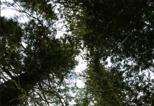
Figure 9—This photo shows the SPOT device's view of the canopy from the test point.