
Incident Sign
Ordering Catalog
Long Description Figure 3
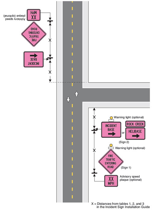
This image portrays a two-lane highway, with traffic proceeding in opposite directions on each lane of the road. At the center is a t-shaped road that merges into the main highway from the right side. Several signs are placed on the bottom right corner of the image:
- A diamond-shaped pink sign with a black border and black text is identified
as Sign 1 and reads Fire Traffic
Entering Road. At the top of the sign is an optional warning light
depicted as a graphic image with a yellow circle sitting on top of a small
white rectangular box.
- Directly under the bottom point of the diamond-shaped sign is a rectangular
pink sign with a black border and black text that reads XX
MPH, indicating that a specific recommended speed, in miles per hour,
would be printed on the sign. Text indicates that this advisory speed plaque
is optional.
- Placed further up the road is a rectangular pink sign with a black border and black text that reads Incident Base and includes a black arrow pointing to the right. At the top of the sign is an optional warning light depicted as a graphic image with a yellow circle sitting on top of a small white rectangular box. This sign, along with two alternative pink rectangular signs labeled Rock Creek and Helibase (with a black arrow pointing to the right) are identified as Sign 2.
At the bottom of the graphic the text reads, X= Distance from tables 1, 2, and 3 in the Incident Sign Installation Guide.
A similar series of signs is placed upside down at the top left corner of this image to indicate they would be placed in view of the oncoming traffic in the opposite lane of the highway.