
Visitor Maps and Guides
Forest Service Digital Maps
Looking for a map to help plan your trip to a national forest or grassland? Click the link below to access free downloadable maps.
Forest Visitor Map
Forest Visitor maps are forest-specific maps that provide forest-wide information on attractions, facilities, services, and opportunities. They are professionally printed with tear and water-resistant paper. Available for purchase in print and digital.
Interactive Visitor Map
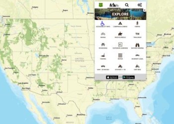
We have released the next-generation Interactive Forest Visitor Map! Map 2.0 provides the public with an online and mobile view of Forest Service roads, trails, recreation sites, wilderness areas, and wild and scenic rivers.
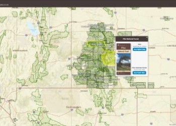
Eastern Region Motor Vehicle Use Map (MVUM) Finder
The interactive map below provides links to download Motorized Vehicle Use Maps. Each map is represented by a box indicating its coverage area. Downloads are available in geospatial PDF format or through the Avenza Map Store.
To locate a map to download
- Use the dropdown menus to select a forest or ranger district. After selecting, the map will zoom to your choice.
- Pan and zoom around the map and find the extent of the map you want to download and select it.
- To pan, click/tap and drag around the map.
- To zoom, use your mouse’s scroll wheel, pinch to zoom, or use the +/- buttons on the map.
- Once selected, a popup will display for the map extent. This will contain links to download the map directly or in the map in the Avenza Maps store.
Note: more than one map may be selected when you click or tap an extent. Select/tap the arrows or use the select features menu at the bottom of the popup to toggle between selected extents.
Avenza Mobile Maps
Find free and for purchase visitor maps and georeferenced PDF's through the Avenza mobile application.
USGS National Map Store
Purchase U.S. Forest Service Visitor Maps online
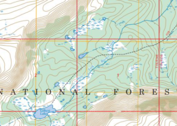
Forest Service Topographic Maps
FSTopo is the Forest Service series of large scale topographic maps. FSTopo maps are 7.5 minute, 1:24,000-scale over the conterminous United States, and 15 minute X 20-22.5 minute, 1:63,360-scale over Alaska. FSTopo maps are also available on the Forest Service Digital Maps website.
FS Geodata Clearinghouse
The Forest Service Geodata clearinghouse is an online collection of digital data related to forest resources. Through the Geodata Clearinghouse you can find datasets related to forests and grasslands. You can also find boundaries and ownership, natural resources, roads and trails, and datasets related to state, private, and tribal forested areas such as insect and disease threat and surface water importance. The information includes map products you can download, raster data, and links to other resources.
ArcGIS Online - Map Products
The Forest Service uses ArcGIS Online and Open Data to share maps, data, and applications for use by other federal agencies, partners, and the public.