
C.C. Cragin (Blue Ridge) Reservoir
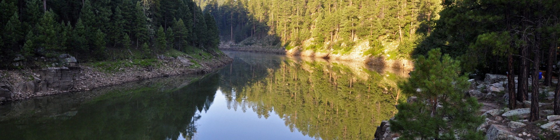
Fed by three watersheds, this narrow, winding body of water looks more like a canyon-bound river than a lake. Given the steep canyon walls that create the C.C. Cragin Reservoir, there is very little shore access around the entire reservoir, which makes this reservoir a destination mainly for kayakers, boaters and anglers. The Arizona Game and Fish Department uses the reservoir as a coldwater fishery for rainbow trout.
Other types of recreation include sightseeing, wildlife watching, hiking, and mountain biking, but don't expect any wide-open shores for sunbathing and swimming due to the steep walls that contain the reservoir.
Once known as Blue Ridge Reservoir, C.C. Cragin Reservoir is an important water source for the town of Payson, Arizona. Forest thinning and prescribed burning in the area under the Cragin Watershed Protection Project is helping to protect this valuable water source and improve forest health in the area. C.C. Cragin Dam was built in 1965 by Phelps Dodge and transferred to the Salt River Project in 2005.


Active Alerts
General Information
Open year-round except when seasonal road closures are in place.
- Boats are restricted to a single electric motor or a single gasoline engine 10 horsepower or less.
- No vehicles over 22 feet long on Forest Road (FR) 751 in restricted area southeast of Rock Crossing Campground.
- No vehicles with trailers in excess of 50 feet overall in restricted area.
- No parking except in designated parking spaces on FR 751 in restricted area.
- No swimming within 50 feet of a boat ramp or dock.
Observe boat ramp rules posted by Arizona Game and Fish:
- No parking on boat ramp. Wait for next available space.
- Boat launch area has a 5 minute maximum vehicle use.
- Do not block or interfere with boat launching.
- Use the make-ready area to prepare before using boat launch.
Pets must be restrained or kept on a leash at all times.

Address: 8738 Ranger Road, Happy Jack, AZ 86024
Phone: 928-477-2255
Hours: Monday-Friday, 7 a.m. - 3:30 p.m. (Closed on federal holidays)
Office Email: SM.FS.Cof_Webmail@usda.gov
Getting There
Latitude / Longitude
Latitude: 34.55451
Longitude: -111.19724
Elevation
6695 ft.
Directions
Location: 63 miles south of Flagstaff on a graveled forest road.
GPS (Map): 34°33'16.6"N 111°11'47.4"W
Access: Drive 55 miles south of Flagstaff to Clints Well on Lake Mary Road. Turn northeast (left) about 4 miles on state Route 87 to Forest Road (FR) 751, then southeast about 6 more miles to the reservoir. All roads are paved except FR 751 which is gravel and suitable for passenger cars in most weather.
Travel Considerations
Forest Road 751 closes during winter months, and the reservoir is not accessible. Check forest roads status here.
Parking
Parking is limited. Motorists are asked to abide by all posted signage and refrain from parking outside of designated parking areas. Please see the C.C. Cragin Reservoir Vehicle and Swimming Prohibitions Alert for more information.
Facility and Amenity Information
Water
Potable water is not available at this site.
Picnic Tables
Picnic tables are not available at this site.
Recreation Opportunities
Fishing - Lake & Pond Info
Anglers can catch rainbow trout here, stocked by the Arizona Game and Fish Department.
At some points, Green Sunfish were illegally introduced to C.C. Cragin Reservoir. There is no limit for Green Sunfish and the AGFD is asking that you immediately kill any Green Sunfish caught in C.C. Cragin Reservoir or East Clear Creek to help with the survival of and improve the trout fishery.
Boating - Motorized Info
Boats are restricted to a single electric motor or a single gasoline engine 10 horsepower or less.
Helpful Links:
Swimming Info
Swimming or wading within 50 feet of any portion of the reservoir boat launch ramp is prohibited. See the C.C. Cragin Reservoir Vehicle and Swimming Prohibitions Alert for more information.