
Red Mountain Trail No. 159
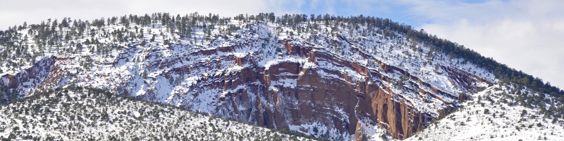
Red Mountain, located 25 miles northwest of Flagstaff, is a volcanic cinder cone that rises 1,000 feet above the surrounding landscape. It is unusual in having the shape of a "U," and in lacking the symmetrical shape of most cinder cones. In addition, a large natural amphitheater cuts into the cone's northeast flank. Erosional pillars called "hoodoos" decorate the amphitheater, and many dark mineral crystals erode out of its walls. Studies by U.S. Geological Survey (USGS) and Northern Arizona University scientists suggest that Red Mountain formed in eruptions about 740,000 years ago.
The trail itself is a mild walk with a gradual elevation gain, and there is a a short, sturdy ladder near the end of the trail at the entrance of the collapsed cone to get hikers up an approximately 6 foot rise. One can see the San Francisco Peaks off to the southeast as it peaks through portions of the trail lined with juniper, ponderosa pine, and high-desert plants.
For more details about Red Mountain, check out Red Mountain Volcano -- a Spectacular and Unusual Cinder Cone in Northern Arizona (PDF): brochure by the U.S. Geological Survey and the U.S. Forest Service.
Photo Gallery


Specific Trail Information
Trail Number
Trail Type
General Information
- Difficulty: Easy.
- Trailhead Elevation: 6,756 ft.
- Elevation Gain: 275 ft.
- Length: 1.5 miles.
- Time: About 30 mins one way.
- No overnight camping
- Dogs must always be on a leash, and owners must pick up after their pets. DO NOT leave bags of poop from your pets along the trail/trailhead for picking up later. If your pet defecates, you must bag the poop and take it with you. If you do not want to do this, do not bring your pet on trails.
Address: 5075 N. Highway 89, Flagstaff, AZ 86001
Phone: 928-526-0866
Hours: Monday-Friday, 8 a.m. - 4 p.m. (Closed on federal holidays)
Office Email: SM.FS.Cof_Webmail@usda.gov
Getting There
Directions
Location: 25 miles north of Flagstaff on paved highway.
Access: Head northwest on U.S. Highway 180. This highway snakes through the central part of the San Francisco Volcanic Field on its way toward the Grand Canyon. About 25 miles from Flagstaff (at milepost 247 along the shoulder of the highway), turn left at a large Forest Service sign that announces the Red Mountain Geologic Area. Drive about a quarter mile on the dirt road to a parking space at the trailhead. The walk from there to the base of Red Mountain takes about 30 minutes. Carry plenty of drinking water on a hot day (at least 1 liter of water per person). Trees in the natural amphitheater provide some shade.
GPS (Map): 35°32'11.8"N 111°51'23.3"W