
Oak Ridge Trailhead
Overview
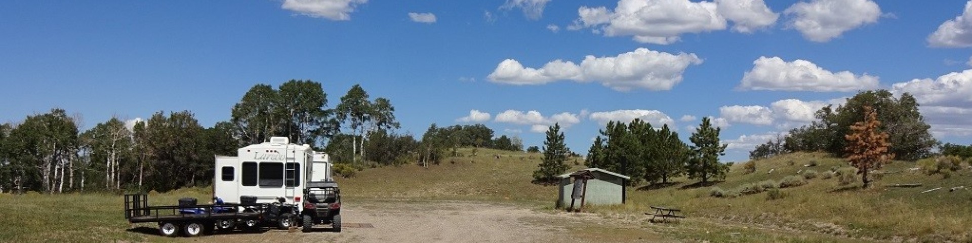
The Oak Ridge Trailhead is found on an old drill pad near the end of Forest Road 032 (FR-032), at an elevation of nearly 8,700 feet.
Facilities
Facilities include vault restroom, an information kiosk and a gravel parking area.
Natural Features
The trailhead is situated atop a windswept ridge surrounded by aspen and mixed conifer trees.
Recreation
The Great Western Trail for 50" ATVs, horseback riding, hiking, dispersed camping, hunting, and wildlife viewing are popular activities to enjoy nearby. Please pack-out what you pack-in. Camping stay limit is 16 days/15nights.
General Information
May - November
Open 24 hours/day
- Please refrain from cutting or breaking branches around dispersed campsites. Kindly bring your own firewood to help preserve the natural environment and camping experience.
- Camping stay limit is 16 days, 15 nights. After that you must relocate at least 5 road miles away if you wish to continue camping.
- Follow local fire restrictions and fully extinguish campfires before leaving.
- Pack out all trash and follow Leave No Trace principles.
- Use designated vault toilet to protect natural environment and wildlife.
- Use existing sites and park only on durable surfaces (not vegetation).
- Avoid creating new trails or campsites.
- Store food properly in bear-proof containers.
- All motorized travel is restricted to designated travel routes. Cross country travel, driving around closed gates and width restriction barriers, and driving on meadows is prohibited.
- All OHVs are required to be registered and display a permit or sticker for riding on public lands.
- Yield to hikers, horses and non-motorized users
No fees are required for this site
- Clean up dog waste and dispose of it properly.
- Keep dogs from chasing, harassing, and disturbing wildlife, livestock or other visitors
- Yield to other hikers, horses, and other trail users by stepping off the trail and controlling your dog
- Pets must be leashed at all times within this recreation area. This policy is in place to ensure the safety and enjoyment of all visitors and to protect wildlife.
Address: 115 East 900 North Richfield, UT 84701
Phone: (435) 896-9233
Hours: Monday - Friday, 8am - 4:30pm (Closed on federal holidays)
Getting There
Latitude / Longitude
Latitude: 38.83313889
Longitude: -111.6655194
Directions
Oak Ridge Trailhead is located approximately 22 miles southeast of Salina Utah. In Salina at the junction of Main Street and State Street, head south on State Street for approximately 2 miles until you reach I-70. Turn left (east) onto I-70 east-bound from Salina, for approximately 6.5 miles. Exit I-70 at Gooseberry Road (Exit 63) and then turn right (south) on the Gooseberry Road (County Road #640), a two-lane paved road, for about 10.6 miles. Turn left on the Oak Ridge Road (FR032) for 3 miles to the trailhead.
Parking
Gravel parking area
Facility and Amenity Information
Restrooms
Restrooms are available at this site.
Water
Potable water is not available at this site.
Picnic Tables
Picnic tables are not available at this site.
Horse/Pack Animal Information
Horse/Pack animals are allowed at this site.
- Stay on designated trails.
- Use weed-free hay to prevent the spread of invasive plant species.
- Tie horses to trees in a way that won't damage the tree.
Recreation Opportunities
OHV Trail Riding Info
The Great Western Trail out of this site is open only to vehicles 50 inches or less in width.