
Rock Creek Wilderness
Rock Creek Wilderness is one of the Siuslaw’s most remote wildernesses with no developed trails or trailheads. You'll need to travel cross country using a map and compass - a real wilderness experience.
Pristine rain forest canyons run with crystalline water pouring into either Rock Creek itself in the heart of the Wilderness or Big Creek on the southern boundary. Mossy big leaf maple and red alder hang suspended over both creeks as they make their way toward the salty waves of the Pacific Ocean. Near the coast, tremendous old-growth Sitka spruce sometimes reach nine feet in diameter, giving way to old Douglas fir farther inland. Pink-blossomed rhododendron bloom in May, joining salal, salmonberry, and sword fern in their efforts to keep the ground perpetually shaded.
Look carefully for Oregon Silverspot butterflies on the tall ridge between Rock and Big Creeks; these orange-and-brown butterflies live only here and in two other places on earth. Salmon, steelhead, and cutthroat trout migrate up creek to spawn.
Fog cools the area almost all of every summer; and winters are usually snow free.
General Information
- Wilderness Regulations & Guidelines
- No Drones
Within developed recreation sites, dogs must be on a leash no longer than 6 feet, or otherwise under physical restrictive control. 36 CFR 261.16(j)
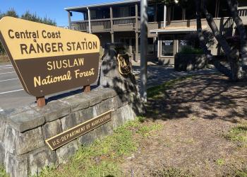
Address: 1130 Forestry Lane Waldport , OR 97394
Phone: (541) 563-8400
Hours: Monday–Friday, 8:00 a.m. – 4:00 p.m. (Closed on federal holidays)
Office Email: r6_siuslaw_wwweb_front_desk@usda.gov
Getting There
Directions
Rock Creek Wilderness is located in the Oregon Coast Range south of Waldport and north of Florence, Oregon. Off the Coastal Highway 10 miles south of Yachats, Oregon.
Topo Maps
Download free U.S. Forest Service Topo maps here.
Wilderness.net
Go to Wilderness.net for online maps and other important Wilderness information.
Facility and Amenity Information
Restrooms
Restrooms are not available at this site.
Water
Potable water is not available at this site.
Picnic Tables
Picnic tables are not available at this site.
Horse/Pack Animal Information
Horse/Pack animals are not allowed at this site.