
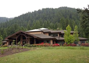
Clark Creek Organization Camp
Clark Creek Organization Camp, located 12 miles northeast of Lowell, Oregon, is a historic group campground constructed during the 1930s by the efforts of the Civilian Conservation Corps in coordination with the U.S. Forest Service. Organization camps were created for the purpose of hosting group recreational activities on public lands. Historically, groups that routinely used organization camps were the Boy Scouts of America and local church groups.
The camp features five bunkhouses each with eight platform sleeping bunks, plus a large field to pitch tents, play baseball, volleyball or throw a frisbee. There is also an amphitheater, cooking/dining shelter, and chapel. The day-use area and sleeping shelters are separated by Clark Creek. Access is over a foot bridge. The site accommodates up to 80 overnight guests but up to 125 guests can make use of the group area during the day time. Clark Creek is extremely popular for group events and functions, so plan ahead when making reservations.
Several hiking and biking trails, swimming areas and open fields offer fun opportunities for large groups with varied interests. Fall Creek is located across Forest Road 18, and Clark Creek runs adjacent to the sleeping area.
General Information
Check in: 2:00 p.m.; Check-out: 12:00 p.m.; Quiet hours are 10:00 p.m. until 6:00 a.m.
No passes honored.
- Vehicles are prohibited from driving in the grass field
- Camping is not allowed more than 14 days in a 60 day period.
- Check-in time: 2:00 pm or later. Check-out time: 1:00 pm
- Use of chainsaws in the campground is prohibited
- Dogs MUST be on leash at all times within the campground
Overnight Use:
Group Site: $240 per night, Sunday-Thursday
Group Site: $280 per night, Friday-Saturday
- Group Campsite - $240 per night, Sunday-Thursday
- Group Campsite - $280 per night, Friday-Saturday
Address: 46375 Highway 58 West Fir, OR 97492
Phone: (541) 782-2283
Hours: Monday-Friday, 10:00 a.m. - 4:30 p.m. (Closed on federal holidays)
Office Email: sm.fs.mfrd@usda.gov
Getting There
Latitude / Longitude
Latitude: 43.97319
Longitude: -122.57908
Directions
Approximately 15 miles northeast of Lowell, Oregon
Beginning at the Lowell Junior/Senior High School at 65 South Pioneer Street, head north for 0.1 mile. Turn left at the 2nd cross street onto North Shore Drive. Travel for another 0.1 mile and turn right at the first cross street, which is South Moss Street. In approximately 0.8 miles, South Moss Street becomes the Jasper-Lowell Road. Continue for another 1.0 mile until the four-way stop. Turn right onto Big Fall Creek Road. Approaching the base of the Fall Creek Lake dam, bear to the left after passing Winberry Creek Road (on your right). Note that Big Fall Creek Road becomes Forest Road 18 after crossing the National Forest boundary. Travel for 12.7 miles and the destination will be on your left.
Facility and Amenity Information
Restrooms
Restrooms are available at this site.
Water
Potable water is not available at this site.
Picnic Tables
Picnic tables are available at this site.
Horse/Pack Animal Information
Horse/Pack animals are not allowed at this site.