Resilient Ecosystems and Adaptive Landscapes (REAL) Planning
We sit at a threshold in time where increasing temperatures, more extreme weather events, and growing wildfire risk require us to quickly adapt management needs on the landscapes we steward alongside our partners and the public. For example, over the last decade, the Monongahela National Forest has experienced at least five storm events resulting in millions of dollars of damage to roads, recreation sites, and hundreds of acres of wind-thrown trees. Several pests and pathogens (e.g. variety of oak diseases, emerald ash borer, beech bark disease, hemlock wooly adelgid, etc.) continue to threaten our forests. Now more than ever, the resiliency of National Forests is critical to supporting local communities.
In 2020, the Monongahela National Forest developed a watershed-based planning strategy (Order of Entry) to provide an efficient National Environmental Policy Act (NEPA) review and decision-making process. The purpose of this effort was to implement the 2006 Land and Resource Management Plan (Forest Plan) and move the Forest toward the desired future conditions as laid out in the Forest Plan. This approach took the guess work out of planning and provided an opportunity for aligning projects with partners and stakeholders.
Through an internal review of our processes, we have developed ways to improve our planning efforts. The Forest’s Resilient Ecosystems and Adaptive Landscapes (REAL) Planning strategy updates the 2020 process, with the ultimate goal of managing for healthy and resilient forests and watersheds that can recover from disturbances such as flooding, droughts, fires, insects, and diseases. Forest leadership will regularly review watershed priorities and monitor timelines to keep our teams on target. Integrating resource areas is key to success, from project pre-planning through implementation and monitoring. The teams will focus on the actions that are needed in the watershed over the next decade, recognizing the area will be revisited in about ten years. Planning efforts will focus on the target watershed, delaying proposals for actions in other watersheds until the appropriate time. The Forest will use the most efficient and appropriate level of NEPA analysis to bring existing conditions closer to the Forest Plan desired conditions, including utilizing Categorical Exclusions (CEs) when applicable.
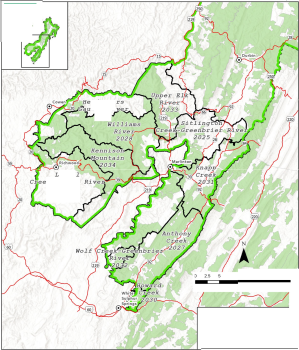
Using this strategy, the Forest plans to sustain two large-scale projects simultaneously, one each on the North and South Zones, using a two-year planning cycle that includes approximately one year of pre-planning and data collection, followed by one year of NEPA (public scoping through decision). The anticipated project commencement dates are included in the table and maps below.
As we continue to implement REAL Planning, it is important that we remain flexible and adaptive to achieve ambitious outcomes. We will move forward with open collaboration, creativity, and steadfast determination to create the resilient ecosystems that provide vital services, such as clean air and water, productive soils, carbon sequestration, fish and wildlife habitat, recreation opportunities, timber products and more to the American people.
| Project Name | Project Commencement Year | Lead District | Forest Service Acres | Planning Area Acres |
| North Zone | ||||
| Upper Shavers- Tygart Valley | 2025 | Greenbrier | 95,001 | 231,387 |
| Haddix Run- Shavers Fork | 2026 | Cheat-Potomac | 30,910 | 84,362 |
| Upper Glady | 2027 | Greenbrier | 38,488 | 62,724 |
| Dry Fork East | 2028 | Cheat-Potomac | 45,922 | 93,422 |
| Upper Greenbrier River | 2029 | Greenbrier | 69,840 | 85,256 |
| Upper North Fork Potomac | 2030 | Cheat-Potomac | 37,162 | 104,775 |
| Dry Fork West | 2031 | Cheat-Potomac | 49,019 | 74,852 |
| Blackwater River | 2032 | Cheat-Potomac | 16,878 | 89,265 |
| Upper Cheat River | 2033 | Cheat-Potomac | 34,098 | 141,701 |
| Deer Creek* | 2034 | Greenbrier | 40,253 | 89,123 |
| Potomac** | 2035 | Cheat-Potomac | 66,257 | 383,103 |
| South Zone | ||||
| Sitlington Creek- Greenbrier River | 2025 | Marlinton-White Sulphur | 50,288 | 200,313 |
| Laurel Creek- Cherry River | 2026 | Gauley | 28,846 | 106,481 |
| Anthony Creek | 2027 | Marlinton-White Sulphur | 72,003 | 94,605 |
| Williams River | 2028 | Gauley | 73,435 | 82,671 |
| Headwaters Gauley River | 2029 | Gauley | 17,779 | 86,380 |
| Howard Creek | 2030 | Marlinton-White Sulphur | 7,574 | 58,531 |
| Knapp Creek | 2031 | Marlinton-White Sulphur | 40,809 | 69,924 |
| Wolf Creek- Greenbrier River | 2032 | Marlinton-White Sulphur | 8,561 | 203,371 |
| Upper Elk River | 2033 | Marlinton-White Sulphur | 33,941 | 154,315 |
Kennison Mountain** | 2034 | Gauley | 67,797 | 139,383 |
*Although the opportunity for public comment has passed, the NEPA process for the Deer Creek project is ongoing and we expect a 2025 decision, with the next planning cycle anticipated in 2034. **The Potomac and Kennison Mountain projects are in the early stages of the NEPA process with decisions expected in 2026.Their next planning cycles are expected to begin in 2035 and 2034, respectfully. | ||||

| Headquarters | North Zone | South Zone |
| Monongahela National | Cheat-Potomac Ranger District | Marlinton-White Sulphur Ranger |
| Forest | District Ranger Jon Morgan | District |
| Forest Supervisor | District Ranger Jason Hattersley | |
| Cynthia 'Cindy' Sandeno | Petersburg Office | |
| 2499 North Fork Highway | Marlinton Office | |
| Deputy Forest Supervisor | Petersburg, WV 26847 | 1627 Cemetery Road |
| Sarah LaPlante | 304-257-4488 (Voice& TDD) | Marlinton, WV 24954-0210 |
| 304-799-4334 (Voice &TDD) | ||
| Supervisor’s Office | Parsons Office | |
| 200 Sycamore Street | 459 Nursery Bottom | White Sulphur Springs Office |
Elkins, WV 26241 304-636-1800 (Voice& TDD) | Parsons, WV 26287 304-478-2000 (Voice& TDD) | 1079 MainStreet East White Sulphur Springs, WV 24986 304-536-2144 (Voice & TDD) |
| Greenbrier Ranger District | Gauley Ranger District | |
| District Ranger J Tribble | District Ranger Dannon Dirgo | |
| 7409 Staunton Parkersburg | 932 North Fork Cherry Road | |
| Turnpike Bartow, WV 24920 | Richwood, WV 26261 | |
| 304-456-3335 (Voice & TDD) | 304-846-2695 (Voice& TDD) |