| FEIS Home Page |
Citation:
U.S. Department of Agriculture, Forest Service, Missoula Fire Sciences Laboratory. 2018. Fire regimes of California montane mixed-conifer communities: Information from the Pacific Southwest Research Station and LANDFIRE.
In: Fire Effects Information System, [Online].
U.S. Department of Agriculture, Forest Service,
Rocky Mountain Research Station, Missoula Fire Sciences Laboratory (Producer).
Available: www.fs.usda.gov/database/feis/fire_regimes/CA_mixed_conifer/all.html
[].
PACIFIC SOUTHWEST RESEARCH STATION
The Pacific Southwest Research Station, Forest Service, U.S. Department of Agriculture, provides a General Technical Report on historical range of variability for California montane mixed-conifer communities (Safford et al. 2017
[4]). The fire section of that report is summarized here. Ponderosa pine communities occur from about 1,000 to 5,900 feet (300-1,800 m) in northern California and about 4,000 to 6,900 feet (1,200-2,100 m) in southern California. Jeffrey pine communities occur from about 4,900 to 7,900 feet (1,500-2,400 m) in northern and 5,600 to 9,200 feet (1,700-2,800 m) in southern California. Both pines also occur in montane mixed-conifer forests, so boundaries between "yellow pine" and montane mixed-conifer forests are not discrete ("yellow pine" refers to both ponderosa and Jeffery pines). The mixed-conifer zone extends from around 4,000 feet (1,200 m) to 6,500-7,500 feet (2,000-2,300 m) or more, depending on latitude, with the upper elevational range falling within the zone of maximum snowfall. See
table A1
for scientific names of plants and for links to FEIS Species Reviews.
 |
 |
| Ponderosa pine forest in Trinity County. Image used with permission of J. E. (Jed) and Bonnie McClellan © California Academy of Sciences. | Jeffrey pine forest in Mono County. Image used with permission of Charles Webber © California Academy of Sciences. |
 |
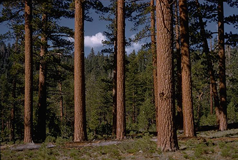
| Montane mixed-conifer forest on the San Bernardino National Forest. Wikimedia Commons image by Randy McEoin. |
Presettlement Fire Regime
Historically, the fire season in yellow pine and montane mixed-conifer (YPMC) forests ran from late June to October.
Under presettlement conditions, YPMC forests in the Sierra Nevada supported fire regimes characterized by frequent,
low- to moderate-severity fires.
This indicates that presettlement YPMC forests were in Fire Regime I
(fire intervals of 0-35 years). Among forest types of California, fire were most frequent in low-elevation yellow pine forests and high-elevation mixed-conifer forests. Averaged across the state, Safford et al. report fire intervals ranged from 11 to 16 years in presettlement (1600s to about 1850) YPMC forests, and median fire intervals ranged from 7 to 12 years. Mean minimum fire intervals were around 5 years for both forest types, and mean maximum fire intervals ranged from 40 to 80 years (table 1) [4].
| Table 1—Presettlement fire intervals (years) for California yellow pine and montane mixed-conifer forests (modified from [4, 5])1. | |||||
| Forest type | Mean | Median | Mean minimum2 | Mean maximum | Number of sources |
| Yellow pine | 11 | 7 | 5 | 40 | 24 |
| Dry mixed conifer | 11 | 9 | 5 | 50 | 37 |
| Moist mixed conifer | 16 | 12 | 5 | 80 | 53 |
| 1Sources include fire histories derived from dendrochronological and charcoal deposition records, modeling studies, and expert quantitative estimates [4]. 2Mean minimum and mean maximum are rounded to the nearest multiple of 5. |
|||||
Fires were mostly low severity surface fires. Passive crown fires occurred occasionally in mature trees, and young stands could carry active crown fires. Large, severe fires were "comparatively rare". However, fire severity was not uniform across YPMC landscapes in presettlement times. Across California, generally <10% of YPMC forests burned at high severity in a given year. At smaller scales, fire severity varied with site fire history, elevation, slope, and stand species composition. Generally, fire severity was highest on north-facing slopes, riparian areas, and stands with high concentrations of coast Douglas-fir, white fir, or other firs [4].
Patches of severe fire were generally small historically, although patches occurred occasionally. Most high-severity patches were only a few hectares in size. Across California's YPMC zone, patches of high-severity fire were rarely >250 acres (100 ha). A reconstruction of an 1899 montane mixed-conifer stand in Yosemite National Park suggests that patches of high-severity fire were <0.5 acre (0.2 ha). Large canopy gaps (>250 acres (100 ha)) that were repopulated with single-aged stands of trees after fire were most common in upper northern California, where climate is more moist and fir species form denser stands than farther south [4].
Fires in presettlement YPMC forests were generally small in size, but numerous. A review of fires >25 acres (10 ha) in size found that presettlement fires averaged 519 acres (210 ha) (range of means: 210-1,129 acres (85-457 ha)). An estimated 450,000 to 1.4 million acres (180,000-550,000 ha) burned annually in presettlement YPMC forests, or from 5% to 15% of the total YPMC forest area in California [4].
Contemporary Changes
The fire season is lengthening in California. Earlier snowmelt and warmer summer temperatures has lengthened the fire season by at least 2 months. Contemporary fire intervals in YPMC forests are much longer than in presettlement times. Because of human influences since Euro-American settlement, including timber harvest, grazing, and fire suppression, many YPMC forests in California support conditions that are more characteristic of Fire Regimes III (fire intervals of 35-200 years, moderate severity) and IV (fire intervals of 35-200 years, high severity). Figure 1 shows estimated mean percentage departure from presettlement fire intervals. In presettlement times, an estimated 9.1 fires occurred in YPMC forests over 100 years (i.e., mean fire interval of ~11 years).
Areas in figure 1 that are >67% departed from presettlement fire intervals (dark blue colors) experienced 3 or fewer fires in the 20th century. Southern and eastern regions are less departed than northern and central regions (figure 1). YPMC forests were the most departed of 28 vegetation types that occur across California. About three-fourths of YPMC did not experience a fire from 1909-2000 [4].
 |
| Figure 1—Mean percentage of fire-return interval departure (PFRID) on Forest Service and National Park Service lands in California. Land with warm colors have more fire than in presettlement times; cool colors have less fire [4, 5]. |
Based on vegetation maps and modeling of National Forest lands, fires in YPMC forests are burning at higher severities than they burned historically (30-35% high severity vs. 3-15%), and patch sizes of severe fire are larger. Presettlement size of high-severity patches averaged <0.5 acre (0.2 ha), whereas 1984 and 2006, high-severity patches averaged 30 acres (12.2 ha). Mean size of patches that burned at high severity nearly doubled during that time [4].
Fires in YPMC are apparently larger in extent than in presettlement times. From 1986 to 2011, fires in YPMC averaged 3,460 acres (140 acres SE) (1,400 ha, 55 ha SE), about 5 times the historical size. However, because many fires are suppressed, area burned annually is less than that estimated for presettlement YPMC forests. From 1984 to 2009, mean of 46,500 acres (18,800 ha) burned annually in YPMC forests [4].
LANDFIRE MODELING
Estimated fire regime characteristics are available from LANDFIRE succession modeling of
Biophysical Settings (BpS).
Table 2 summarizes these estimates for the BpSs in California montane mixed-conifer communities. Figure 2 shows where they occur.
Table A2
lists the BpSs and the results of LANDFIRE succession modeling for each BpS.
| Table 2—Modeled fire intervals and severities in northern California montane mixed-conifer communities [3] | |||||||||
| Fire interval¹ | |||||||||
| Replacement | Mixed | Low | I | II | III | IV | V | NA³ | |
| 7-24 years | 4-12 | 0-48 | 43-93 | 28 | 0 | 0 | 0 | 0 | 0 |
| ¹Average historical
fire interval
derived from LANDFIRE succession modeling (called "mean fire-return interval" in LANDFIRE). ²Percentage of fires in 3 fire severity classes, derived from LANDFIRE succession modeling. Replacement-severity fires cause >75% kill or top-kill of the upper canopy layer; mixed-severity fires cause 26%-75%; low-severity fires cause <26% [1,2]. ³NA (not applicable) refers to BpS models that did not include fire in simulations. |
|||||||||
 |
| Figure 2—Land cover distribution of California montane mixed-conifer communities based on the LANDFIRE Biophysical Settings (BpS) data layer [3]. Click on the map for a larger image and zoom in to see details. |
| Table A1—Names of overstory tree species common in yellow pine and montane mixed-conifer communities. Links go to FEIS Species Reviews. | |
| Common name | Scientific name |
| California black oak | Quercus kelloggii |
| coast Douglas-fir | Pseudotsuga menziesii var. menziesii |
| incense-cedar | Calocedrus decurrens |
| Jeffery pine¹ | Pinus jeffreyi |
| firs | Abies spp. |
| ponderosa pine¹ | Pinus ponderosa var. benthamiana, P. ponderosa var. ponderosa |
| sugar pine | Pinus lambertiana |
| white fir | Abies concolor |
| ¹Yellow pine. | |