

|
|
FEIS Home Page |
Citation:
U.S. Department of Agriculture, Forest Service, Missoula Fire Sciences Laboratory. 2020. Information from LANDFIRE on fire regimes of inter-mountain basins semi-desert shrub-steppe communities.
In: Fire Effects Information System, [Online].
U.S. Department of Agriculture, Forest Service,
Rocky Mountain Research Station, Missoula Fire Sciences Laboratory (Producer).
Available: www.fs.usda.gov/database/feis/fire_regimes/Inter-mountain_basins_shrub-steppe/all.html
[].
A complete Fire Regime Synthesis for inter-mountain basins semi-desert shrub-steppe communities has not yet been published in the Fire Effects Information System. However, information is available from LANDFIRE succession modeling of inter-mountain basins semi-desert shrub-steppe Biophysical Settings (BpS). Table 1 summarizes LANDFIRE data for inter-mountain basins semi-desert shrub-steppe BpSs. Figure 1 shows where they occur. Appendix A lists the inter-mountain basins semi-desert shrub-steppe BpSs and provides results of LANDFIRE succession modeling and links to descriptions for each BpS.
| Table 1—Range of modeled historical mean fire intervals and percentage of historical fires in each of three fire severity classes for inter-mountain basins semi-desert shrub-steppe Biophysical Settings (BpS), and the number of these BpSs in each fire regime group [2]. See Appendix A for details specific to each BpS. | |||||||||
| Mean Fire Interval (years) | Replacement-severity Fires (%) |
Mixed-severity Fires (%) | Low-severity Fires (%) | Fire Regime Group I |
Fire Regime Group II | Fire Regime Group III | Fire Regime Group IV | Fire Regime Group V | Fire Regime Group NA |
| 105–226 | 100 | 0 | 0 | 0 | 0 | 0 | 3 | 4 | 0 |
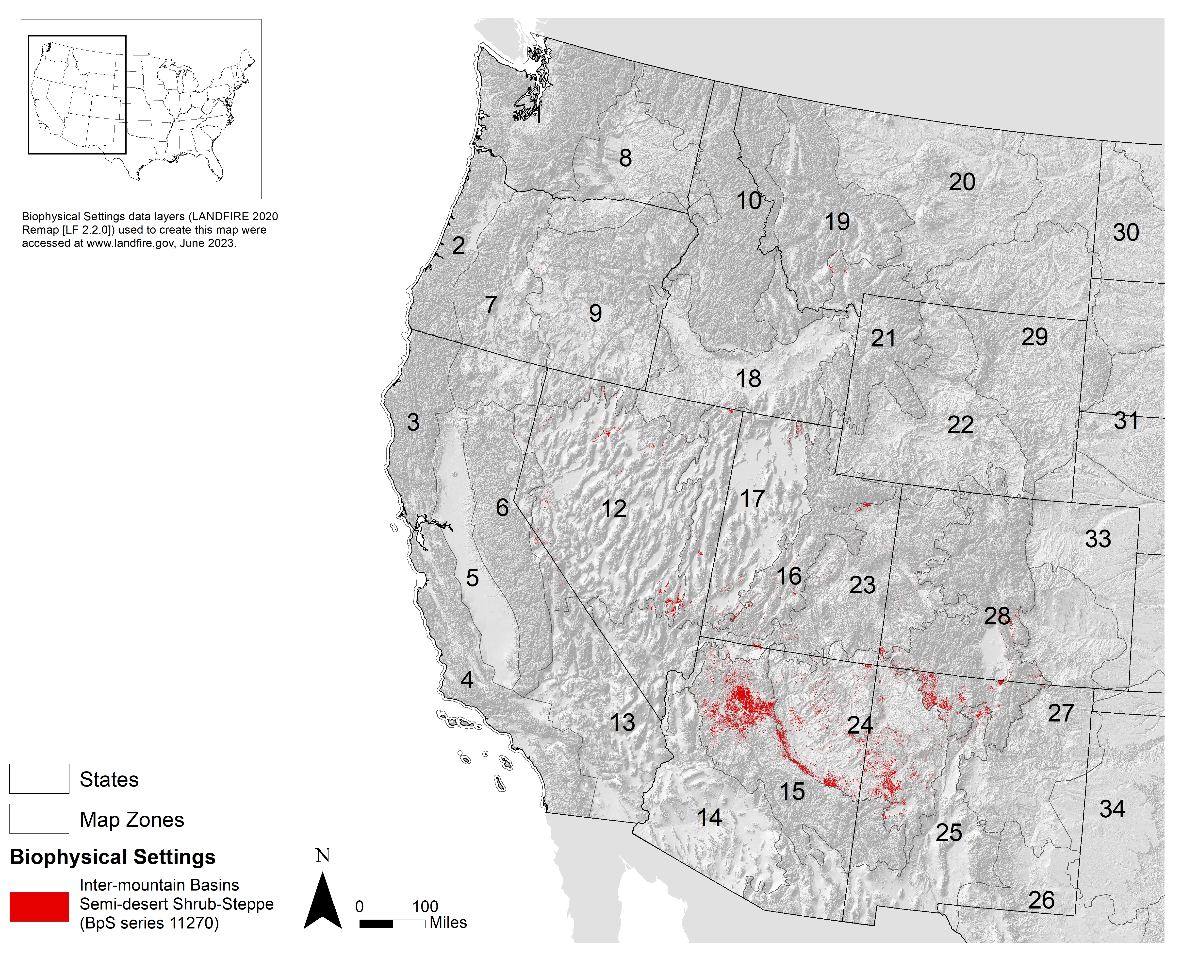 |
| Figure 1—Land cover distribution of inter-mountain basins semi-desert shrub-steppe Biophysical Settings (BpS) based on the LANDFIRE (2020) BpS data layer [1]. Numbers indicate LANDFIRE map zones. Click on the map for a larger image. |
1. LANDFIRE. 2020. Biophysical settings layer, CONUS (LANDFIRE 2.2.0). In: LANDFIRE download data mosaic products, [Online]. U.S. Department of the Interior, Geological Survey; U.S. Department of Agriculture (Producer). Available: https://www.landfire.gov/version_download.php [2023, June 20]. [98050]
2. LANDFIRE. 2020. Biophysical settings models and descriptions, [Online]. Washington, DC: U.S. Department of Agriculture, Forest Service; U.S. Department of the Interior; U.S. Geological Survey; Arlington, VA: The Nature Conservancy, (Producers). Available: http://www.landfirereview.org/search.php [2022, February 2]. [96496]