Fire regimes of red fir communities
Citation:
U.S. Department of Agriculture, Forest Service, Missoula Fire Sciences Laboratory. 2019. Fire regimes of red fir communities: Information from Information from the Pacific Southwest Research Station and LANDFIRE.
In: Fire Effects Information System, [Online].
U.S. Department of Agriculture, Forest Service,
Rocky Mountain Research Station, Missoula Fire Sciences Laboratory (Producer).
Available: https://www.fs.usda.gov/database/feis/fire_regimes/Red_fir/all.html
[].
Information from:
PACIFIC SOUTHWEST RESEARCH STATION
The Pacific Southwest Research Station, Forest Service, U.S. Department of Agriculture, provides a review and synthesis of the historical range of variability in red fir communities (Meyer 2016
[4]). It includes information on:
- Physical setting and geographic distribution
- Ecological setting
- Holocene history
- Cultural-socioeconomic setting
- Reference conditions
- Descriptions of natural range of variation including:
- plant community composition (geographic distribution of major hardwood species, successional changes, diversity)
- stand structure (age class; cover, density, and basal area; patch sizes; distribution of fuel loads)
- function (climate; disturbances including fire, grazing, insects and disease; wind and volcanism; climatic water deficit)
- Deviations from natural variation and future trends
The literature review of fire regimes occurs in the in the "NRV descriptions and comparisons to current conditions" section of this publication.
 |
| A red fir community at Glacier Point, Yosemite National Park. Image by Charles Webber © California Academy of Sciences. Used with permission. |
LANDFIRE MODELING
LANDFIRE modeled succession and fire frequency of Biophysical Settings (BpSs). Table 1 summarizes LANDFIRE data on the BpSs for red fir communities. Figure 1 shows where they occur. Table A1 lists the BpSs and the results of LANDFIRE succession modeling for each BpS.
| Table 1—Modeled fire intervals and severities for red fir communities [3]. |
| Fire intervala |
Fire severityb (% of fires)
|
Number of Biophysical Settings (BpSs) in each fire regime group
|
| |
Replacement |
Mixed |
Low |
I |
II |
III |
IV |
V |
NAc |
| 16-66 years |
18-23 |
16-29 |
52-66 |
4 |
0 |
1 |
0 |
0 |
0 |
aMean historical
fire interval
derived from LANDFIRE succession modeling (labeled "MFRI" in LANDFIRE).
bPercentage of fires in 3 fire severity classes, derived from LANDFIRE succession modeling. Replacement-severity fires cause >75% kill or top-kill of the upper canopy layer; mixed-severity fires cause 26%-75%; low-severity fires
cause <26% [1,2].
cNA (not applicable) refers to BpS models that did not include fire in simulations. |
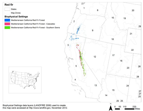 |
| Figure 1—Distribution of red fir communities based on the LANDFIRE Biophysical Settings (BpS) data layer
[3]. Numbers indicate LANDFIRE
map zones. Click on the map for a larger image. |
References:
1. Barrett, S.; Havlina, D.; Jones, J.; Hann, W.; Frame, C.; Hamilton, D.; Schon, K.; Demeo, T.; Hutter, L.; Menakis, J. 2010. Interagency fire regime condition class guidebook (FRCC), [Online], (Version 3.0). In: Interagency fire regime condition class website. U.S. Department of Agriculture, Forest Service; U.S. Department of the Interior; The Nature Conservancy (Producers). Available: https://www.frames.gov/documents/frcc/documents/FRCC+Guidebook_2008.10.30.pdf [2019, March 20]. [85876]
2. LANDFIRE Rapid Assessment. 2005. Reference condition modeling manual (Version 2.1). Cooperative Agreement 04-CA-11132543-189. Boulder, CO: The Nature Conservancy; U.S. Department of Agriculture, Forest Service; U.S. Department of the Interior. 72 p. On file at: U.S. Department of Agriculture, Forest Service, Rocky Mountain Research Station, Fire Sciences Laboratory, Missoula, MT. [66741]
3. LANDFIRE. 2008. CONUS refresh (LANDFIRE 1.1.0). Biophysical settings layer. In: LANDFIRE data distribution site, [Online]. In: LANDFIRE. U.S. Department of the Interior, Geological Survey (Producer). Available: https://landfire.cr.usgs.gov/viewer/ [2015, October 7]. [89416]
4. Meyer, Marc D. 2016. Natural range of variation of red fir forests in the bioregional assessment area, [Online]. In: Pacific Region, Ecology program documents, reports and publications, Natural range of variation of Sierra Nevada habitats. Vallejo, CA: U.S. Department of Agriculture, Forest Service, Pacific Southwest Region (Producer). Available: https://www.fs.usda.gov/detail/r5/plants-animals/?cid=stelprdb5434436 [2016, November 4]. 37 p. [+ tables & figures]. [91158]
FEIS Home Page
