| FEIS Home Page |
| Table A1—Common and scientific names of plant species mentioned in this synthesis. For further information on fire ecology of these taxa, follow the highlighted links to FEIS Species Reviews. Nonnative species are indicated with an asterisk (*). | |
| Common name | Scientific name |
| Forbs | |
| agoseris | Agoseris spp. |
| avens | Geum spp. |
| balsamroot | Balsamorhiza spp. |
| buckwheat | Eriogonum spp. |
| cinquefoil | Potentilla spp. |
| desertparsley | Lomatium spp. |
| fleabane | Erigeron spp. |
| hawksbeard | Crepis spp. |
| Indian paintbrush | Castilleja spp. |
| lupine | Lupinus spp. |
| milkvetch | Astragalus spp. |
| phlox | Phlox spp. |
| yarrow | Achillea spp. |
| Graminoids | |
| bearded wheatgrass | Elymus caninus |
| bluebunch wheatgrass | Pseudoroegneria spicata |
| blue grama | Bouteloua gracilis |
| bottlebrush squirreltail | Elymus elymoides |
| brome sixweeks grass* | Vulpia bromoides |
| California brome | Bromus carinatus |
| cheatgrass* | Bromus tectorum |
| crested wheatgrass* | Agropyron cristatum |
| Columbia needlegrass | Achnatherum nelsonii |
| Fendler bluegrass | Poa fendleriana |
| Idaho fescue | Festuca idahoensis |
| medusahead* | Taeniatherum caput-medusae |
| melicgrass | Melica spp. |
| needle-and-thread grass | Hesperostipa comata |
| needlegrass | Achnatherumspp. |
| Parry's oatgrass | Danthonia parryi |
| pinegrass | Calamagrostis rubescens |
| prairie Junegrass | Koeleria macrantha |
| rough fescue | Festuca campestris |
| saline wildrye | Leymus salinus |
| Sandberg bluegrass | Poa secunda |
| sedge | Carex spp. |
| slender wheatgrass | Elymus trachycaulus |
| Thurber fescue | Festuca thurberi |
| Thurber needlegrass | Achnatherum thurberianum |
| tufted hairgrass | Deschampsia cespitosa |
| ventenata | Ventenata dubia |
| western needlegrass | Achnatherum occidentale |
| western wheatgrass | Pascopyrum smithii |
| Shrubs | |
| antelope bitterbrush | Purshia tridentata |
| basin big sagebrush | Artemisia tridentata subsp. tridentata |
| big sagebrush | Artemisia tridentata |
| black sagebrush | Artemisia nova |
| green ephedra | Ephedra viridis |
| horsebrush | Tetradymia spp. |
| low sagebrush | Artemisia arbuscula |
| Mojave big sagebrush | Artemisia tridentata subsp. parishii |
| mountain big sagebrush | Artemisia tridentata subsp. vaseyana |
| mountain silver sagebrush | Artemisia cana subsp. viscidua |
| mountain snowberry | Symphoricarpos oreophilus |
| rabbitbrush | Chrysothamnus spp., Ericameria spp. |
| rubber rabbitbrush | Ericameria nauseosa |
| sagebrush | Artemisia spp. |
| Saskatoon serviceberry | Amelanchier alnifolia |
| silver sagebrush | Artemisia cana |
| snowbrush ceanothus | Ceanothus velutinus |
| snowfield big sagebrush | Artemisia tridentata subsp. spiciformis |
| spineless horsebrush | Tetradymia canescens |
| stiff sagebrush | Artemisia rigida |
| threetip sagebrush | Artemisia tripartita |
| wax currant | Ribes cereum |
| wild crab apple | Peraphyllum ramosissimum |
| Woods' rose | Rosa woodsii |
| Wyoming big sagebrush | Artemisia tridentata subsp. wyomingensis |
| xeric big sagebrush | Artemisia tridentata subsp. xericensis |
| yellow rabbitbrush | Chrysothamnus viscidiflorus |
| Trees | |
| California juniper | Juniperus californica |
| Colorado pinyon | Pinus edulis |
| cottonwood | Populus spp. |
| curlleaf mountain-mahogany | Cercocarpus ledifolius |
| Douglas-fir | Pseudotsuga menziesii |
| juniper | Juniperus spp. |
| limber pine | Pinus flexilis |
| lodgepole pine | Pinus contorta |
| pinyon | Pinus spp. |
| ponderosa pine | Pinus ponderosa var. ponderosa, Pinus ponderosa var. scopulorum |
| Rocky Mountain Douglas-fir | Pseudotsuga menziesii var. glauca |
| Rocky Mountain juniper | Juniperus scopulorum |
| singleleaf pinyon | Pinus monophylla |
| subalpine fir | Abies lasiocarpa |
| Utah juniper | Juniperus osteosperma |
| western juniper | Juniperus occidentalis |
| whitebark pine | Pinus albicaulis |
| willow | Salix spp. |
| Table A2—Summary of modeled fire regime information for Biophysical Settings (BpS) covered in the Fire Regime Synthesis for mountain big sagebrush communities. Data are from LANDFIRE succession modeling. Terms are briefly defined in footnotes; full definitions are in the FEIS Glossary. | ||||||||
| Region | BpS name | BpS code | BpS description and model information | Fire regime groupa | Fire intervalb (years) | Replacement-severity firesc (%) | Mixed-severity firesd (%) | Low-severity firese (%) |
| California | Inter-Mountain Basins montane sagebrush steppe | 0611260 | https://www.fs.usda.gov/database/feis/pdfs/BpS/0611260.pdf | IV | 49 | 100 | 0 | 0 |
| Great Basin | Inter-Mountain Basins montane sagebrush steppe | 1211260 | https://www.fs.usda.gov/database/feis/pdfs/BpS/1211260.pdf | IV | 49 | 100 | 0 | 0 |
| Great Basin | Inter-Mountain Basins montane sagebrush steppe | 1311260 | https://www.fs.usda.gov/database/feis/pdfs/BpS/1311260.pdf | IV | 49 | 100 | 0 | 0 |
| Great Basin | Inter-Mountain Basins montane sagebrush steppe | 1711260 | https://www.fs.usda.gov/database/feis/pdfs/BpS/1711260.pdf | IV | 49 | 100 | 0 | 0 |
| Great Basin | Inter-Mountain Basins montane sagebrush steppe | 1811260 | https://www.fs.usda.gov/database/feis/pdfs/BpS/1811260.pdf | IV | 49 | 100 | 0 | 0 |
| Great Basin | Inter-Mountain Basins montane sagebrush steppe - mountain big sagebrush | 1611261 | https://www.fs.usda.gov/database/feis/pdfs/BpS/1611261.pdf | IV | 50 | 100 | 0 | 0 |
| Northern and Central Rockies | Inter-Mountain Basins montane sagebrush steppe | 1011260 | https://www.fs.usda.gov/database/feis/pdfs/BpS/1011260.pdf | I | 26 | 26 | 74 | 0 |
| Northern and Central Rockies | Inter-Mountain Basins montane sagebrush steppe | 1911260 | https://www.fs.usda.gov/database/feis/pdfs/BpS/1911260.pdf | I | 26 | 26 | 74 | 0 |
| Northern and Central Rockies | Inter-Mountain Basins montane sagebrush steppe | 2011260 | https://www.fs.usda.gov/database/feis/pdfs/BpS/2011260.pdf | IV | 50 | 100 | 0 | 0 |
| Northern and Central Rockies | Inter-Mountain Basins montane sagebrush steppe | 2111260 | https://www.fs.usda.gov/database/feis/pdfs/BpS/2111260.pdf | IV | 50 | 100 | 0 | 0 |
| Northern and Central Rockies | Inter-Mountain Basins montane sagebrush steppe | 2211260 | https://www.fs.usda.gov/database/feis/pdfs/BpS/2211260.pdf | IV | 80 | 100 | 0 | 0 |
| Northern and Central Rockies | Inter-Mountain Basins montane sagebrush steppe | 2911260 | https://www.fs.usda.gov/database/feis/pdfs/BpS/2911260.pdf | IV | 50 | 100 | 0 | 0 |
| Northern Great Plains | Inter-Mountain Basins montane sagebrush steppe | 3311260 | https://www.fs.usda.gov/database/feis/pdfs/BpS/3311260.pdf | IV | 49 | 100 | 0 | 0 |
| Pacific Northwest | Inter-Mountain Basins montane sagebrush steppe | 0111260 | https://www.fs.usda.gov/database/feis/pdfs/BpS/0111260.pdf | II | 20 | 100 | 0 | 0 |
| Pacific Northwest | Inter-Mountain Basins montane sagebrush steppe | 0711260 | https://www.fs.usda.gov/database/feis/pdfs/BpS/0711260.pdf | II | 20 | 100 | 0 | 0 |
| Pacific Northwest | Inter-Mountain Basins montane sagebrush steppe | 0811260 | https://www.fs.usda.gov/database/feis/pdfs/BpS/0811260.pdf | II | 20 | 100 | 0 | 0 |
| Pacific Northwest | Inter-Mountain Basins montane sagebrush steppe | 0911260 | https://www.fs.usda.gov/database/feis/pdfs/BpS/0911260.pdf | II | 20 | 100 | 0 | 0 |
| Southwest | Inter-Mountain Basins montane sagebrush steppe | 2811260 | https://www.fs.usda.gov/database/feis/pdfs/BpS/2811260.pdf | IV | 49 | 100 | 0 | 0 |
| Southwest | Inter-Mountain Basins montane sagebrush steppe - mountain big sagebrush | 2311261 | https://www.fs.usda.gov/database/feis/pdfs/BpS/2311261.pdf | IV | 50 | 100 | 0 | 0 |
| Southwest | Inter-Mountain Basins montane sagebrush steppe - mountain big sagebrush | 2411261 | https://www.fs.usda.gov/database/feis/pdfs/BpS/2411261.pdf | IV | 50 | 100 | 0 | 0 |
| aFire regime groups I-V describe patterns of fire frequency and severity for historical fire regimes. bFire interval is the historical mean fire interval derived from models. cReplacement-severity fires cause >75% kill or top-kill of the upper canopy layer. dMixed-severity fires cause 26%-75% kill or top-kill of the upper canopy layer. eLow-severity fires cause <26% kill or top-kill of the upper canopy layer. |
||||||||
| Table A3—Summary information from postfire recovery studies in mountain big sagebrush communities, organized by ecoregions. | |||||
| Location; elevation |
Vegetation description and grazing information | Methods, including fire characteristics and sampling considerations | Postfire canopy cover and/or estimated postfire recovery time, as provided. Data are means unless otherwise indicated. | Citation(s) | |
| Central Basin and Range, Colorado Plateaus, and Wasatch and Uinta Mountains | |||||
| Throughout Utah and adjacent Nevada; 1,926-2,788 m |
Mountain big sagebrush steppe Only sites without evidence of reseeding or "conspicuous" livestock grazing effects were selected. |
Developed a regression model using data from 36 wild and prescribed fires, 1-36 years old Burns were 20-35,200 ha. |
0%-2% cover 1-7 years after fire; 16%-39% cover on unburned sites 0.2%-10% cover 8-11 years after fire; 4%-22% cover on unburned sites 6%-32% cover 13-15 years after fire; 13%-39% cover on unburned sites 6%-47% cover 18-23 years after fire; 19%-31% cover on unburned sites 9%-45% cover 27-29 years after fire; 18%-30% cover on unburned sites 7%-31% cover 30-36 years after fire; 23%-34% cover on unburned sites Based on mountain big sagebrush recovery (using 27 paired burned/unburned sites), the model estimated 37 years (95% CI: 24-84 years) to reach unburned cover values. For our analyses (figure A1), these data were split by ecoregion, and additional burned sites were included (39 total). Based on mountain big sagebrush canopy cover at 36 sites (independent of paired unburned sites), the model estimated 27 years (95% CI: 19-51 years) to reach mean unburned cover of 24%. |
Data from [234]; summary information in [235] | |
| Uinta Mountains and Tavaputs Plateau, Ashley National Forest, Utah; elevation not provided |
Mountain big sagebrush/intermediate needle-and-thread grass (most sites), mountain big sagebrush/bluebunch wheatgrass (warm aspects), and mountain big sagebrush/saline wildrye (few sites) Burns had varied history of livestock grazing. |
Measured canopy cover on 136 burns, 1-42 years after fire | 0%-18.4% cover 1-10 years after fire 0.2%-46.0% cover 11-20 years after fire 6.6%-43.7% cover 21-30 years after fire 17.8%-36.6% cover >31 years after fire Unburned values were not provided, but "the data show mountain big sagebrush strongly trending toward >25% crown cover in the absence of fire or other disturbance". Seven of the 10 burns that were 25-35 years old had >25% mountain big sagebrush canopy cover; the other 3 had 12%-18% mountain big sagebrush canopy cover. Differences among sites were attributed to differences in soil nutrients, prefire cover of mountain big sagebrush, weather, and livestock use. The authors concluded that many stands of mountain big sagebrush could be sustained at >20% cover with a fire interval of 25 to 30 years. |
[109] | |
| Eastern Cascades Slopes and Foothills and Northern Basin and Range | |||||
| Clear Lake Hills, Modoc National Forest, California; elevation not provided |
Mountain big sagebrush steppe with an understory of perennial grasses and forbs, scattered western juniper, and patches of cheatgrass Sites were rested from livestock grazing 2 years before fire. Burns were grazed by sheep the first spring after fire and each spring thereafter; starting 2 years after fire, burns were grazed in summer by cattle and grazed each summer thereafter by cattle or by cattle and sheep. |
Compared canopy cover on burned sites 1, 2, 3, 10, 20, and 28 years after a 120-ha, late-summer prescribed fire, to prefire canopy cover; and compared canopy cover on burned sites 1, 2, 3, 10, 20, and 29 years after a 280-ha prescribed fire to canopy cover on 3 adjacent, unburned sites | Canopy cover was similar to prefire and unburned values (~30%) 28 and 29 years after fire. | [121] | |
| Southeastern Oregon, northwestern Nevada, and northeastern California; 1,400-2,000 m |
Mountain big sagebrush steppe alliance with common shrub associates including antelope bitterbrush, rabbitbrush, mountain snowberry and spineless horsebrush; perennial grass associates including bluebunch wheatgrass, Columbia needlegrass, and Idaho fescue; and western juniper present on some sites Burns were grazed by livestock, but were "not heavily impacted". |
Compared canopy cover on 16 burned sites, 4-44 years after uniformly high-severity wild and prescribed fires, to canopy cover on 2 unburned sites Burns were 400-4,000 ha. |
0.4% cover 4 years after fire 2.0% cover 6 years after fire 0.5% cover 9 years after fire 2.9% cover 9 years after fire 8.7% cover 10 years after fire 5.5% cover 10 years after fire 3.0% cover 10 years after fire 5.9% cover 11 years after fire 9.1% cover 14 years after fire 16.9% cover 15 years after fire 6.9% cover 16 years after fire 9.0% cover 20 years after fire 27.7% cover 27 years after fire 14.9% cover 41 years after fire 27.9% cover 42 years after fire 44.4% cover 44 years after fire 7.2% and 41.9% cover on unburned sites; median = 25% Median mountain big sagebrush canopy cover reached 20%-25% around 32-36 years after fire. |
Data from [358]; also see [359] | |
| Badger Mountain, Sheldon National Wildlife Refuge, Nevada; 1,840-2,178 m |
Mountain big sagebrush or mountain big sagebrush-antelope bitterbrush communities; understories mostly a mix of bluebunch wheatgrass, Idaho fescue, Thurber's needlegrass, and bottlebrush squirreltail with a "minor component" of cheatgrass Sites were rested from livestock grazing before fire, and burns were not grazed by livestock after fire. |
Compared canopy cover on 2 burned sites, 8-9 and 13-14 years after wildfire, to unburned sites Burns were 15,378 ha and 2,792 ha. |
2% cover (95% CI = 1%-2%) 8-9 years after fire 8% cover (95% CI = 7%-10%) 13-14 years after fire 16% cover (95% CI = 14%-18%) on unburned plots |
Data from [134]; also see [133] | |
| Bald Mountain, Sheldon National Wildlife Refuge, Nevada; 1,763-2,097 m |
Compared canopy cover on a burned site, 10-20 years after an August wildfire, to unburned sites The burn was 914 ha. |
7% cover 10-11 years after fire; 19% cover on unburned sites 11% cover (95% CI = 8%-14%) 19-20 years after fire; 9% cover (95% CI = 8%-11%) on unburned sites |
Data from [90,134]; also see [133] | ||
| Catnip Mountain, Sheldon National Wildlife Refuge, Nevada; 1,812-2,216 m |
Compared canopy cover on a burned site, 2-12 years after an October wildfire to unburned sites The burn was 2,727 ha. |
2% cover 2-3 years after fire; 22% cover on unburned sites 8% cover (95% CI = 7%-9%) 11-12 years after fire; 17% cover (95% CI = 14%-20%) on unburned sites |
|||
| South Steens Mountain, Oregon, and Hart Mountain National Antelope Refuge, Nevada; 1,700-2,300 m |
Mountain big sagebrush/Idaho fescue and mountain big sagebrush/rough fescue Sites had a varied history of livestock grazing. |
Compared mean canopy cover of 40-80 cm-tall mountain big sagebrush plants on 10 sites, 5-43 years after prescribed fires, to canopy cover on paired, adjacent, unburned sites | 1% cover 5 years after fire; 18% cover on unburned sites 1% cover 7 years after fire; 20% cover on unburned sites 11% cover 11 years after fire; 26% cover on unburned sites 3% cover 12 years after fire; 35% cover on unburned sites 8% cover 14 years after fire; 6% cover on unburned sites 2% cover 17 years after fire; 20% cover on unburned sites 18% cover 25 years after fire; 17% cover on unburned sites 21% cover 35 years after fire; 36% cover on unburned sites 27% cover 38 years after fire; 11% cover on unburned sites 21% cover 43 years after fire; 15% cover on unburned sites |
[196] | |
| Middle Rockies | |||||
| Beaverhead, Jefferson, and Silver Bow counties, Montana; 1,830-2,290 m |
Mountain big sagebrush/Idaho fescue Sites were heavily grazed by wild ungulates. |
Compared canopy cover on 10 burned sites, 2-16 years after prescribed fires, to that on paired, unburned sites | 0% cover 2 years after fire; 18% cover on unburned sites 0% cover 7 years after fire; 9% cover on unburned sites 3%-4% cover 8 years after fire; 13%-15% cover on unburned sites 0% cover 11 years after fire; 23% cover on unburned sites 4% cover 14 years after fire; 28% cover on unburned sites 1% cover 15 years after fire; 13% cover on unburned sites 3% cover 16 years after fire; 24% cover on unburned sites |
Data from [306], also see [305] | |
| Beaverhead and Madison counties, Montana; 1,840-2,400 m |
Mountain big sagebrush/Idaho fescue steppe Sites were grazed by livestock. |
Compared canopy cover on 28 burned sites, 3-34 years after wild and prescribed fires, to canopy cover on nearby unburned sites | 0%-0.57% cover 1-7 years after fire; 25%-30% cover on unburned sites 0%-11% cover 8-10 years after fire; 16%-40% cover on unburned sites 0%-8% cover 13-16 years after fire; 11%-42% cover on unburned sites 1%-31% cover 17-21 years after fire; 13%-30% cover on unburned sites 8%-41% cover 22-26 years after fire; 30%-48% cover on unburned sites 9% cover 34 years after fire; 29% cover on unburned sites Regression analysis indicated that mean canopy cover reached unburned levels (28%) in 32 years on average (R² = 0.75, P < 0.05). |
Cover data from [184]; summary data in [185,186] | |
| Blacktail Butte, Grand Teton National Park, Wyoming; 1,980 m |
Mountain big sagebrush-antelope bitterbrush steppe | Compared canopy cover on two adjacent sites (113 ha and 979 ha) burned under prescription during 1998 and sampled 10 and 15 years after the fires to canopy cover on a nearby unburned site |
1.3%-3.4% cover 10 years after fire; 24% cover on an unburned site 1.5%-20.0% cover 15 years after fire; 30% cover on unburned sites |
[3] | |
| Fremont Ridge, Sublette County, Wyoming; ~2,260 m |
Mountain big sagebrush-antelope bitterbrush/bluebunch wheatgrass-Idaho fescue-needlegrass steppe The site is important winter range for elk. |
Compared canopy cover on a 574-ha burned site, 1-15 years after prescribed fires, to prefire canopy cover Part of the site was burned in fall 1999 and another part in spring 2000. |
0% cover 2 years after fire 20.8% cover before fire |
[4] | |
| Gardiner Basin, Northern Yellowstone Winter Range, Montana; ~1,800-2,500 m |
Mountain big sagebrush/bluebunch wheatgrass and mountain big sagebrush/Idaho fescue steppe, with rabbitbrush and spineless horsebrush as common associates Heavy browsing by wild ungulates occurred before and after fire. |
Compared canopy cover on 7 burned sites, 9-15 years after prescribed fires, to mean cover on 33 unburned sites | 0.8%-6.7% cover 9 years after fire 0%-0.3% cover 11 years after fire 0%-0.4% cover 14 years after fire 0% cover 15 years after fire 14.2% cover on unburned sites |
Data from [310]; also see [132] | |
| Gardiner Basin, Northern Yellowstone Winter Range, Montana; 1,550-2,050 m |
Compared canopy cover on burned sites, 19 years after a uniformly high-severity, 80-ha, July wildfire, to mean cover on 3 adjacent, unburned sites | 0.07% cover 19 years after fire; 4.4% cover on unburned sites |
[199] | ||
| Gold Creek, Line Creek Plateau, Montana; 1,770 m |
Mountain big sagebrush/bluebunch wheatgrass steppe The site was not grazed by livestock. |
Compared canopy cover on burned site, 10 years after a uniformly high-severity, April prescribed fire to prefire canopy cover | <1% cover 10 years after fire; 23% cover before fire Because of well-established graminoids and forbs, the authors did not expect mountain big sagebrush to recover until 20-30 years after fire. |
[303] | |
| Northern Yellowstone National Park, Montana and Wyoming; elevation not provided | Mountain big sagebrush/Idaho fescue and mountain big sagebrush/bluebunch wheatgrass steppea | Examined 4 areas burned by high-severity fires, 6-13 years prior; none had mountain big sagebrush plants, although the author stated that "sagebrush was slowly reinvading" the two younger burns. | 0% cover on burned sites, 6, 9, 11, and 13 years after fire; cover on adjacent unburned areas was 40%, 30%, 23%, and 18%, respectively. These data and observations of 30- to 40-year-old burns led the author to suggest that it may take 10-30 years for mountain big sagebrush plants to reestablish after fire. |
[136] | |
| Spring Creek, Lincoln County, Wyoming; 1,980-2,260 m |
Mountain big sagebrush-antelope bitterbrush steppe | Compared canopy cover 4, 9, 15, and 20 years after a prescribed fire on a 607-ha site to prefire canopy cover | 1.6% cover 4 years after fire 3.1% cover 9 years after fire 4.0% cover 15 years after fire 5.3% cover 20 years after fire 21.6% cover before fire |
[5] | |
| Steep Mountain, northwest of Butte, Montana; 2,010 m |
Antelope bitterbrush-mountain big sagebrush/bluebunch wheatgrass community Cheatgrass frequency was ~2% on burned plots and 0% on unburned plots. |
Compared canopy cover 8 years after a November prescribed fire to canopy cover on an adjacent, unburned area | 1% median cover 8 years after fire; 12% median cover on unburned plots |
[100] | |
| Teton Science School campus, Grand Teton National Park, Wyoming; ~2,130 m |
Mountain big sagebrush-antelope bitterbrush steppe | Compared canopy cover 15 years after a 40-ha prescribed fire to canopy cover on a nearby unburned site | 6.7% cover 15 years after fire; 27.7% cover on unburned site |
[6] | |
| Snake River Plain | |||||
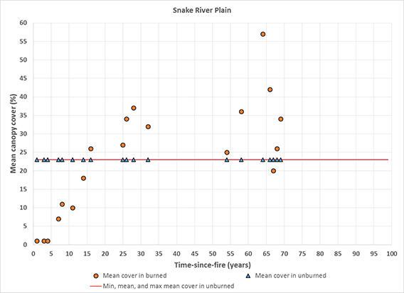
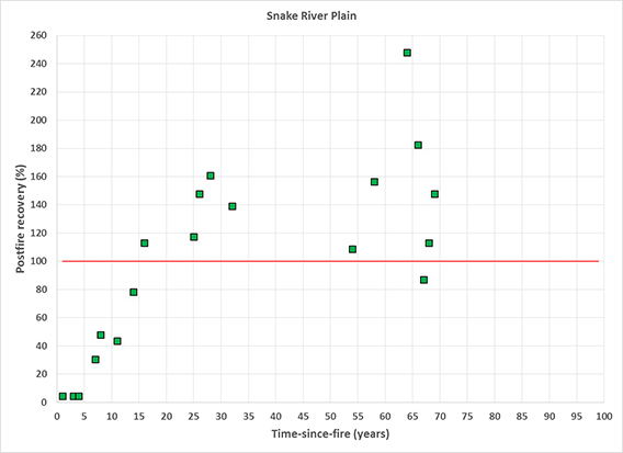
| US Sheep Experiment Station near Dubois, Idaho; 1,690-1,890 m |
Mountain big sagebrush steppe where subdominant shrubs included antelope bitterbrush, yellow rabbitbrush, threetip sagebrush, and spineless horsebrush; herbaceous understory dominated by Sandberg bluegrass, bluebunch wheatgrass, sedge, Idaho fescue, and forbs Sites were lightly to moderately grazed by sheep biannually in spring and fall. |
Compared canopy cover on burned sites, 1-69 years after wild or prescribed fires, to canopy cover (23%) on sites not burned for >70 years | 1%-11% cover 1-8 years after fire 10%-26% cover 11-16 years after fire 27%-37% cover 25-32 years after fire 20%-57% cover 54-69 years after fire Regression analysis showed that mean cover plateaued at 31%, 19 years after fire. |
[225] | |
| Wyoming Basin | |||||
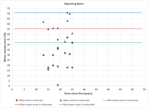
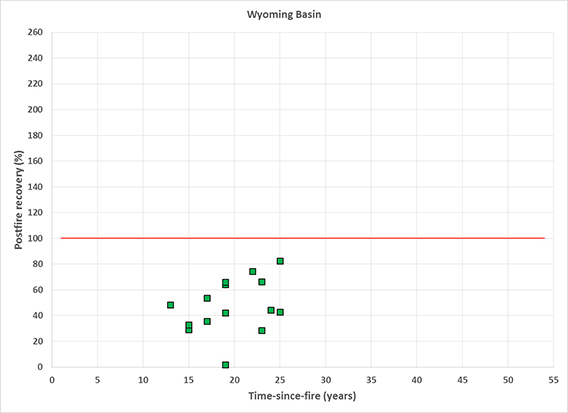
| Carbon County, south of Rawlins, Wyoming; 2,100-2,700 m |
Mountain big sagebrush steppe on moderately deep to deep loamy soils | Compared canopy cover on 6 burned sites (n = 10 plots), 13-25 years after wild or prescribed fires, to canopy cover on 6 paired, unburned sites; and compared canopy cover on 4 additional burned sites (n = 5 plots), 17-19 years after wild or prescribed fires, to average canopy cover on the 6 unburned sites (56%) | 30% cover 13 years after fire (n = 1); 62% cover on unburned site 16%-18% cover 15 years after fire (n = 2); 55% cover on unburned site 1%-37% cover 17-19 years after fire (n = 6); 45%-56% cover on unburned sites 18%-47% cover 22-25 years after fire (n = 6); 42%-71% cover on unburned sites |
[314] | |
| aBaker [19] identified the sagebrush taxa covered in this study as mountain big sagebrush based on elevation and other aspects of the environmental setting. | |||||
| Table A4—Historical fire frequency in mountain big sagebrush landscapes based on analyses of charcoal fragments in soils and sediments, organized by ecoregions. | ||||
| Location; elevation; mean annual precipitation |
Vegetation description | Methods | Fire frequency | Citation |
| Idaho Batholith | ||||
| Wood Creek watershed, southeast of Boise, Idaho; 1,073-1,621 m; 370-570 mm |
Most (93%) of the area was shrublands, with mountain big sagebrush and antelope bitterbrush on xeric, southern aspects and mixed mountain shrublands on mesic, northern aspects. Isolated stands of ponderosa pine and Rocky Mountain Douglas-fir occurred throughout, and willow and cottonwood occurred in riparian areas. Vegetation changed throughout the Holocene; the earliest identifiable occurrence of sagebrush was at ~2,234 cal yr BP, and it appears to have increased over the past 1,400 years. | Radiocarbon dating of charcoal and identification of charcoal macrofossils in alluvial fans and terraces at 8 sites in a 2,600-ha area were used to reconstruct a ~6,000-year history of fire and vegetation. The fire record was compared to independent climate reconstructions to assess relationships between fire and climate over the past 2,000 years. | High fire activity from 2,000 to 1,400 cal yr BP (~50 BC–AD 550)
Low fire activity from ~1300 to 700 cal yr BP (~AD 650–1250) High fire activity from 650 to 300 cal yr BP (~AD 1300–1650), including evidence of 3 to 4 fire events from 600 cal yr BP to present (~AD 1350–1950) |
[233] |
| Middle Rockies | ||||
| Grand Teton National Park, Wyoming; 2,033-2,072 m; ~540 mm |
Swan Lake is surrounded by closed lodgepole pine forest with big sagebrush (probably mountain big sagebrush) steppe and meadows in forest openings. Sagebrush pollen was dominant from ~AD 1430–1575, after which it decreased, but remained present at low concentrations. Lodgepole pine pollen increased and dominated from ~1600–present. | Charcoal from sediment cores was analyzed to calculate charcoal accumulation rates, background charcoal levels (BCHAR), and peaks in charcoal accumulation rates; data were binned in 10-year intervals. Peaks were decades long and considered to be periods of high fire activity consisting of one or more local fires (fire episodes). Pollen from sediment cores was used to reconstruct vegetation history, which was compared to charcoal peaks. Charcoal and pollen records were compared to known climate events (e.g., Medieval Climate Anomaly and Little Ice Age). | Highest BCHAR levels among the 3 sites; BCHAR peaked ~AD 1400 and declined thereafter; 7 fire episodes in 550-year record (1420–1430, 1460–1520, 1550–1560, 1770–1830, 1860–1870, 1920, and 1980–2000) | [140] |
| Hedrick Pond is surrounded by vegetation that is transitional between lodgepole pine forest and big sagebrush steppe. Sagebrush and lodgepole pine pollen were the most common, with similar abundance throughout the 2,100-year record. | Intermediate BCHAR levels that decreased over the last 500 years; 16 fire episodes in 2,100-year record, including 6 episodes in past ~900 years (1060–1150, 1400–1500, 1540–1550, 1740–1750, 1780–1850, and 1980–2000) | |||
| Pothole Lake is surrounded by big sagebrush steppe. Sagebrush pollen was common to abundant throughout the 1,000-year record; it decreased around AD 1300, then increased and dominated until ~1890. Lodgepole pine pollen was abundant from AD 1000 to 1300, then present at lower levels but increasing since ~1900. | Lowest BCHAR levels among the 3 sites; 7 fire episodes in 1,000-year record (1010–1110, 1260–1300, 1390–1450, 1550–1570, 1650–1670, 1760–1810 (with a large peak in 1800), and 1980–2000) | |||
| Northern Yellowstone National Park, Wyoming; 2012 m; 380-420 mm |
Blacktail Pond, a closed kettle lake, is surrounded by big sagebrush (probably mountain big sagebrush) steppe with Rocky Mountain Douglas-fir and lodgepole pine on adjacent, rocky slopes. | Charcoal from sediment cores was analyzed to calculate charcoal accumulation rates, background charcoal levels (BCHAR), and peaks in charcoal accumulation rates; data were binned in 25-year intervals. Peaks were interpreted as one or more local fires (fire episodes). Pollen from sediment cores was used to reconstruct vegetation history, which was compared to charcoal peaks. | Average of: 6 fire episodes/1,000 years from 12,000 to 11,000 cal yr BP 4 fire episodes/1,000 years at 10,500 cal yr BP 8 fire episodes/1,000 years at 8,500 cal yr BP 6 fire episodes/1,000 years from 8,500 to 2,000 cal yr BP 3 fire episodes/1,000 years from 2,000 cal yr BP to ~AD 1950 Two large fire episodes occurred between 11,000 and 10,000 cal yr BP; other large fire episodes occurred at 6,750, 3,400, 2,950, 2,850, 2,550, 1,800, and 1,550 cal yr BP. |
[137] |
| Table A5—Historical mean fire intervals (MFIs) based on fire-scar records, organized by ecoregions. | |||||
| Location; elevation; mean annual precipitation |
Vegetation description | Methods | Fire frequency | Citation(s) | |
| Central Basin and Range, Colorado Plateaus, and Wasatch and Uinta Mountains | |||||
| Throughout Utah and eastern Nevada; 1,858-2,810 m; 497-552 mm |
Mountain big sagebrush steppe intermixed with various forest types | Samples consisted of 190 cross-dated, fire-scarred trees, stumps, and logs: primarily ponderosa pine, and occasionally Rocky Mountain Douglas-fir, pinyon, limber pine, and Rocky Mountain juniper.
Samples were located in 0.5-ha (40-m radius) plots at 9 sites in 3 site types: 1) within mountain big sagebrush communities (embedded chronologies) (2 sites, n = 7 plots), 2) within 10 m of the forest-steppe ecotone (ecotonal sites) (6 sites, n = 10 plots), and 3) on opposite sides of mountain big sagebrush communities (two-sided chronologies) (4 sites, n = 5 plots). Fire intervals for individual plots were treated as point fire intervals and recorded from both individual samples and "constrained composites" using 2-16 samples. Point MFIs were calculated as the average of the number of years between successive fires in each plot during the entire period of record. Presettlement MFIs were calculated by dividing the number of years between the first recorded fire and 1850 by the number of fires recorded during that time. The dates of the last fire recorded varied among plots, occurring before (5 of 22 plots), during (12 of 22 plots), and after (5 of 22 plots) the settlement period (1850 to 1910). |
Point MFIs for the entire record (1341–1999) by site type:
|
[159] | |
Presettlement MFIs by site type:
|
[160] | ||||
| Eastern Cascades Slopes and Foothills and Northern Basin and Range | |||||
| Cabin Lake, Deschutes National Forest, near La Pine, Oregon; 1,190 m; 240 mm |
Ponderosa pine/antelope bitterbrush-big sagebrush (probably mountain big sagebrush)/Idaho fescue steppe with sparse fuels on moderately deep (71-91 cm), well-drained pumice soils | Tree-ring chronologies were examined on 5 ponderosa pine trees in each of 6, 16-ha plots and 1 scarred snag; a total of 45 fires were recorded from 1460–1900. Composite MFI was calculated for the period 1600–1900. Fire suppression began in 1910, but fire frequency did not decrease afterwards; 16 fires occurred between 1910 and 1981. |
Site composite MFI: 7 years
Plot composite MFI: 24 years; range: 16-38 years Point MFI range: 4-100 years |
[48] | |
| Hart Mountain National Antelope Refuge, Oregon; elevation and mean annual precipitation not provided |
Mountain big sagebrush/Idaho fescue steppe with <4% western juniper cover, on deep soils of volcanic origin | Nine fires were recorded from 1760–1861 on 1 fire-scarred ponderosa pine tree and 1 stump within a ~20-ha site. Nearly all trees were cut in the late 1860s, limiting fire-scar samples; however, no fires were recorded on the 2 samples after 1861. |
Composite MFI: 13 years; range: 3-32 years | [117] | |
| Southeastern and south-central Oregon and northeastern California; elevation and mean annual precipitation not provided |
Mountain big sagebrush/Idaho fescue steppe communities with intermixed and adjacent ponderosa pines; western junipers were establishing and spreading on several sites | Composite MFIs were calculated for 10 sites based on cross-dated fire scars from 3-5 ponderosa pine trees in 1-ha clusters; 1-3 clusters were sampled at each site, for a total of 14 clusters. About 200 fire scars were dated, and presettlement chronologies began between 1600 and 1830 and ended in 1870. Settlement began in the 1860s; only 6 of 10 sites recorded fires from 1900–1950, and no fires were recorded on any site after 1950. |
Composite MFIs ranged from 6.2-17.3 years; the site with the shortest MFI was on a long ridge above a high-elevation tableland, exposing it to frequent lightning strikes.
Minimum fire interval range: 3-12 years Maximum fire interval range: 10-32 years |
[220] | |
| Upper Chewaucan River basin near Paisley, Oregon; lower montane zone, 1,450-1,875 m; 400 mm |
Mountain big sagebrush/Idaho fescue communities on moderately deep soils with varying density of western juniper and scattered, small clusters of ponderosa pine | Composite MFIs were calculated from intervals on 3 trees in each of 3 "small" clusters of ponderosa pine trees, and a point MFI was calculated from intervals on 1 tree in a 4th cluster. The size of the clusters was not provided. The fire record included 33 fires from 1601–1897.
Livestock were introduced in the late 1860s and fire suppression began in 1908. No large fires occurred after 1870, and no fires occurred from 1898–1996. |
Composite MFIs within individual clusters were 12, 12, and 15 years, with a range of 3-28 years between fires; the point MFI in the remaining cluster was 27 years, with a range of 12-54 years between fires.
The composite MFI for the study area as a whole (5,000 ha) was 7.7 years (range: 1-19 years). Seven fires were recorded in 3 or 4 clusters and interpreted as "large" or "extensive" fires. |
[214] | |
| Middle Rockies | |||||
| Near Wise River, Montana; 1,900-2,225 m; 300 mm |
Mountain big sagebrush-grasslands intermixed with Rocky Mountain Douglas-fir savanna | Composite MFI for the period 1700–1860 was based on 78 fire-scarred Rocky Mountain Douglas-fir and 5 fire-scarred lodgepole pine trees, logs, snags, and stumps sampled on a 1,030-ha site. Settlement began in the mid-1850s and only 1 fire was recorded after 1860. |
Composite MFI: 37 years; range: 2-84 years | [126] | |
| Northern Yellowstone National Park, Wyoming; 1,500-2,600 m; 395 mm |
Montane grassland steppe adjacent to and intermixed with mountain big sagebrusha steppe and Rocky Mountain Douglas-fir communities | Point MFIs were calculated from fire scars on 34 live and 8 dead Rocky Mountain Douglas-firs on 7 sites; fire dates ranged from 1485–1970; presettlement point MFIs were estimated for the period ending in 1890.
Composite MFIs were calculated from cross-dated fire scars on 13 live Rocky Mountain Douglas-firs from forest-steppe ecotones in 6 stands (2-3 trees/stand) within 4 of the 7 sites; fire dates ranged from 1603–1970; presettlement MFIs were calculated by excluding the interval from 1970 to the most recent scar in each stand. The most recent fire scar recorded in each of the 6 stands occurred between 1820 and 1900. |
Mean point MFI: 32-70 years, among 7 sites
Composite MFI: 17-41 years, among 6 stands By excluding the lowest and highest composite MFIs, the author suggested that the "best estimate of the true fire frequency" was 20-25 years. |
[135] | |
| Southwestern Montana and adjacent Idaho; 1,680-2,130 m; mean annual precipitation not provided |
Grassland steppe adjacent to and intermixed with mountain big sagebrush and Rocky Mountain Douglas-fir communities on loams; historical photographs from the 1930s indicated that mountain big sagebrush and Rocky Mountain Douglas-fir increased in cover and density during the subsequent ~50 years. | Point and composite MFIs were calculated from fire scars on (primarily) Rocky Mountain Douglas-fir trees, snags, and stumps at 12 sites with evidence of past surface fires; point MFIs were calculated for 1 tree on each of 8 sites, and composite MFIs were calculated on 4 sites, based on scars from 2 trees per site. Fire dates ranged from 1554–1902. Organized fire suppression began in 1910; only 1 of the 12 sites had a fire recorded after 1910. |
Composite MFIs on cool, moist Rocky Mountain Douglas-fir/pinegrass: mean: 41 years; range: 22-58 years; range of point MFIs: 5-97 years
Composite MFIs on cool, dry Rocky Mountain Douglas-fir/Idaho fescue: mean: 45 years; range: 31-60 years; range of point MFIs: 6-94 years The above estimates were adjusted to 35-40 years by adding a fire to each chronology, based on the assumption of probable missing fire scars. |
[13] | |
| aBaker [19] identified the sagebrush taxa covered in this study based on elevation and other aspects of the environmental setting. | |||||
| Table A6—Historical fire rotation estimates in mountain big sagebrush steppe based on General Land Office (GLO) survey recordsa and fire indicators on contemporary landscapes, organized by ecoregions. | |||
| Total area, vegetation, location, and proportion of total area burned | GLO survey date | Fire rotation (years) | Citation |
| Central Basin and Range | |||
| 48,016 ha of mountain big sagebrush steppe in northeastern Nevada; 17% identified as burned areasb | ~1868–1910 | 130-207 | [60] |
| Colorado Plateaus | |||
| An unknown area of mountain big sagebrush steppe in Dinosaur National Monument (52,936 ha) and surrounding areas (245,027 ha) in Colorado and Utah; percent burned area not reported | 1904–1911; the area was "relatively unsettled" until the 1920s | 458-729 | [11] |
| Colorado Plateaus and Southern Rockies | |||
| 79,565 ha of mountain big sagebrush steppe in west-central Colorado; 20% identified as burned areasb | 1872–1892 | 90-143 | [59] |
| Eastern Cascades Slopes and Foothills and Northern Basin and Range | |||
| 14,966 ha of mountain big sagebrush steppe in southern Oregon; 46% identified as burned areasb | ~1868–1910 | 48-77 | [60] |
| Middle Rockies and Snake River Plain | |||
| 105,671 ha of mountain big sagebrush steppe in southeastern Idaho; 20% identified as burned areasb | ~1868–1910 | 110-175 | [60] |
| Wyoming Basin | |||
| 71,423 ha of mountain big sagebrush steppe in southwestern Wyoming; 4% identified as burned areasb | ~1868–1910 | 588-2,139 | [60] |
| aSection-line descriptions from survey records were used to reconstruct historical vegetation and identify areas thought to have burned; these areas were then used to estimate fire rotations. bBurned areas included both "non-ambiguous" and "ambiguous" burns. Burns identified by the presence of postfire successional vegetation (e.g., those dominated by grasses and/or low-density sagebrush) and various other fire indicators were considered non-ambiguous. Ambiguous burned areas included grasslands "if context and modern vegetation data did not provide sufficient evidence for either including or excluding the patch as a potential fire" [59,60]. |
|||
| Table A7—Historical fire frequency estimates for stand-replacing fires in pinyon-juniper communities with mountain big sagebrush understories, organized by ecoregions. | ||||
| Location; elevation; mean annual precipitation |
Vegetation description | Methods | Fire frequency estimate | Citation(s) |
| Central Basin and Range | ||||
| 840 ha in the Barrett Canyon watershed, Shoshone Mountain Range, central Nevada; ~2,100-2,900 m; ~230-500 mm |
Singleleaf pinyon-curlleaf mountain-mahogany woodlands with a sparse understory of Wyoming big sagebrush, mountain big sagebrush, green ephedra, mountain snowberry, and Sandberg bluegrass on welded and unwelded tuff | Time-since-fire was estimated via systematic sampling of woodland structure and fire evidence in 90 plots across the watershed in stands with >10% tree cover; survivorship models using plot stand ages were used to calculate fire cycle. | 650-year fire cycle (P < 0.0001) from 1300–2004, with no fires after 1880 447-year fire cycle (P = 0.05) 1300–1880 |
[33,34] |
| Colorado Plateaus | ||||
| 2,230 ha of the Kaiparowits Plateau, Glen Canyon National Recreation Area, Utah; 2,180-2,292 m; 294-317 mm |
Colorado pinyon-western juniper/mountain big sagebrush-Wyoming big sagebrush woodlands with a sparse understory on shallow, sandy loamsa | Time-since-fire was estimated from stand age and structure and evidence of past fire in 18 randomly selected young (<300 years old) and old-growth (>300 years old, up to 600 years old) stands and 7 subjectively selected old-growth stands. Fire rotation was calculated as the total time period divided by the proportion of the study area with evidence of fire. Nearly all burned areas appeared to have burned prior to 1900. Cattle grazing occurred on the plateau throughout the 20th century. |
600+ year fire rotation for ~1700–2000 (based on evidence that ~50% of the study area had burned during those 300 years)
~400-year fire rotation for ~1700–1900 (based on evidence that ~50% of the study area had burned during those 200 years) These estimates were combined to yield a fire rotation estimate of 400-600+ years. |
[99] |
| 240,000 ha of the Uncompahgre Plateau of southwestern Colorado; 1,800-2,300 m; ~200 to >400 mm |
Colorado pinyon-Utah juniper woodlands and savannas with mixed mountain shrub, black sagebrush, Wyoming big sagebrush, mountain big sagebrush, and basin big sagebrush understories, intermixed with grasslands, black sagebrush, and Wyoming big sagebrush communities | Time-since-fire was estimated from stand age, density, structure, composition, and evidence of past fires in 56 stands. Stands were classified as young stands if they were <300 years old. Fire rotation was calculated as the total time period divided by the proportion of stands burned during that period. European–American settlement in the area began in 1881, followed by a period of heavy livestock grazing that persisted until the 1940s, followed by regionally extensive clearing of woodlands to increase livestock forage. |
~526-year fire rotation estimated for young stands (n = 14) (assuming that 57% of stands originated after fire during a 300-year period, 1700–2000)
~580-year fire rotation estimated for all stands (n = 56) (assuming that 86% of stands originated after fire during a 500-year period, 1400–1900) ~610-year fire rotation estimated for randomly selected stands (n = 28) (assuming that 82% of stands originated after fire during a 500-year period) The fire rotation estimates were modified to ~400-600 years because exact fire dates were unknown, some stand ages may have been underestimated, some stands may not have initiated after fire, and some stands may have burned more than once. |
[278] |
| Southern California Mountains | ||||
| 87,000 ha in the San Bernardino Mountains, California; 1,300-2,700 m; 250-400 mm |
Singleleaf pinyon-California juniper-western juniper/mountain big sagebrush woodlands with a sparse herbaceous understorya | Thirty-eight burned areas covering about 15,000 ha were identified using aerial photographs from 1938 and fire perimeter data for 1911–1993 from the San Bernardino National Forest. Fire rotation was calculated as the total time period divided by the proportion of area burned in that period. | ~480-year fire rotation (17% of the study area burned during the 82-year period, 1911–1993) | [313] |
| aBaker [19] identified the sagebrush taxa covered in this study based on elevation and other aspects of the environmental setting. | ||||
| Column I—Mean canopy cover on burned sites versus time-since-fire (circles) and paired mean canopy cover on nearby, unburned sites (triangles) in eight ecoregionsa. Lines show the minimum, mean, and maximum values of mean canopy cover in unburned sites used to represent full recovery in our analyses. | Column II—Ratio of burned to unburned (or prefire) canopy cover (i.e., "postfire recovery") of mountain big sagebrush versus time-since-fire in eight ecoregionsa. The red line shows 100% recovery. Squares above the red line are fully recovered, those below are not. |
| I) Canopy cover over time | II) Recovery over time |
| a) Snake River Plain | |
 |
 |
| b) Middle Rockies | |
 |
 |
| c) Wyoming Basin | |
 |
 |
| d) Eastern Cascades Slopes and Foothills | |
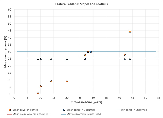 |
 |
e) Northern Basin and Range |
 |
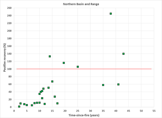 |
| f) Central Basin and Range | |
 |
 |
| g) Wasatch and Uinta Mountains | |
 |
 |
| h) Colorado Plateaus | |
 |
 |
| aEcoregions are based on Level III ecoregion classifications for the conterminous United States [240,295]. Data on mountain big sagebrush canopy cover and postfire recovery comes from these sources by ecoregion: a) Snake River Plain [225], b) Middle Rockies [3,4,5,6,100,136,184,199,303,306,310], c) Wyoming Basin [314], d) Eastern Cascades Slopes and Foothills [121,358], e) Northern Basin and Range [90,134,196,358], f) Central Basin and Range [234], g) Wasatch and Uinta Mountains [109,234], and h) Colorado Plateaus [234]. | |