| FEIS Home Page |
Common names of plant species are used throughout this in summary. For a complete list of the common and scientific names of plant species discussed in this summary and for links to species density graphs and FEIS reviews, see the Appendix.
MANAGEMENT PROJECT SUMMARY CITATION:Sources: Unless otherwise indicated, the information in this Management Project Summary comes from previously unpublished data and the following paper:
Reemts, Charlotte M.; Hansen, Laura L. 2008. Slow recolonization of burned oak-juniper woodlands by Ashe juniper (Juniperus ashei): ten years of succession after crown fire. Forest Ecology and Management. 255(3-4): 1057-1066 [4].
PROJECT DESCRIPTION: |
| Figure 1. Location of the wildfires. |
Site description and condition:
The burned area is in somewhat dissected terrain and includes lowlands, slopes (all aspects), and mesa tops. Elevation ranges from 235 to 300 meters above sea level. Climate is humid subtropical. Average high temperature in August is 36ºC; average high temperature in January is 14ºC. Average annual precipitation is 838 mm, with two rainy seasons (May-June and October).
Fire effects were studied on three soil types (a detailed description of the study design and methods can be found Reemts and Hansen [4]. Evant soils are found on rolling hills, with slopes generally less than 10 degrees. These are the deepest soils studied, with depths from 36 to 51 cm. Eckrant soils are shallow (10 to 51 cm deep, but usually less than 30 cm) and found on flat, rocky limestone mesa tops. Real soils are found on slopes and slope shoulders, usually downslope from Eckrant soils. Slopes can be as steep as 45 degrees but are usually 10-20 degrees. Soil depths range from 20 to 48 cm (usually less than 30 cm).
The study area was wooded before the fires and was essentially unmanaged. Military training is confined to large grassy openings in the woodlands and to roads within the woodlands. The area is grazed, but the natural understory of the woodlands is very sparse and cattle generally only use the woodlands for cover.
The February 1996 wildfire was preceded by 3 years of approximately average rainfall (800 mm/yr; Figure 1). Rainfall following the fire was average to above average. The April 2009 wildfire occurred in a year of above-average rainfall, but was preceded and followed by droughts.
 |
| Figure 2. Total annual precipitation from 1990 to 2011 for the study area. The wildfires are marked with red dashed lines. |
Treatment descriptions:
After the first wildfire, transects were randomly located in moderately to severely burned areas. These transects were sampled every summer from 1996 to 2002, and again in 2005 and 2010. The second wildfire re-burned some of these transects; these twice-burned transects were sampled each summer from 2009 to 2011. In this report, the first summer after each fire is identified as “postfire year 0”; thus, transects were measured in postfire years 0-6, 9, and 14 after the 1st fire and in postfire years 0-2 after the 2nd fire. Control (unburned) transects were selected in areas adjacent to the wildfires on similar soils, slopes, and aspects. Unburned transects were sampled in 2001, 2005, and 2010. The table below may be helpful for relating calendar years to postfire years.
| Table 1. Fire years. | ||
| Year | ||
| After 1st fire | After 2nd fire | |
| 1996 | 0 | |
| 1997 | 1 | |
| 1998 | 2 | |
| 1999 | 3 | |
| 2000 | 4 | |
| 2001 | 5 | |
| 2002 | 6 | |
| 2005 | 9 | |
| 2009 | 13 | 0 |
| 2010 | 14 | 1 |
| 2011 | 15 | 2 |
On Evant soils, the community was a post oak-Ashe juniper woodland. Blackjack oak is present but uncommon. The shrub layer is diverse and includes Texas ash, eastern poison-ivy, saw greenbrier, gum bumelia, stretchberry, and possumhaw. Canopy cover was generally above 50% but varied greatly. The understory beneath the trees is generally sparse (~5%); cedar-sedge (Carex planostachys) is the most common species. In canopy openings, additional grass species include threeawns, dropseeds, sideoats grama, and Texas wintergrass. Historically, these communities were likely post oak savannas that have since been invaded by Ashe juniper to form woodlands.
Eckrant soils are dominated by bastard oak-Ashe juniper woodlands or shrublands. Other common canopy species include Texas ash, Texas live oak, and Buckley's oak. The shrub layer includes mescal bean, eastern poison-ivy, stretchberry, Texas redbud, saw greenbrier, evergreen sumac, sweet mountain grape, possumhaw, Texas persimmon, and gum bumelia. Canopy cover was generally above 50%, with bare patches around bedrock outcrops. Understory cover is sparse (~5%) and confined largely to openings in the canopy. Common species include cedar-sedge, composite dropseed, and rosette grasses. Historically, these soils supported a mix of bastard oak shrublands and oak-juniper woodlands, depending on the local fire history and soil depth.
Community composition on the Real soils is somewhat more variable. On drier slopes, Buckley's oak and Ashe juniper codominate; Texas ash is also common. On mesic slopes, Ashe juniper becomes less dominant, and the deciduous component becomes more diverse. Additional species include chinquapin oak, hackberries, and walnuts. The shrub layer includes eastern poison-ivy, sweet mountain grape, Texas redbud, saw greenbrier, Carolina buckthorn, mescal bean, Spanish grape, dewberry, Texas persimmon, and possumhaw. Canopy cover is generally above 75% with openings around bedrock outcrops. Understory cover is sparse (~5%) and includes cedar-sedge and rosette grasses. Woodlands on these slopes are generally similar to those found historically.
The woodlands are surrounded by grasslands and oak savannas. On Evant soils, savannas are dominated by post oak, while Texas live oak is dominant on most other soils. Grasslands were historically dominated by little bluestem and sideoats grama; yellow bluestem is codominant to dominant in most areas.
Fuels:
Little information was available about fuels in these woodlands at the time of the wildfires.
Historical fire regime:
Study sites are classified in the following plant community and probably historically experienced the fire regime described below:
| Table 2. Fire regime information on the vegetation community studied in this Research Project Summary. Fire regime characteristics are taken from the LANDFIRE Rapid Assessment Vegetation Model [3]. This vegetation model was developed by local experts using available literature and expert opinion as documented in the PDF file linked from the Potential Natural Vegetation Group listed below. Cells are blank where information is not available in the Rapid Assessment Vegetation Model. | |||||
| Vegetation Community (Potential Natural Vegetation Group) | Fire severity* | Fire regime characteristics | |||
| Percent of fires | Mean interval (years) |
Minimum interval (years) |
Maximum interval (years) |
||
| Oak woodland-shrubland-grassland mosaic | Replacement | 11% | 50 | ||
| Mixed | 56% | 10 | |||
| Surface or low | 33% | 17 | |||
| *Fire Severities: Replacement=Any fire that causes greater than 75% top removal of a vegetation-fuel type, resulting in general replacement of existing vegetation; may or may not cause a lethal effect on the plants. Mixed=Any fire burning more than 5% of an area that does not qualify as a replacement, surface, or low-severity fire; includes mosaic and other fires that are intermediate in effects. Surface or low=Any fire that causes less than 25% upper layer replacement and/or removal in a vegetation-fuel class but burns 5% or more of the area [1,2]. |
|||||
| Table 3. Fire descriptions. | ||||
| Year | Season | Overall severity | Vegetation* | Substrate* |
| 1996 | winter (February 2 – March 7) |
mixed-severity crown fire | 50% severely burned 35% moderately burned |
20% severely burned 70% moderately burned |
| 2009 | spring (April 3 - 12) |
mixed-severity crown fire | 30% moderately burned 50% lightly burned |
45% moderately burned 45% lightly burned |
| *Transects were located ONLY in moderately to severely burned areas following the 1996 fire. Fire severity was measured in 7 plots along each transect using National Park Service methods [5]. Monitoring in 2009 was done on the same transects used following the 1996 fire. | ||||
Plant Phenology:
The 1996 fire occurred before most species had leafed out. The 2009 fire occurred shortly after most species had leafed out.
Wildfire effects:
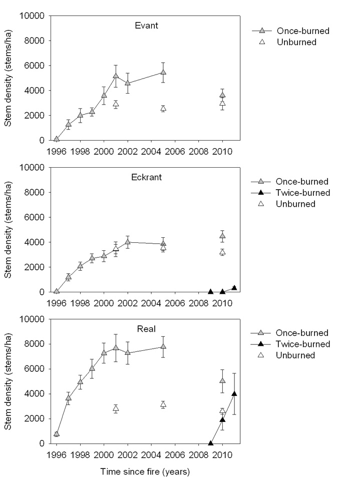
The first wildfire had relatively small effects on understory density (stems ≤ 1.8 m tall) but much larger effects overstory density (stems > 1.8 m tall). On Evant soils, understory stem density returned to unburned levels by 2001 (postfire year 5) and was higher than unburned levels through 2010 (postfire year 14, Figure 3). Understory density on Eckrant and Real soils in postfire year 14 was only slightly less on burned than unburned transects. The overstory on all soils was almost eliminated by the first wildfire, at least initially (Figure 4). On Evant and Eckrant soils, overstory density returned to unburned levels by postfire year 5 and, at least on Evant soils, continued to increase. On the more mesic Real soils, overstory density was similar to unburned levels by postfire year 2 and had more than doubled by postfire year 4. Even though overstory density has recovered to (or increased over) unburned levels, basal area is still much lower than in the unburned areas (Evant: 3 m²/ha vs. 23 m²/ha; Eckrant: 1 m²/ha vs. 17 m²/ha; Real: 3 m²/ha vs. 18 m²/ha).
Stem density response in both the under- and overstory differed greatly between the first and second fires. On both Eckrant and Real soils, twice-burned understory density in 2009 (the summer after the second fire) was about three times as high as in 1996 (the summer after the first fire) (Figure 3). Density decreased in each of the following years, but, at least on Eckrant soils, remained higher than both once-burned and unburned density. Overstory density, on the other hand, recovered more slowly (Figure 4). Recovery after the second fire lagged about a year behind recovery after the first fire. Thus in 2011 (year 2 after the 2nd fire), twice-burned overstory stem density on Real soils was similar to once-burned density in 1997 (year 1 after the 1st fire). On Eckrant soils, no overstory stems were found in the first two summers after the second fire; density in 2011 (year 2 after the 2nd fire) was 85% lower than it had been in 1999 (year 2 after the 1st fire).
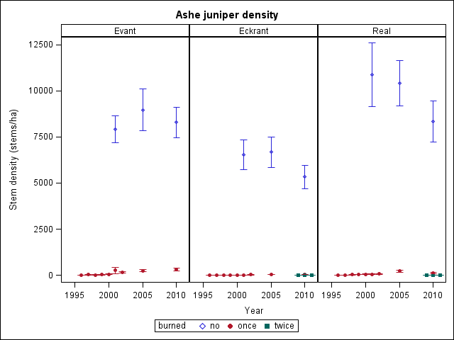
Most species present in unburned transects were also present in the postfire communities because the majority of woody species in these woodlands regenerate after fire by sprouting. Notable exceptions include Ashe juniper, which does not sprout; and Rooseveltweed and prairie sumac, which sprout but also colonize burned areas from seed. Although the dominant oak species have remained the same, the codominant Ashe juniper has recovered very slowly. In year 14 after the first fire, stem density was still less than 5% of that in unburned communities.
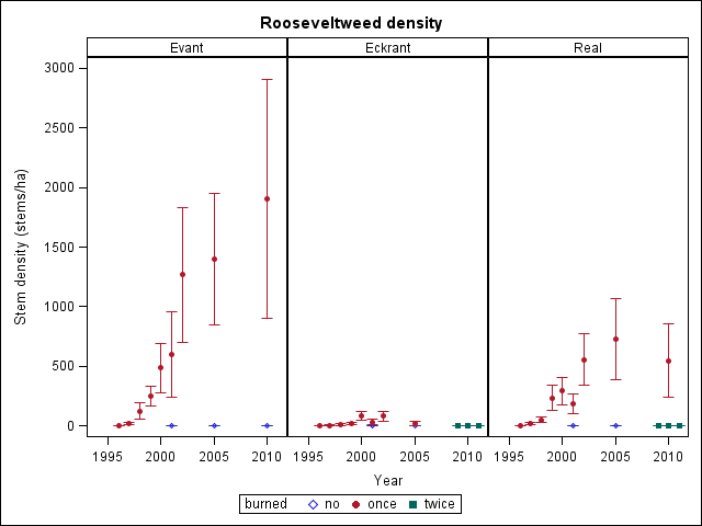
After the first wildfire, most species on all three soils types increased in density for the first three growing seasons (Evant: 65% of species; Eckrant: 43%; Real: 63%; Table 2), but their density later declined (Evant: 35%; Eckrant: 46%; Real: 32%). These are identified in table 2 as species that “peaked”. After the second wildfire, many species decreased in density for the first three growing seasons (Eckrant: 37%; Real: 44%). Bastard's oak density, for example, increased in the 3 summers after the first fire on Evant and Real soils but later declined (see appendix for species density graphs). After the second fire on Eckrant and Real soils, bastard oak density declined. Rooseveltweed density increased in the 3 summers after the first fire on all three soil types, although it was not present in 1996 on any soil (and is also absent from most unburned transects). In year 14 after the first fire, density in the once-burned areas had peaked on Eckrant and Real soils but was continuing to increase on Evant soils. Rooseveltweed is still absent from twice-burned areas. Chinaberrytree, the most common non-native woody species found in the study area, was usually absent from Evant and Eckrant soils. On Real soils, it increased after the first fire but was absent after the second. (It was present in only one of the twice-burned transects before the second fire.)
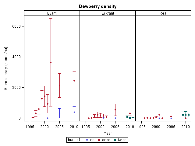
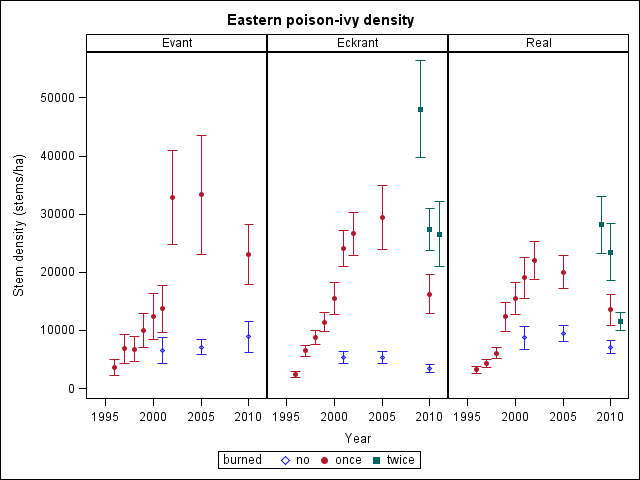
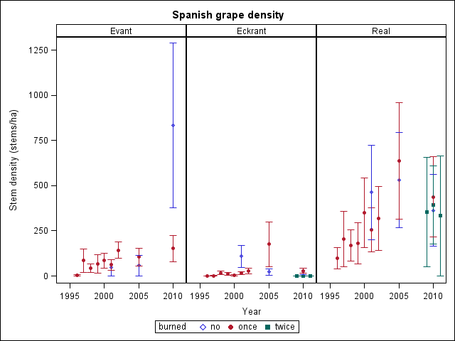
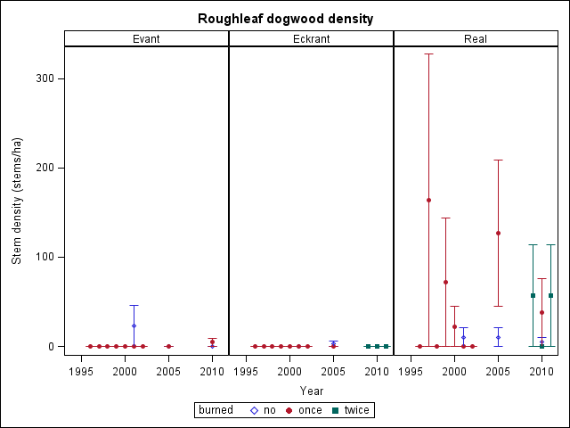
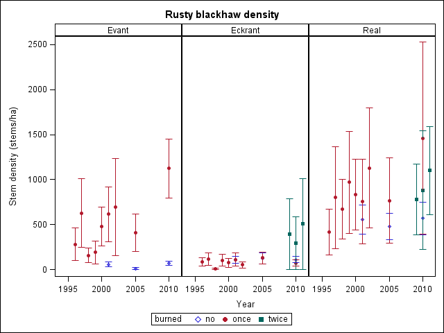
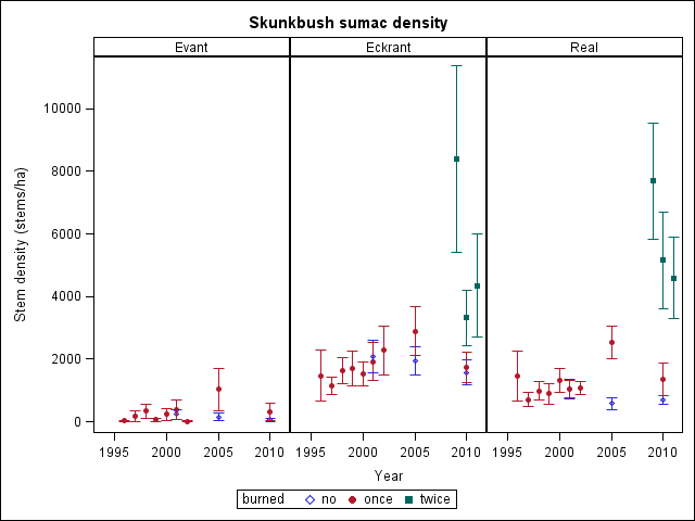
While most species' density in the once-burned areas returned to unburned levels in the 14 years studied, a few species still had much higher stem density than in unburned areas. On Evant soils, these species include cedar-elm, dewberry, eastern poison-ivy, possumhaw, Rooseveltweed, and saw greenbrier; on Eckrant soils, they include eastern poison-ivy, paleleaf yucca, and pricklypears; and on Real soils, they include paleleaf yucca, saw greenbrier, and sweet mountain grape. After the second wildfire, most species' density declined; notable exceptions include the pricklypears and saw greenbrier, which continued to increase in density, particularly on Eckrant soils .
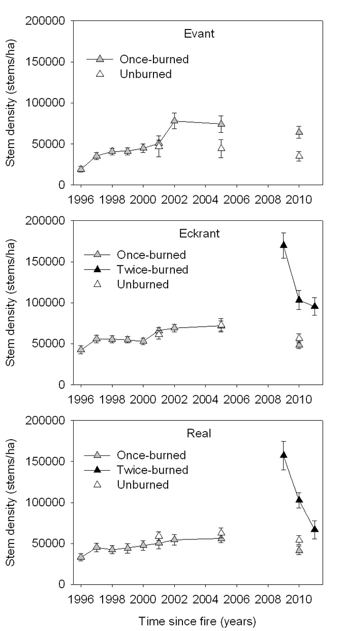 |
| Figure 3. Average understory (stems <1.8 m tall) stem density from once-burned (1996), twice-burned (1996 and 2009), and unburned transects. Data were not collected every year. No transects on Evant soils were burned in the second fire. |
 |
| Figure 4. Average overstory (stems >1.8 m tall) stem density from once-burned (1996), twice-burned (1996 and 2009), and unburned transects. Data were not collected every year. No transects on Evant soils were burned in the second fire. |
| Table 4. Density response after crown fires in oak-juniper woodlands. Species responses for the 1st fire were analyzed for all years,
and also for 1996 to 1998 (years 0-2). Species responses for the 2nd fire are analyzed for 2009 to 2011 (years 0-2). absent = Absent after fire (if in parentheses, that species was not found in the twice-burned transects even before the fire, but was found in other transects on that soil). decreasing = Density decreases continuously; dip = density initially decreases and then increases. increasing = Density increases continuously; peak = density increases and then later decreases. -- = Species not found on that soil type or is too uncommon to determine a response. italics = Absent for first 1-2 years after fire. bold = Species response after 2nd fire is opposite that after 1st fire (years 0-2). |
|||||||
| (all years) | (years 0-2) | (all years) | (years 0-2) | (years 0-2) | (all years) | (years 0-2) | |
| algerita | -- | -- | increasing | absent | (absent) | -- | -- |
| Ashe juniper | increasing | variable | increasing | increasing | absent | peak | increasing |
| bastard oak | peak | increasing | decreasing | variable | decreasing | peak | increasing |
| black prairie clover | -- | -- | increasing | increasing | absent | -- | -- |
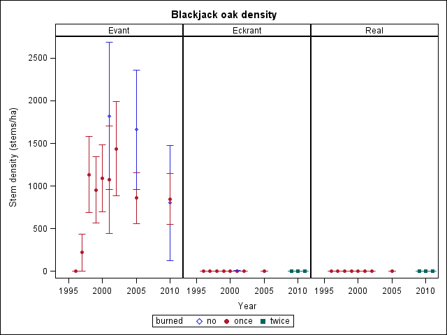
| blackjack oak | peak | increasing | -- | -- | -- | -- | -- |
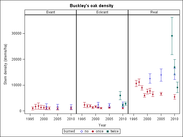
| Buckley's oak | variable | increasing | dip | decreasing | decreasing | decreasing | decreasing |
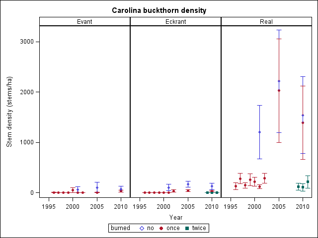
| Carolina buckthorn | -- | -- | -- | -- | -- | increasing | variable |
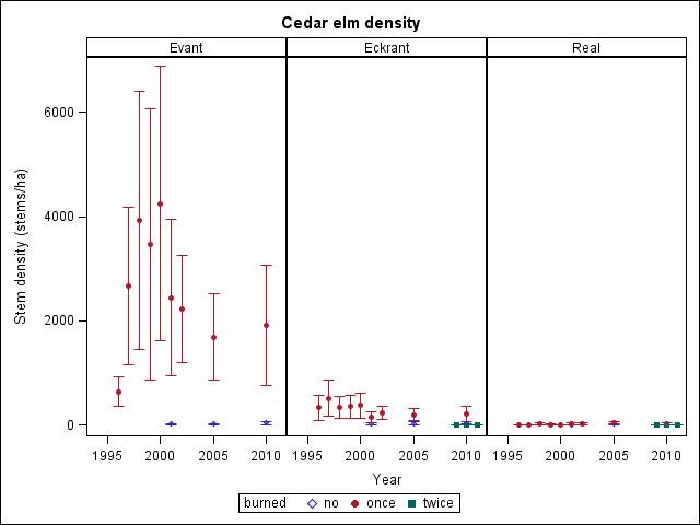
| cedar-elm | variable | increasing | dip | variable | (absent) | peak | increasing |
| Chinaberrytree | -- | -- | -- | -- | -- | increasing | increasing |
| chinkapin oak | -- | -- | -- | -- | -- | variable | variable |
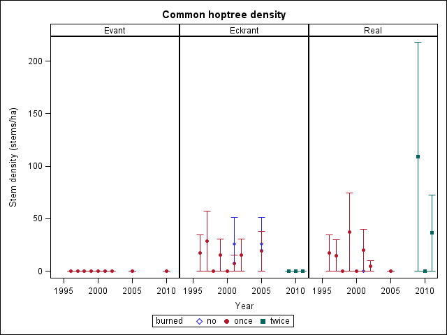
| common hoptree | -- | -- | variable | variable | absent | variable | decreasing |
| dewberry | peak | increasing | peak | increasing | variable | variable | variable |
| eastern poison-ivy | peak | increasing | peak | increasing | decreasing | peak | increasing |
| Eve’s necklacepod | peak | variable | variable | variable | absent | variable | increasing |
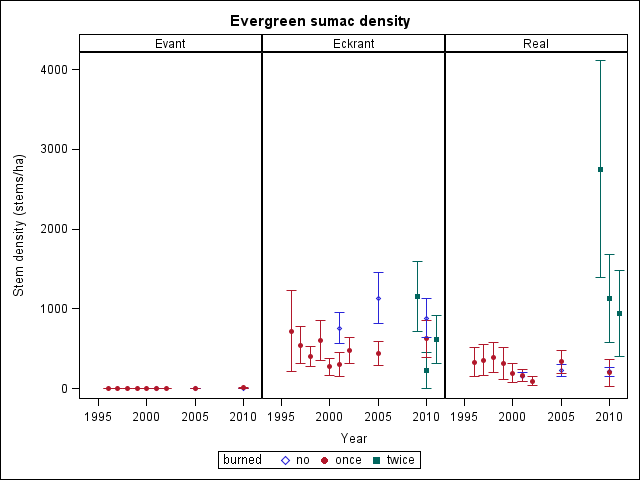
| evergreen sumac | -- | -- | peak | decreasing | variable | variable | increasing |
| gum bully | variable | increasing | variable | increasing | variable | peak | increasing |
| Jersey tea | -- | -- | -- | -- | -- | variable | increasing |
| mescal bean | -- | -- | peak | increasing | decreasing | peak | variable |
| Mexican plum | -- | -- | -- | -- | -- | variable | variable |
| mustang grape | peak | increasing | -- | -- | -- | peak | absent |
| netleaf hackberry | variable | increasing | dip | variable | variable | variable | increasing |
| plums | -- | -- | peak | increasing | absent | -- | -- |
| possumhaw | dip | increasing | variable | variable | variable | peak | decreasing |
| post oak | dip | decreasing | -- | -- | -- | -- | -- |
| prairie sumac | peak | increasing | peak | increasing | decreasing | variable | variable |
| pricklypear | increasing | increasing | increasing | increasing | increasing | peak | increasing |
| Rooseveltweed | increasing | increasing | peak | increasing | absent | peak | increasing |
| roughleaf dogwood | -- | -- | -- | -- | -- | variable | variable |
| rusty blackhaw | increasing | variable | variable | decreasing | variable | increasing | variable |
| saw greenbrier | increasing | increasing | increasing | increasing | increasing | increasing | increasing |
| sevenleaf creeper | -- | -- | peak | variable | decreasing | peak | increasing |
| skunkbush sumac | variable | increasing | peak | variable | decreasing | variable | variable |
| sorrelvine | -- | -- | variable | variable | absent | -- | -- |
| Spanish grape | peak | variable | peak | increasing | (absent) | peak | variable |
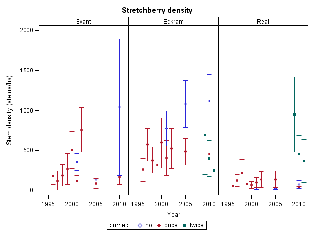
| stretchberry | variable | variable | variable | variable | decreasing | variable | increasing |
| sweet mountain grape | variable | decreasing | peak | decreasing | variable | increasing | increasing |
| sycamoreleaf snowbell | -- | -- | -- | -- | -- | variable | increasing |
| Texas ash | variable | increasing | peak | variable | decreasing | variable | increasing |
| Texas Hercules'-club | -- | -- | variable | decreasing | decreasing | dip | increasing |
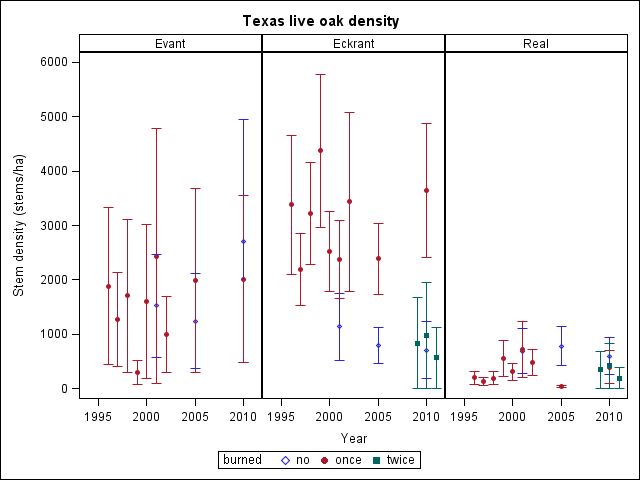
| Texas live oak | variable | variable | variable | variable | variable | variable | variable |
| Texas mulberry | -- | -- | -- | -- | -- | variable | increasing |
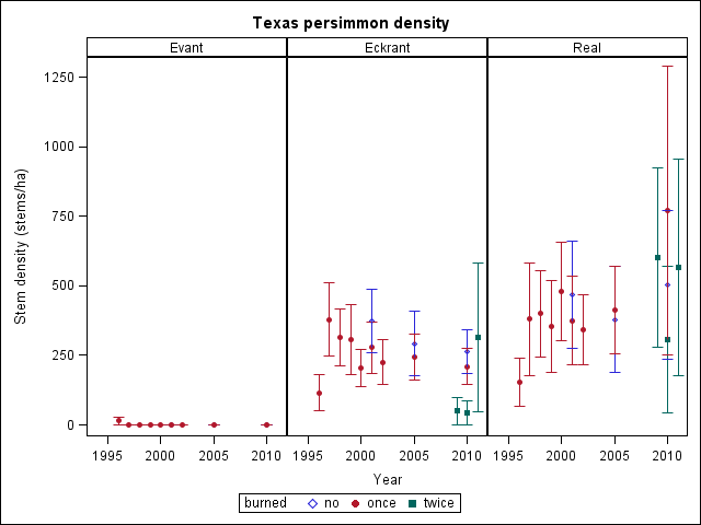
| Texas persimmon | -- | -- | variable | increasing | increasing | increasing | increasing |
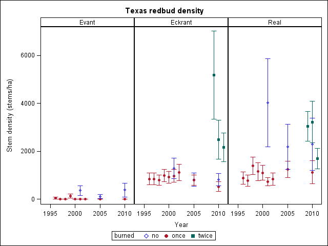
| Texas redbud | -- | -- | peak | decreasing | decreasing | variable | increasing |
| walnuts | -- | -- | -- | -- | -- | increasing | increasing |
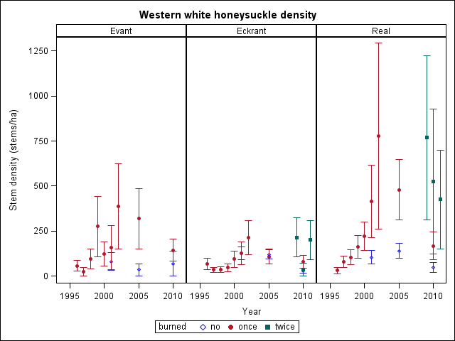
| western white honeysuckle | peak | variable | peak | decreasing | variable | peak | increasing |
| yucca | variable | increasing | peak | increasing | decreasing | increasing | increasing |
| Table 5. Density in postfire year 0 (mean ± standard error). H = Significantly higher than density in unburned transects (average of 2001, 2005, and 2010, not shown here). L = Significantly lower than density in unburned transects. * = Significantly higher after second fire than first fire (α = 0.05). -- = Species uncommon or not found on that soil type. |
|||||
1st fire |
1st fire |
2nd fire |
1st fire |
2nd fire |
|
| algerita | -- | 0 | 0 | -- | -- |
| Ashe juniper | 0 L | 0 L | 0 L | 0 L | 0 L |
| bastard oak | 229±172 | 24320±4520 | 62993±10342 H* | 7794±2469 | 30286±7682 H* |
| black prairie clover | -- | 0 | 0 | -- | -- |
| blackjack oak | 0 L | -- | -- | -- | -- |
| Buckley's oak | 967±629 | 2338±1018 | 5943±1589 | 10626±1186 | 29039±7215 H* |
| Carolina buckthorn | -- | -- | -- | 129±65 L | 119±70 L |
| cedar-elm | 637±285 | 329±236 | 0 | 0 L | 0 |
| Chinaberrytree | -- | -- | -- | 0 | 0 |
| chinkapin oak | -- | -- | -- | 47±47 | 0 |
| common hoptree | -- | 17±17 | 0 | 17±17 | 109±109 |
| dewberry | 33±23 L | 9±6 | 76±76 | 0 | 210±210 |
| eastern poison-ivy | 3624±1307 | 2415±514 | 48071±8380 H* | 3227±585 | 28161±4852 H* |
| Eve’s necklacepod | 0 | 0 | 0 | 0 | 0 |
| evergreen sumac | -- | 720±512 | 1157±442 | 330±180 | 2753±1364 H* |
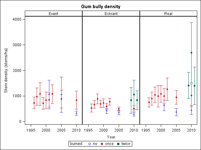
| gum bully | 729±231 | 529±159 | 829±503 | 748±181 | 1408±513 |
| Jersey tea | -- | -- | -- | 0 | 197±197 |
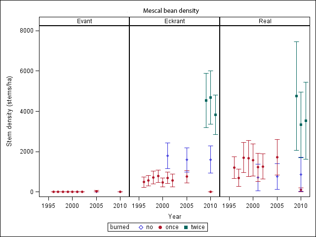
| mescal bean | -- | 480±261 | 4536±1348 H* | 1207±543 | 4753±2703 |
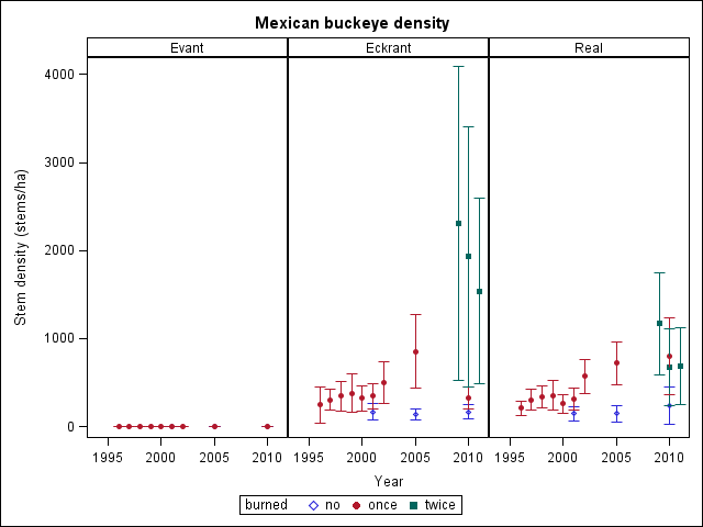
| Mexican buckeye | -- | 246±206 | 2307±1786 H* | 209±83 | 1169±584 * |
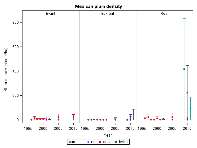
| Mexican plum | 0 | -- | -- | 10±10 | 416±416 |
| mustang grape | 5±5 L | -- | -- | 0 | 36±36 |
| netleaf hackberry | 267±137 | 494±231 | 900±662 | 70±42 | 5±5 |
| plums | -- | 0 | 0 | -- | -- |
| possumhaw | 1252±521 | 271±199 | 607±421 | 1029±457 | 4659±3425 |
| post oak | 3196±1442 | -- | -- | -- | -- |
| prairie sumac | 1390±299 H | 1014±153 | 20243±2679 H* | 1925±586 | 24057±6275 H* |
| pricklypear | 0 L | 0 L | 164±87 * | 0 L | 69±30 L |
| Rooseveltweed | 0 | 0 | 0 | 0 | 0 |
| roughleaf dogwood | -- | -- | -- | 0 | 57±57 |
| rusty blackhaw | 281±182 | 87±45 | 393±393 | 415±253 | 779±393 |
| saw greenbrier | 3429±1053 | 646±218 | 1543±530 | 740±148 | 2301±724 * |
| sevenleaf creeper | -- | 2±2 | 464±464 | 0 | 416±286 |
| skunkbush sumac | 24±19 | 1473±826 | 8400±2977 H* | 1453±795 | 7699±1854 H* |
| sorrelvine | -- | 0 | 0 | -- | -- |
| Spanish grape | 5±5 L | 0 L | 0 | 97±59 | 353±303 |
| stretchberry | 181±105 | 256±144 | 693±498 | 57±46 | 951±470 H* |
| sweet mountain grape | 76±71 | 370±146 | 579±306 | 581±163 | 1777±677 * |
| sycamoreleaf snowbell | -- | -- | -- | 67±67 | 914±914 |
| Texas ash | 814±505 L | 2246±590 L | 1350±724 L | 1990±465 | 9034±3447 * |
| Texas Hercules'-club | -- | 7±7 | 21±21 | 0 | 0 |
| Texas live oak | 1886±1448 | 3381±1281 | 836±836 | 199±123 | 343±337 |
| Texas mulberry | -- | -- | -- | 0 | 0 |
| Texas persimmon | -- | 114±65 | 50±50 | 152±87 | 603±322 |
| Texas redbud | -- | 842±243 | 5186±1838 H* | 877±250 | 3039±621 |
| walnuts | -- | -- | -- | 0 L | 0 |
| western white honeysuckle | 57±31 | 67±32 | 214±109 | 30±18 | 769±455 * |
| yucca | 0 | 0 | 1147±754 | 0 | 429±208 * |
 |
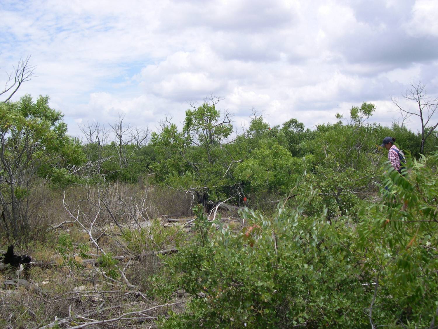
| Photo 1: Unburned bastard oak-Ashe juniper woodland on Eckrant soil. C. Reemts, 20 August 2010, The Nature Conservancy. |
 |
| Photo 2: Once-burned bastard oak shrubland on Eckrant in 2005, 9 years after the first fire. C. Reemts, July 2005, The Nature Conservancy. |
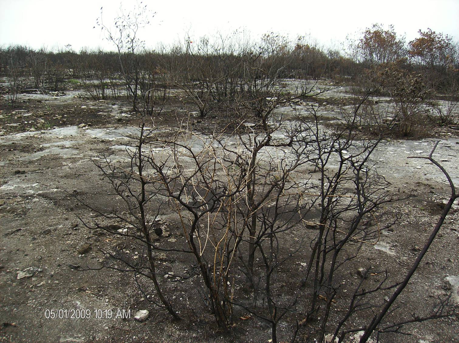 |
| Photo 3: The same site as Photo 2, less than 1 month following the second fire. C. Reemts, 1 May 2009, The Nature Conservancy. |
 |
| Photo 4: The same site as Photos 2 and 3, two years after the second fire. C. Reemts, July 2011, The Nature Conservancy. |
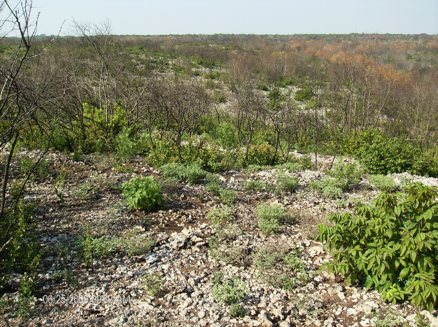 |
| Photo 5: View of twice-burned slope (Real soil) in June 2009 (2 months following the second fire). C. Reemts, 25 June 2009, The Nature Conservancy. |
 |
| Photo 6: View of twice-burned slope (Real soil) one year after the second fire. C. Reemts, 13 July 2010, The Nature Conservancy. |
The second wildfire did not further change species composition but did further alter vegetation structure. Initial density of understory stems was much higher after the second than after the first fire, perhaps because the reburned plants were smaller than before the first fire. Some species lose the ability to resprout after they reach a certain size, while sprouting ability decreases in many others. The somewhat lower fire intensity may also have contributed to the increased postfire sprouting. Because of the increased stem density, overstory basal area is recovering slightly more slowly from the second fire than from the first. Plants that invest energy into sprouting many stems have less energy to devote to growing large stems.
Historically, the vegetation in this area was likely a shifting mosaic of mature, rarely-burned woodlands and burned woodlands in varying stages of recovery from fire. Managing such a shifting mosaic is possible only in very large management units, because of the long recovery time for the mature woodlands. For this reason, wildfires should be suppressed in current golden-cheeked warbler habitat, especially in small patches where a single fire could destroy all available habitat. Overmature black-capped vireo habitat can be restored through prescribed fire or mechanical treatments. Where wildfire has created black-capped vireo habitat, these restoration practices can maintain it in a suitable successional stage.
RESOURCES:| Common name | Scientific name | Links to density graphs and FEIS reviews, if available |
| Cacti | ||
| pricklypear | Opuntia spp.* | density graph |
| Grasses | ||
| composite dropseed | Sporobolus compositus | FEIS review |
| dropseeds | Sporobolus spp. | |
| little bluestem | Schizachyrium scoparium | FEIS review |
| rosette grasses | Dichanthelium spp. | |
| Texas wintergrass | Nassella leucotricha | |
| threeawns | Aristida spp. | |
| sideoats grama | Bouteloua curtipendula | FEIS review |
| yellow bluestem | Bothriochloa ischaemum | Lianas |
| dewberry | Rubus spp.* | density graph |
| mustang grape | Vitis mustangensis | density graph |
| eastern poison-ivy | Toxicodendron radicans | density graph FEIS review |
| saw greenbrier | Smilax bona-nox | density graph FEIS review |
| sevenleaf creeper | Parthenocissus heptaphylla | density graph |
| sorrelvine | Cissus trifoliata | |
| Spanish grape | Vitis cinerea | density graph |
| sweet mountain grape | Vitis monticola | density graph |
| western white honeysuckle | Lonicera albiflora | density graph |
| Shrubs | ||
| algerita | Mahonia trifoliolata | density graph FEIS review |
| black prairie clover | Dalea frutescens | density graph |
| Carolina buckthorn | Frangula caroliniana | density graph |
| common hoptree | Ptelea trifoliata | density graph |
| evergreen sumac | Rhus virens | density graph |
| gum bully | Sideroxylon lanuginosum | density graph |
| Jersey tea | Ceanothus herbaceus | density graph |
| mescal bean | Sophora secundiflora | density graph FEIS review |
| Mexican buckeye | Ungnadia speciosa | density graph FEIS review |
| Mexican plum | Prunus mexicana | density graph |
| plums | Prunus spp.* | |
| possumhaw | Ilex decidua | density graph FEIS review |
| prairie sumac | Rhus lanceolata | density graph |
| Rooseveltweed | Baccharis neglecta | density graph |
| roughleaf dogwood | Cornus drummondii | density graph |
| rusty blackhaw | Viburnum rufidulum | density graph |
| skunkbush sumac | Rhus trilobata | density graph FEIS review |
| stretchberry | Forestiera pubescens | density graph |
| sycamoreleaf snowbell | Styrax platanifolius subsp. platanifolius | density graph |
| Texas Hercules'-club | Zanthoxylum hirsutum | |
| Texas mulberry | Morus microphylla | |
| Texas persimmon | Diospyros texana | density graph FEIS review |
| Texas redbud | Cercis canadensis var. texensis | density graph FEIS review |
| yucca | Yucca spp.* | density graph |
| Trees | ||
| Ashe juniper | Juniperus ashei | density graph FEIS review |
| bastard oak | Quercus sinuata var. breviloba | density graph |
| blackjack oak | Quercus marilandica | density graph FEIS review |
| Buckley's oak | Quercus buckleyi | density graph |
| cedar-elm | Ulmus crassifolia | density graph |
| Chinaberrytree | Melia azedarach | density graph FEIS review |
| chinkapin oak | Quercus muehlenbergii | FEIS review |
| Eve's necklacepod | Styphnolobium affine | density graph |
| netleaf hackberry | Celtis reticulata | density graph FEIS review |
| post oak | Quercus stellata | density graph FEIS review |
| Texas ash | Fraxinus texensis | density graph |
| Texas live oak | Quercus fusiformis | density graph |
| walnuts | Juglans spp.* | |
| *Opuntia spp.: Mostly O. engelmannii var. lindheimeri, but also includes O. engelmannii var.
linguiformis, O. macrorhiza, and O. phaeacantha. Grouped due to inconsistent identification of less common species. |
||
| Rubus spp.: Mostly R. trivialis, but also includes R. aboriginum. Grouped due to inconsistent identification of R. aboriginum. | ||
| Prunus spp.: Mostly P. munsoniana, but also includes P. umbellata. | ||
| Yucca spp.: Mostly Y. pallida, but also includes Y. arkansana. | ||
| Juglans spp.: Mostly J. major, but also includes J. nigra. | ||
1. Barrett, S.; Havlina, D.; Jones, J.; Hann, W.; Frame, C.; Hamilton, D.; Schon, K.; Demeo, T.; Hutter, L.; Menakis, J. 2010. Interagency Fire Regime Condition Class Guidebook. Version 3.0, [Online]. In: Interagency Fire Regime Condition Class (FRCC). U.S. Department of Agriculture, Forest Service; U.S. Department of the Interior; The Nature Conservancy (Producers). Available: http://www.frcc.gov/ [2013, May 13]. [85876]
2. LANDFIRE Rapid Assessment. 2005. Reference condition modeling manual (Version 2.1), [Online]. In: LANDFIRE. Cooperative Agreement 04-CA-11132543-189. Boulder, CO: The Nature Conservancy; U.S. Department of Agriculture, Forest Service; U.S. Department of the Interior (Producers). 72 p. Available: http://www.landfire.gov/downloadfile.php?file=RA_Modeling_Manual_v2_1.pdf [2007, May 24]. [66741]
3. LANDFIRE Rapid Assessment. 2007. Rapid assessment reference condition models, [Online]. In: LANDFIRE. U.S. Department of Agriculture, Forest Service, Rocky Mountain Research Station, Fire Sciences Lab; U.S. Geological Survey; The Nature Conservancy (Producers). Available: http://www.landfire.gov/models_EW.php [2008, April 18] [66533]
4. Reemts, Charlotte M.; Hansen, Laura L. 2008. Slow recolonization of burned oak-juniper woodlands by Ashe juniper (Juniperus ashei): ten years of succession after crown fire. Forest Ecology and Management. 255(3-4): 1057-1066. [69954]
5. U.S. Department of the Interior, National Park Service, Western Region. 1992. Western Region Fire Monitoring Handbook. San Francisco, CA: U.S. Department of the Inerior, National Park Service, Western Region. 89 p. [86310]