| FEIS Home Page |
 |
|
| © David Bleakly |
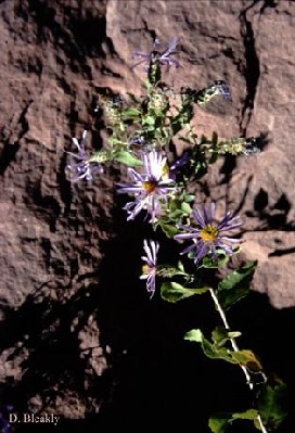
Horrid herrickia's distribution and is limited to southeastern Colorado and northeastern New Mexico but is fairly frequent within its range [6,11,13,18]. Plants Database provides a distributional map of horrid herrickia.
Horrid herrickia occurs on dry, south-facing slopes in high mountains and shaded, north-facing slopes at low elevations. It grows on sandy shales from upper montane coniferous forests down to the juniper (Juniperus spp.) savannas and is often associated with oak (Quercus spp.) scrub. Horrid herrickia ranges from 4,100 to 10,700 feet (1,250-3,250 m) in elevation [13].
Horrid herrickia does not appear to be palatable to wildlife or livestock [13].
Horrid herrickia is likely top-killed by fire. It is possible that it could regenerate after fire from of its underground root crown.
Further research is need on all aspects of horrid herrickia.| Fire regime information on vegetation communities in which horrid herrickia may occur. This information is taken from the LANDFIRE Rapid Assessment Vegetation Models [10], which were developed by local experts using available literature, local data, and/or expert opinion. This table summarizes fire regime characteristics for each plant community listed. The PDF file linked from each plant community name describes the model and synthesizes the knowledge available on vegetation composition, structure, and dynamics in that community. Cells are blank where information is not available in the Rapid Assessment Vegetation Model. | |||||
| Southwest | |||||
| Vegetation Community (Potential Natural Vegetation Group) | Fire severity* | Fire regime characteristics | |||
| Percent of fires | Mean interval (years) |
Minimum interval (years) |
Maximum interval (years) |
||
| Southwest Grassland | |||||
| Montane and subalpine grasslands with shrubs or trees | Replacement | 30% | 70 | 10 | 100 |
| Surface or low | 70% | 30 | |||
| Southwest Shrubland | |||||
| Gambel oak | Replacement | 75% | 50 | ||
| Mixed | 25% | 150 | |||
| Mountain-mahogany shrubland | Replacement | 73% | 75 | ||
| Mixed | 27% | 200 | |||
| Southwest Woodland | |||||
| Madrean oak-conifer woodland | Replacement | 16% | 65 | 25 | |
| Mixed | 8% | 140 | 5 | ||
| Surface or low | 76% | 14 | 1 | 20 | |
| Pinyon-juniper (mixed fire regime) | Replacement | 29% | 430 | ||
| Mixed | 65% | 192 | |||
| Surface or low | 6% | >1,000 | |||
| Pinyon-juniper (rare replacement fire regime) | Replacement | 76% | 526 | ||
| Mixed | 20% | >1,000 | |||
| Surface or low | 4% | >1,000 | |||
| Ponderosa pine/grassland (Southwest) | Replacement | 3% | 300 | ||
| Surface or low | 97% | 10 | |||
| Bristlecone-limber pine (Southwest) | Replacement | 67% | 500 | ||
| Surface or low | 33% | >1,000 | |||
| Southwest Forested | |||||
| Riparian forest with conifers | Replacement | 100% | 435 | 300 | 550 |
| Riparian deciduous woodland | Replacement | 50% | 110 | 15 | 200 |
| Mixed | 20% | 275 | 25 | ||
| Surface or low | 30% | 180 | 10 | ||
| Ponderosa pine-Gambel oak (southern Rockies and Southwest) | Replacement | 8% | 300 | ||
| Surface or low | 92% | 25 | 10 | 30 | |
| Ponderosa pine-Douglas-fir (southern Rockies) | Replacement | 15% | 460 | ||
| Mixed | 43% | 160 | |||
| Surface or low | 43% | 160 | |||
| Southwest mixed conifer (warm, dry with aspen) | Replacement | 7% | 300 | ||
| Mixed | 13% | 150 | 80 | 200 | |
| Surface or low | 80% | 25 | 2 | 70 | |
| Southwest mixed conifer (cool, moist with aspen) | Replacement | 29% | 200 | 80 | 200 |
| Mixed | 35% | 165 | 35 | ||
| Surface or low | 36% | 160 | 10 | ||
| Aspen with spruce-fir | Replacement | 38% | 75 | 40 | 90 |
| Mixed | 38% | 75 | 40 | ||
| Surface or low | 23% | 125 | 30 | 250 | |
| Stable aspen without conifers | Replacement | 81% | 150 | 50 | 300 |
| Surface or low | 19% | 650 | 600 | >1,000 | |
| Lodgepole pine (Central Rocky Mountains, infrequent fire) | Replacement | 82% | 300 | 250 | 500 |
| Surface or low | 18% | >1,000 | >1,000 | >1,000 | |
| Spruce-fir | Replacement | 96% | 210 | 150 | |
| Mixed | 4% | >1,000 | 35 | >1,000 | |
|
*Fire Severities— Replacement: Any fire that causes greater than 75% top removal of a vegetation-fuel type, resulting in general replacement of existing vegetation; may or may not cause a lethal effect on the plants. Mixed: Any fire burning more than 5% of an area that does not qualify as a replacement, surface, or low-severity fire; includes mosaic and other fires that are intermediate in effects. Surface or low: Any fire that causes less than 25% upper layer replacement and/or removal in a vegetation-fuel class but burns 5% or more of the area [5,9]. |
|||||
1. Allred, Kelly W. 1990. Elmer Ottis Wooton and the botanizing of New Mexico. Systematic Botany. 15(4): 700-719. [64731]
2. Bernard, Stephen R.; Brown, Kenneth F. 1977. Distribution of mammals, reptiles, and amphibians by BLM physiographic regions and A.W. Kuchler's associations for the eleven western states. Tech. Note 301. Denver, CO: U.S. Department of the Interior, Bureau of Land Management. 169 p. [434]
3. Eyre, F. H., ed. 1980. Forest cover types of the United States and Canada. Washington, DC: Society of American Foresters. 148 p. [905]
4. Garrison, George A.; Bjugstad, Ardell J.; Duncan, Don A.; Lewis, Mont E.; Smith, Dixie R. 1977. Vegetation and environmental features of forest and range ecosystems. Agric. Handb. 475. Washington, DC: U.S. Department of Agriculture, Forest Service. 68 p. [998]
5. Hann, Wendel; Havlina, Doug; Shlisky, Ayn; [and others]. 2008. Interagency fire regime condition class guidebook. Version 1.3, [Online]. In: Interagency fire regime condition class website. U.S. Department of Agriculture, Forest Service; U.S. Department of the Interior; The Nature Conservancy; Systems for Environmental Management (Producer). 119 p. Available: http://frames.nbii.gov/frcc/documents/FRCC_Guidebook_2008.07.10.pdf [2008, September 03]. [70966]
6. Harrington, H. D. 1964. Manual of the plants of Colorado. 2nd ed. Chicago, IL: The Swallow Press, Inc. 666 p. [6851]
7. Kartesz, John T. 1999. A synonymized checklist and atlas with biological attributes for the vascular flora of the United States, Canada, and Greenland. 1st ed. In: Kartesz, John T.; Meacham, Christopher A. Synthesis of the North American flora (Windows Version 1.0), [CD-ROM]. Chapel Hill, NC: North Carolina Botanical Garden (Producer). In cooperation with: The Nature Conservancy; U.S. Department of Agriculture, Natural Resources Conservation Service; U.S. Department of the Interior, Fish and Wildlife Service. [36715]
8. Kuchler, A. W. 1964. Manual to accompany the map of potential vegetation of the conterminous United States. Special Publication No. 36. New York: American Geographical Society. 77 p. [1384]
9. LANDFIRE Rapid Assessment. 2005. Reference condition modeling manual (Version 2.1), [Online]. In: LANDFIRE. Cooperative Agreement 04-CA-11132543-189. Boulder, CO: The Nature Conservancy; U.S. Department of Agriculture, Forest Service; U.S. Department of the Interior (Producers). 72 p. Available: https://www.landfire.gov /downloadfile.php?file=RA_Modeling_Manual_v2_1.pdf [2007, May 24]. [66741]
10. LANDFIRE Rapid Assessment. 2007. Rapid assessment reference condition models, [Online]. In: LANDFIRE. U.S. Department of Agriculture, Forest Service, Rocky Mountain Research Station, Fire Sciences Lab; U.S. Geological Survey; The Nature Conservancy (Producers). Available: https://www.landfire.gov /models_EW.php [2008, April 18] [66533]
11. Martin, William C.; Hutchins, Charles R. 1981. A flora of New Mexico. Volume 2. Germany: J. Cramer. 2589 p. [37176]
12. Nesom, G. L. 1995. Review of the taxonomy of Aster sensu lato (Asteraceae: Astereae), emphasizing the New World species. Phytologia. 77: 141-297. [54820]
13. New Mexico Rare Plant Technical Council 1999 [tbe]
14. Raunkiaer, C. 1934. The life forms of plants and statistical plant geography. Oxford: Clarendon Press. 632 p. [2843]
15. Shiflet, Thomas N., ed. 1994. Rangeland cover types of the United States. Denver, CO: Society for Range Management. 152 p. [23362]
16. Stickney, Peter F. 1989. Seral origin of species comprising secondary plant succession in Northern Rocky Mountain forests. FEIS workshop: Postfire regeneration. Unpublished draft on file at: U.S. Department of Agriculture, Forest Service, Rocky Mountain Research Station, Fire Sciences Laboratory, Missoula, MT. 10 p. [20090]
17. U.S. Department of Agriculture, Natural Resources Conservation Service. 2010. PLANTS Database, [Online]. Available: https://plants.usda.gov /. [34262]
18. Weber, William A.; Wittmann, Ronald C. 1996. Colorado flora: eastern slope. 2nd ed. Niwot, CO: University Press of Colorado. 524 p. [27572]