2023 Mushroom Gathering Guidelines
Mushroom picking in 2023 is for personal use only. No permit required.
There will be NO commercial permits sold in 2023.
2023 Personal Use Harvesting
Personal use harvesting - applies:
Pursuant to 36 CFR 261.50 (e), the following persons are exempt from this order: (0402-00-50):
-
Persons may personal harvest up to 5 gallons of morel mushrooms per person and possess up to 10 gallons per person per day.
-
The mushrooms are used for non-commercial purposes.
-
Mushrooms are not to be sold for profit.
If you need further information about area, road or trail closures, go to the Alerts and Notices page. Boise National Forest Alerts and Notices page.
Locations and Best Times to Pick
The best times for successful mushroom gathering are dependent upon the picking area. Mushrooms emerge in the spring when moisture, soil, aspect, snow levels and temperatures are just right. Generally the season starts in late May and extends through June.
Most often the best location for mushrooms is in areas that were burned or the soil was disturbed the previous year. Sometimes there are mushrooms found two-three years after the burn, although usually the first year is generally the optimal season. The spring snow pack helps determine the amount and timing of mushroom growth. Snow melt can greatly influence when, and for how long, mushrooms survive.
Please use caution, because of this year's above normal snow pack, roads at elevations above 5000 feet may remain impassible due to snow and debris through June! Also rivers and creeks are running very high and can be dangerous.
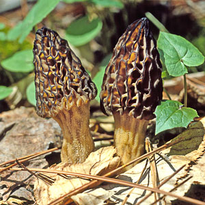
Know Your Mushrooms!
Each year interest grows in harvesting wild edibles from National Forests around the country. In many places, it's bracken ferns or pine nuts, but locally the primary interest lies in wild mushrooms. Proper identification and determination of whether a mushroom is edible is solely the responsibility of the picker.
Reference Maps of Wildfires
2021 Wildfire Maps
1980-2020 - Boise NF - History map of large Wildfires
2010-2020 - Boise NF - History map of large Wildfires
Boise NF had only one fire over 100 acres in 2021 - Deer Fire +- 865 acres - The Fire was lightning caused, ignited July 28, 2021, located 3 miles north of Arrowrock Dam along the #268 road within Mountain Home RD.
Salmon Challis NF - Boundary Fire - threatened to cross into the Boise NF late in the fire season near Fir Creek Camground within the Lowman RD. The fire was lightning caused on August 10, 2021, located 24 miles NW of Stanley and within the Middle Fork RD of the Frank Church River of No Return Wilderness.
2020 Wildfire Maps
1980-2020 - Boise NF - History map of large Wildfires
2010-2020 - Boise NF - History map of large Wildfires
Boise NF - Buck Fire +- 19, 474 acres - The Buck Fire was a lightning caused fire was ignited August 26, 2020, located 7 miles south of Yellow Pine within Cascade RD.
Boise NF - Grouse Fire +- 3999 acres - The Grouse Fire started September 6, 2020, the location was along the boundary of the Boise (Mountain Home RD) and Sawtooth National Forests about 6 miles northeast of Pine, Idaho, in the area of National Forest System (NFS) roads 166 and 166e.
Multiple agencies - Pumpkin Fire +- 438 acres - The lightning caused Pumpkin Fire, ignited August 6, 2020 and was a joint suppression between the Idaho Department of Lands, the USDA Boise National Forest, and the Bureau of Land Management. The fire was located ½ mile south of the Hawley Mountain Lookout, 7½ miles northeast of Horseshoe Bend and 8 miles southeast of Garden Valley.
Boise NF - Golden Fire +- 91 acres - The lightning caused Golden Fire located 3 miles southwest of Coulter Summit within the Idaho City RD started July 27.
Boise NF - Warm Fire +- 41 acres - The lightning caused Warm Fire located 3 miles south of Bull Trout Lake within the Lowman RD started July 27, 2020.
The Payette, Sawtooth and Salmon-Challis also had wildfires in 2020. Please contact the Forests for maps and information.
2019 Wildfire Maps
1980-2019 Boise NF - History map of large Wildfires
Boise NF - Canyon Fire +- 300 acres
Boise NF - Small Fires within Boise NF
2019 Wildfire Maps - Within Neighboring Forests
Payette NF - Nethker Fire +- 2,355 acres (off Burgdorf Road)
Salmon Challis NF -Shady Fire +- 4,109 acres,
Cove Creek Fire +- 5,013 acres, Vader Fire +- 400 acres,
Location map of Salmon NF Fires
2018 Wildfire Maps
1980-2018 History map of Boise NF large Fires
2018 Wapiti Fire General Vicinity Map
2018 Lodgepole Fire General Vicinity Map
2017 Wildfire Maps
1980-2017 History map of Boise NF large Fires
2017 Bearskin Fire General Vicinity Map
2016 Wildfire Maps
1900-2016 History map of Boise NF large fires
2016 Pioneer Fire General Vicinity Map
The Pioneer Fire was approximately 188,000 acres within the Idaho City RD and Lowman RD. The area includes the Rough (4,130 acres) and Buck (1,255 acres) Fires.
2016 - View Payette National Forest Commercial Mushroom Permit News Release
2016 - View Payette National Forest Mushroom Brochure
2015 Wildfire Maps
2015 History Map of Boise NF Large Fires
2015 Mushroom Maps Document - (from 2015 Fire Season)
2015 General Vicinity Map of Large Fires
2015 Boise National Forest
Cougar Fire- east of Cascade, ID
West Scriver Fire - north of Crouch, ID
Walker Fire - west of Idaho City, ID
2015 Wildfire Maps - Within Neighboring Forests
Payette National Forest: Commercial permits are available for Tepee Springs and Rapid Fire areas. 208-634-7000
Tepee Springs Fire- north of Mccall, ID
Rapid Fire - southeast of McCall, ID
Idaho Department of Lands:
West Scriver Fire - north of Crouch, ID
2014 Wildfire Large Maps
2014 History Map of Boise NF Large Fires
Whiskey Complex - Emmett RD - travel along Highway 17 toward the Garden Valley Workstation.
2013 Multiple Wildfire Large MAPS
2013 History Map of Boise NF Large Fires
Southwest Idaho Large Fire Vicinity Map
Big Game Units and the Fire Closure Areas
2013 Boise National Forest Wildfire Maps
Ridge Fire - Lowman RD - near Red Mountain
Frasier Fire - Emmett RD - along Highway 17, near the Crouch, ID - turnoff.
Pine Creek Fire - Idaho City RD - near Thorn Creek
Summit Fire -Idaho City RD - near Grimes Pass
Placer Fire - Idaho City RD - also near Thorn Creek (on large history map)
Little Queens Fire - Idaho City RD - near Atlanta, ID
North Fork Fire - Cascade RD, near Stolle Meadows (on large history map)
Boise NF Fire History Map has general locations
Kelly Fire -Mountain Home RD - near Featherville, ID
Elk Complex (more than one fire) - From Prairie to Pine, ID along South Fork Boise River.
Pony Complex (more than one fire) Along Blacks Creek Road to Anderson Ranch Reservoir.
2013 Wildfire Maps - Within Neighboring Forests
Southwest Idaho Large Fire Map has general locations.
Beaver Fire - Sawtooth National Forest - near Sun Valley and Ketchum, ID
McCann Fire - Sawtooth National Forest - near Fairfield, ID
Weiser Complex Fire Map - multiple fires