|
Bob Simonson, Program Leader |
|
San Dimas Technology
& Development Center
444 E Bonita Ave
San Dimas, CA 91773
(909) 599-1267
REY FARVE, Project Leader
|
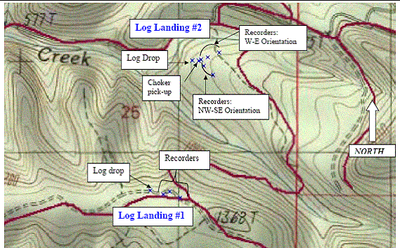
Methodology Sound data was not gathered at the service landing because: (1) the helicopter sound generated at this location is at its lowest noise level because the helicopter is not carrying a load, and (2) the helicopter visited the service landing only 3 to 4 times each day, reducing the opportunity of obtaining enough data for meaningful statistical analyses. During yarding activities, the helicopter continually travels to and from the hook points to the log landings. Either location provided an opportunity to collect measurements that could be statistically analyzed. The log landing—because of easier access and safer locations—provided better sound-sampling opportunities than the hook points. Consequently, most data sampling occurred at the log landings. Appendix 4 contains additional sound data recorded at hook points of another Oregon timber sale. At each log landing, three sound-measurement technicians set up their instruments in line from the landing. At the closest, the technicians were 100 to 200 feet from the log landing; and 500 to 900 feet away at the furthest (see figures 3a and 3b). The technicians remained at the same location throughout the data gathering session and took as many measurements as possible, time and weather permitting. |
|||||||||||||
We used a global positioning system (GPS) to fix the locations of the sound technicians and log landings. We recorded the log landing as a point where the helicopter released most of the logs during a data gathering session. The choker pickup point was recorded if it could be accomplished without interfering with logging operations. All GPS points were corrected by post-differential GPS. At the sound measuring point closest to the log landing, we stationed a technician with a Bruel & Kjaer 2204 precision sound level meter driving a high fidelity audio tape deck. Before and after each data gathering session, we placed a calibrated signal on the tape. When we returned to the laboratory, we played the tape back through a Bruel & Kjaer model 2305 graphic level recorder (a high-precision logarithmic pen recorder designed for use in acoustical measurements). After carefully calibrating the recorder with the recorded calibrated signal, we recorded each maximum sound-level value. The data point used in the report is the maximum field-recorded value. We instrumented the other two data-gathering locations with a Larson Davis model XLT or model 831 recording sound level meter. These meters have the capability of recording the maximum desired parameter in a given measurement period. The data gathering session began when technicians heard the helicopter approaching the log landing and stopped when technicians observed the helicopter departing the landing area. Also, the technician closest to the log landing sent a radio signal to the other technicians when he first perceived the approaching helicopter and again after the helicopter departed the log landing. However, each instrument captured the perceived maximum sound level from each turn independently; therefore, there is no time coordination between the data gathered at each of the three locations. Further—because of the inevitable instrumentation difficulties and human error—some turns did not have data from each of the three distances (stations). At both timber-sale sites, we took sound measurements at two different log landings (figures 3a and 3b). For each log landing location, we averaged all of the data points (i.e., the maximum sound level value) of a given distance together. The number of data points at each location varied from 6 to 24, with most locations having about 16. This ensured a valid statistical average for each location at each landing measurement session. The data set of all maximum sound-level values is shown in appendixes 2 and 3. | ||||||||||||||