
Challis-Yankee Fork Region
This area is accessed from State Route 75 and U. S. Highway 93 and includes beautiful stretches of the Upper Salmon River and portions of the East Fork of the Salmon River. The Challis-Yankee Fork Recreation Region is administered by the Challis-Yankee Fork office in Challis, Idaho.
General Information
Address: 311 N. US Highway 93 Challis , ID 83266
Hours of Operation: 8:00 am - 4:30 pm (Closed on federal holidays)
Office Phone: 208-879-4100
Office Email: sm.fs.middlefork@usda.gov
Mailing Address: 311 N. US Highway 93 Challis , ID 83226
Complexes
This area encompasses trails and trailheads in the Basin Creek, Basin Butte, and Valley Creek area that are on the Challis-Yankee Fork Ranger District. Joe's Gulch and Kelly creek area are also here.

This trailhead has hitching rails and dispersed campsites. No toilet or drinking water is available.
This area encompasses trails and trailheads in the Basin Creek, Basin Butte, and Valley Creek area that are on the Challis-Yankee Fork Ranger District. Joe's Gulch an
This area is a popular destination for a variety of recreation uses. Paasasikwana Naokwaide was formerly called Squaw Creek. A partnership with the State Park at the historic Bayhorse Townsite provides ATV trail riding. Camping and fishing at the campgrounds at Bayhorse and Little Bayhorse Lakes draws visitors during the summer months.
This area is a popular destination for a variety of recreation uses. Paasasikwana Naokwaide was formerly called Squaw Creek. A partnership with the State Park a
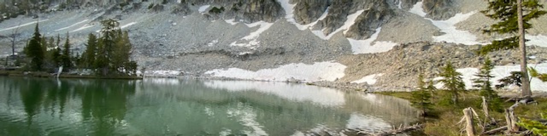
A beautiful high mountain lake is the setting for this out of the way campground. Plenty of fishing in lake and streams. Good hiking and ATV trail access.
Beautiful high mountain lake with plenty of fishing. Hiking trail connects to Bayhorse Lake. Three primitive campsites are equipped with picnic tables and fire rings.
This trailhead provides access to both the Yankee Fork and Bayhorse areas through the trail system. There is very little development; only mangers for stock and
A beautiful high mountain lake is the setting for this out of the way picnic area. Plenty of fishing in lake and streams. Good hiking and ATV trail access.
This area generally encompasses trails, trailheads, campgrounds and other recreation opportunities in the Cape Horn Country that are outside the Wilderness boundary. Campgrounds in this area include Lola, Beaver, Banner, Bench and Thatcher, just off Highway 21, plus Vader Rest Stop. In the winter, the Cape Horn Guard Station may be rented.
A nice campground along Highway 21 in the trees with a small creek running through. Campground has 5 campsites with picnic tables and fire rings with cooking grills.
Beautiful setting along Beaver Creek, this campground is close to access for the Frank Church River of No Return Wilderness.
A nice small campground in the trees along Bench Creek near Highway 21. Fishing in the stream and nearby Bull Trout Lake.
Lola Creek Campground sits adjacent to Marsh Creek. Marsh Creek Trailhead is a short distance away as is the trailhead to Lola Lakes.
This campground is just off Highway 21, and tucked back into the trees, overlooking beautiful Capehorn meadows.
Beaver Creek Trailhead provides access to Wilderness trails in the Cape Horn area. Trail #4021 South Fork of Fall Creek is accessed from this trailhead (this trail is
Trailhead for the Knapp-Loon Creek Trail #4036 in the Cape Horn area.
This trailhead provides access for the Marsh Creek Trail #4237, the Bear Valley-Marsh Creek Trail #4010, and the Middle Fork Trail #001.
Picnic area with incredible views of the Sawtooth Range and Valley Creek Meadows. Two picnic sites and an accessible vault toilet are onsite.
Cape Horn Winter Rental is located in Cape Horn Meadows approximately 16 miles northwest of Stanley, Idaho, situated in a stand of lodgepole pines at an elevation of 6,660