| Collection: | Southern Research Station Historical Documents and Images |
| Keywords: | runoff |
| Location: | East Nesbitt Creek, Irons Fork Experimental Forest, Arkansas |
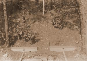
| Description: | Caption reads: "Hoover-Nesbitt runoff plots 9&10. View of surface runoff plots 9&10 taken from ladder tripod below plots. Plots are located on upper contour trail in East Nesbitt Creek. Covertype--open." |
| Date: | 10/23/1941 |
| Collection: | Southern Research Station Historical Documents and Images |
| Keywords: | runoff |
| Location: | East Nesbitt Creek, Irons Fork Experimental Forest, Arkansas |
| Description: | Caption reads: "Hoover-Nesbitt runoff plots 45&46. View of surface runoff plots 45&46 taken from ladder tripod below plots. Plots are located on lower contour trail in East Nesbitt Creek. Covertype--trees." |
| Date: | 11/18/1940 |
| Collection: | Southern Research Station Historical Documents and Images |
| Keywords: | runoff |
| Location: | East Nesbitt Creek, Irons Fork Experimental Forest, Arkansas |
| Description: | Caption reads: "Hoover-Nesbitt runoff plots 41&42. View of surface runoff plots 41&42 taken from ladder tripod below plots. Plots are located on lower contour trail in East Nesbitt Creek. Covertype--trees&reproduction." |
| Date: | 11/15/1940 |
| Collection: | Southern Research Station Historical Documents and Images |
| Keywords: | runoff |
| Location: | East Nesbitt Creek, Irons Fork Experimental Forest, Arkansas |
| Description: | Caption reads: "Hoover-Nesbitt runoff plots 47&48. View of surface runoff plots 47&48 taken from ladder tripod below plots. Plots are located on lower contour trail in East Nesbitt Creek. Covertype--reproduction (pine-hardwood)." |
| Date: | 10/28/1940 |
| Collection: | Southern Research Station Historical Documents and Images |
| Keywords: | runoff |
| Location: | East Nesbitt Creek, Irons Fork Experimental Forest, Arkansas |
| Description: | Caption reads: "Hoover-Nesbitt runoff plots 11&12. View of surface runoff plots 11&12 taken from ladder tripod below plots. Plots are located on upper contour trail in East Nesbitt Creek. Covertype--trees&reproduction." |
| Date: | 10/22/1940 |
| Collection: | Southern Research Station Historical Documents and Images |
| Keywords: | runoff |
| Location: | East Nesbitt Creek, Irons Fork Experimental Forest, Arkansas |
| Description: | Caption reads: "Hoover-Nesbitt runoff plots 13&14. View of surface runoff plots 13&14 taken from ladder tripod below plots. Plots are located on upper contour trail in East Nesbitt Creek. Covertype--reproduction (hardwood)." |
| Date: | 10/22/1940 |
| Collection: | Southern Research Station Historical Documents and Images |
| Keywords: | runoff |
| Location: | East Nesbitt Creek, Irons Fork Experimental Forest, Arkansas |
| Description: | Caption reads: "View of surface runoff plots 15&16 taken from ladder tripod below plots. Plots are located on upper contour trail in East Nesbitt Creek. Covertype--trees." |
| Date: | 10/22/1940 |
| Collection: | Southern Research Station Historical Documents and Images |
| Keywords: | runoff |
| Location: | East Nesbitt Creek, Irons Fork Experimental Forest, Arkansas |
| Description: | Caption reads: "Hoover-Nesbitt runoff plots 43&44. View of surface runoff plots 43&44 taken from ladder tripod below plots. Plots are located on lower contour trail in East Nesbitt Creek. Covertype--open." |
| Date: | 10/22/1940 |


