
 U.S. Department of Agriculture
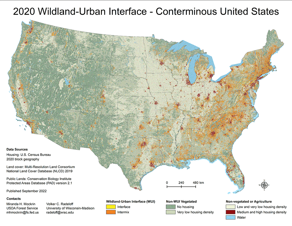 The 1990-2020 wildland-urban interface of the conterminous United States - geospatial data (4th Edition)
The Wildland-Urban Interface (WUI) is the area where houses meet or intermingle with undeveloped wildland vegetation. This makes the WUI a focal area for human-environment conflicts such as wildland fires, habitat fragmentation, invasive species, and biodiversity decline. Using geographic information systems (GIS), we integrated U.S. Census and USGS National Land Cover Data, to map the Federal Register definition of WUI (Federal Register 66:751, 2001) for the conterminous United States from 1990-2020. These data are useful within a GIS for mapping and analysis at national, state, and local levels.
 Data from monitoring inter-group encounters at the Alpine Lakes Wilderness in 1991
Many managers face the challenge of monitoring rates of visitor encounters in wilderness. This study, conducted in 1991 at Alpine Lakes Wilderness in Washington State: (1) provides estimates of encounter rates through use of several monitoring methods, (2) determines the relationship between the various measures of encounter rates, and (3) determines the relationship between various indirect predictors of encounter rates and actual encounter rates. In order to develop a better understanding of the relationship between these various monitoring methods, this study used exit surveys, trip diaries, wilderness ranger observations, trained observers, mechanical counters, trailhead count observations, and parking lot vehicle counts.
 Spatial wildfire occurrence data for the United States, 1992-2015 (6th Edition)
This data publication contains a spatial database of wildfires that occurred in the United States from 1992 to 2020. It includes 2.3 million geo-referenced wildfire records, representing a total of 180 million acres burned during the 29-year period. wildfire records were acquired from the reporting systems of federal, state, and local fire organizations. Core data elements are: discovery date, final fire size, and a point location at least as precise as a Public Land Survey System (PLSS) section (1-square mile grid). The data were transformed to conform, when possible, to the data standards of the National Wildfire Coordinating Group (NWCG), including an updated wildfire-cause standard (approved August 2020). Basic error-checking was performed and redundant records were identified and removed, to the degree possible.
 Grassland bird nesting ecology: video samples of behavior (2nd Edition)
Grassland birds construct nests on the ground that are generally well camouflaged by surrounding vegetation. Consequently, their nesting ecology has been more difficult to observe than the ecology of cavity- or shrub-nesting birds. Using video cameras to record behavior of adults and nestlings helps improve our understanding of nesting ecology. This, in turn, improves our management insights and facilitates placing the nesting ecology of grassland birds in the broader context of the nesting ecology of birds. Each of the 20 MP4 videos has a brief description in the included catalog. These fascinating videos document the authors’ insights on the nesting ecology of grassland birds in Wisconsin, USA, and Alberta, Canada.
 Wildfire Hazard Potential for the United States (270-m), version 2023 (4th Edition)
Federal wildfire managers often want to know, over large landscapes, where wildfires are likely to occur and how intense they may be. This wildfire hazard potential (WHP) map is a raster geospatial product that can help inform evaluations of wildfire risk or prioritization of fuels management needs across very large spatial scales (millions of acres). Our specific objective was to depict the relative potential for wildfire that would be difficult for suppression resources to contain. This 2023 version of WHP was created from updated national wildfire hazard datasets of annual burn probability and fire intensity generated with the large fire simulation system (FSim), as well as vegetation and wildland fuels data from LANDFIRE 2020. As such, the data presented here reflect landscape conditions as of the end of 2020. LANDFIRE 2020 vegetation and fuels data were also used directly in the WHP mapping process, along with updated point locations of fire occurrence ca. 1992-2020. We present the final WHP map in two forms: 1) continuous integer values, and 2) five WHP classes of very low, low, moderate, high, and very high.
 Incidental and long-distance bird observations in the Shoshone, Toiyabe, Toquima, and Monitor ranges, Nevada
These data document detections of birds in canyons throughout four mountain ranges in the central Great Basin (Lander, Nye, and Eureka counties, Nevada): the Shoshone Mountains, Toiyabe Range, Toquima Range, and Monitor Range. Data were collected during the 2002-2015 breeding seasons, inclusive, and in 2018. These data complement those in Fleishman 2019, which included detections of breeding birds during fixed-radius point counts within 100 meters of the observer. The new data allow more-complete documentation of the composition and distribution of the local / regional avifauna than is possible with fixed-radius point-count data alone. Data include species detected, date of detection, and, in most cases, method of detection and either coordinates or an approximate location.
Ever wonder how science knows what it knows? Mostly by thinking about observations made on the natural world, also known as data. The roots of our research are in the data we collect. Short-term sharing of research data is important for the transparency and reproducibility of the research results our scientists publish in research papers. Preserving these data for long-term use is important to being able to re-use the data for multiple purposes. The FS Research Data Archive offers a catalog of hundreds of research datasets funded by Forest Service Research and Development (FS R&D) or by the Joint Fire Science Program (JFSP). Of special interest, our collection includes long-term datasets from a number of Forest Service Experimental Forests, Ranges, and Watersheds (FS EFRs).
Data publications listed in the catalog are publicly available either from us or another scientific data repository (the publication description page will include a link to the dataset’s location if in a different repository). Each published dataset comes with a complete set of metadata (data documentation) and other information the scientist considered important to understanding and successfully using the data. Most data publications that we have released are downloadable; others have a database query interface to help you get that part of the large dataset which is of interest to you. Some data are also available through a map service. Check out the catalog and discover if there are data of interest to you!
We encourage you to use our data publications! We do ask that you acknowledge the work of our scientists by using the citation provided with each data publication. An example and more information are available in Terms of Use.
If you have questions, please contact the Archive team.