| Collection: | Fort Valley Experimental Forest historical photographs |
| Keywords: |
logging snow study |
| Location: | Apache NF; AZ; USA |
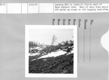
| Description: | Looking SSW in clearcut blocks east of Reno lookout road. East of main draw about 100 yrds up slope on old logging road. |
| Date: | 03/15/1967 |
| Collection: | Fort Valley Experimental Forest historical photographs |
| Keywords: |
logging snow forest stand |
| Location: | Apache NF; AZ; USA |
| Description: | Looking WSW in clearcut blocks east of Reno lookout road. East of main draw about 100 yards up slope on old logging road. |
| Date: | 03/15/1967 |
| Collection: | Fort Valley Experimental Forest historical photographs |
| Keywords: |
logging snow cleared plots study |
| Location: | Apache NF; AZ; USA |
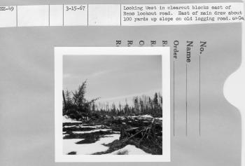
| Description: | Looking west in clearcut blocks east of Reno lookout road. East of main draw about 100 yards up slope on old logging road. |
| Date: | 03/15/1967 |
| Collection: | Fort Valley Experimental Forest historical photographs |
| Keywords: |
logging cleared plots |
| Location: | Apache NF; AZ; USA |
| Description: | Looking SSW in clearcut blocks east of Reno lookout road. East of main draw about 100 yards up slope on old logging road. |
| Date: | 03/15/1967 |
| Collection: | Fort Valley Experimental Forest historical photographs |
| Keywords: |
logging cleared plots |
| Location: | Apache NF; AZ; USA |
| Description: | Looking N in clearcut blocks east of Reno lookout road. East of main draw about 100 yards up slope on old logging road. |
| Date: | 03/15/1967 |
| Collection: | Fort Valley Experimental Forest historical photographs |
| Keywords: |
logging cleared plots study |
| Location: | Apache NF; AZ; USA |
| Description: | Looking E in clearcut blocks east of Reno lookout road. East of main draw about 100 yards up slope on old logging road. |
| Date: | 03/15/1967 |
| Collection: | Fort Valley Experimental Forest historical photographs |
| Keywords: |
snow cleared plots forest stand study |
| Location: | Apache NF; AZ; USA |
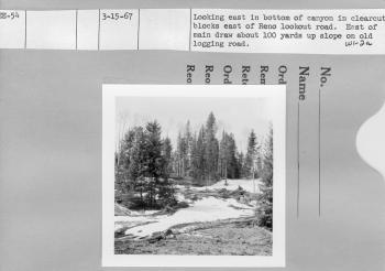
| Description: | Looking East in bottom of canyon in clearcut blocks east of Reno lookout road. East of main draw about 100 yards up slope on old logging road. |
| Date: | 03/15/1967 |
| Collection: | Sierra Ancha Historical Images |
| Keywords: |
snow forest stand study |
| Location: | Apache NF; AZ; USA |
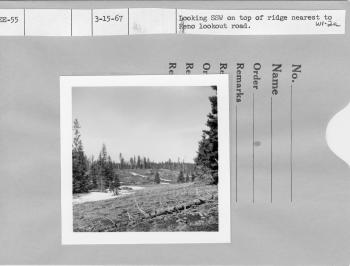
| Description: | Looking SSW on top of ridge nearest to Reno lookout rd. |
| Date: | 03/15/1967 |
| Collection: | Sierra Ancha Historical Images |
| Location: | Reno lookout rd.; NV |
| Description: | Looking east on top of ridge nearest to Reno lookout rd. |
| Date: | 03/15/1967 |
| Collection: | Fort Valley Experimental Forest historical photographs |
| Keywords: |
snow cleared plots study |
| Location: | Apache NF; AZ; USA |
| Description: | In front looking east- clearcut block south of Highway 666 1 mi. north of Reno lookout road from edge of clearcut. |
| Date: | 03/15/1967 |
| Collection: | Sierra Ancha Historical Images |
| Keywords: |
logging forest stand |
| Location: | Apache NF; AZ; USA |
| Description: | Looking east on top of ridge nearest to Reno lookout rd. |
| Date: | 03/15/1967 |
| Collection: | Fort Valley Experimental Forest historical photographs |
| Keywords: |
snow cleared plots study |
| Location: | Apache NF; AZ; USA |
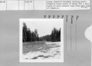
| Description: | Along clearcut boundary looking south. Clearcut block south of highway 666 1 mile north of Reno lookout road from east edge of clearcut. |
| Date: | 03/15/1967 |
| Collection: | Fort Valley Experimental Forest historical photographs |
| Keywords: |
snow cleared plots study |
| Location: | Apache NF; AZ; USA |
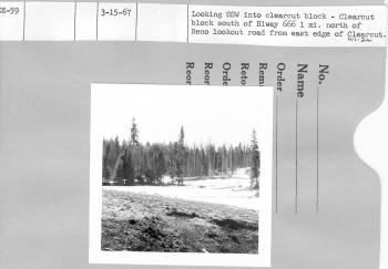
| Description: | Looking SSW into clearcut block south of highway 666 1 mi. north of Reno lookout road from east edge of clearcut. |
| Date: | 03/15/1967 |
| Collection: | Fort Valley Experimental Forest historical photographs |
| Keywords: |
snow cleared plots study |
| Location: | Apache NF; AZ; USA |
| Description: | Looking east- clearcut block south of highway 666 1 mi. north of Reno lookout road from east edge of clearcut. |
| Date: | 03/15/1967 |
| Collection: | Fort Valley Experimental Forest historical photographs |
| Keywords: |
logging snow cleared plots study |
| Location: | Apache NF; AZ; USA |
| Description: | Looking west- clearcut block south of highway 666 1 mi. north of Reno lookout road from east edge of clearcut. |
| Date: | 03/15/1967 |
| Collection: | Fort Valley Experimental Forest historical photographs |
| Keywords: |
snow forest stand |
| Location: | Hannagan Meadow; AZ; USA |
| Description: | North of Hannagan Meadow lodge looking SSW through Hannagan Meadow. |
| Date: | 03/15/1967 |
| Collection: | Sierra Ancha Historical Images |
| Keywords: |
forest stand study |
| Location: | Apache NF; AZ; USA |
| Description: | Repeat of EE-47 only at a later date. |
| Date: | 03/15/1967 |
| Collection: | Sierra Ancha Historical Images |
| Keywords: |
forest stand study |
| Location: | Apache NF; AZ; USA |
| Description: | Repeat of EE-48 only at a later date |
| Date: | 03/15/1967 |
| Collection: | Sierra Ancha Historical Images |
| Keywords: |
snow forest stand study |
| Location: | Apache NF; AZ; USA |
| Description: | Repeat of EE-49 only at a later date |
| Date: | 03/15/1967 |
| Collection: | Sierra Ancha Historical Images |
| Keywords: |
forest stand study |
| Location: | Apache NF; AZ; USA |
| Description: | Repeat of EE-50 only at a later date. |
| Date: | 03/15/1967 |

