| Collection: | Southern Research Station Historical Documents and Images |
| Keywords: |
impoundment dam |
| Location: | Irons Fork Experimental Forest, Arkansas |
| Description: | Caption reads: "Impounding dams. No. 3 East Lateral, Rock Creek." |
| Date: | 12/13/1939 |
| Collection: | Southern Research Station Historical Documents and Images |
| Keywords: |
ditch water diverter |
| Location: | Irons Fork Experimental Forest, Arkansas |
| Description: | Caption reads: "Contour ditch to serve as a diversion-spreader of run-off." |
| Date: | 12/13/1939 |
| Collection: | Southern Research Station Historical Documents and Images |
| Keywords: | runoff |
| Location: | East Hoover Creek, Irons Fork Experimental Forest, Arkansas |
| Description: | Caption reads: "Plots 63 and 64 of Hoover-Nesbitt surface runoff study showing collection troughs and 23-gallon collection cans." |
| Date: | 12/10/1939 |
| Collection: | Southern Research Station Historical Documents and Images |
| Keywords: |
selective cut watershed |
| Location: | Jones Creek drainage, Irons Fork Experimental Forest, Arkansas |
| Description: | Caption reads: "#7, Selective Watershed, Jones Creek. General view into watershed #7 before cutting. Camera faced N.E. Station on S.E. ridge of watershed. Camera Sta. #13." |
| Date: | 4/28/1939 |
| Collection: | Southern Research Station Historical Documents and Images |
| Keywords: | poletimber |
| Organisms: | shortleaf pine |
| Location: | Jones Creek drainage, Irons Fork Experimental Forest, Arkansas |
| Description: | Caption reads: "#7 Watershed, Jones Creek. General view of pole-sized stand on south slope, #7 watershed. These trees would all be taken were the watershed to be clear cut. Camera on ridge looking west. Camera Sta. #14." |
| Date: | 4/28/1939 |
| Collection: | Southern Research Station Historical Documents and Images |
| Keywords: |
selective cut watershed |
| Location: | Jones Creek drainage, Irons Fork Experimental Forest, Arkansas |
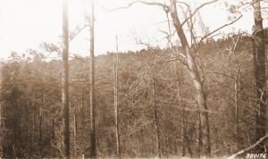
| Description: | Caption reads: "Ridge between #6 and #7 watersheds, Jones Creek. General view, #1 and #2 watersheds. Notice sharp line of demarkation [sic]: #1 selectively cut; #2 clear cut." |
| Date: | 4/28/1939 |
| Collection: | Southern Research Station Historical Documents and Images |
| Keywords: |
selective cut watershed |
| Location: | Jones Creek drainage, Irons Fork Experimental Forest, Arkansas |
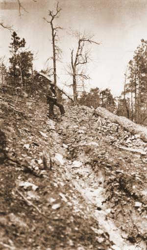
| Description: | Caption reads: "Ridge between #6 and #7 watersheds, Jones Creek. General view of #3 and #4 watersheds. Line of demarkation [sic] between clear-cut watershed #4 and selectively cut watershed #3." [watersheds not yet logged?] |
| Date: | 4/28/1939 |
| Collection: | Southern Research Station Historical Documents and Images |
| Keywords: |
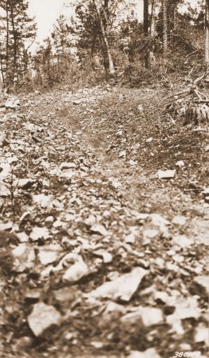
skid trail erosion |
| Location: | Jones Creek drainage, Irons Fork Experimental Forest, Arkansas |
| Description: | Caption reads: "#2 Watershed, Jones Creek. Logging road. Logging road in the process of construction. No erosion of washes here as yet. Camera Sta. #15." |
| Date: | 4/28/1939 |
| Collection: | Southern Research Station Historical Documents and Images |
| Keywords: | watershed |
| Location: | Jones Creek drainage, Irons Fork Experimental Forest, Arkansas |
| Description: | Caption reads: "#2 Watershed, Jones Creek. View at upper end of clear-cut watershed. Shows natural stand before logging. Camera Sta. #16. Camera sta. 30 yds. S.W. from upper log yard. Camera faced S.W." |
| Date: | 4/28/1939 |
| Collection: | Southern Research Station Historical Documents and Images |
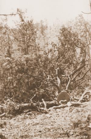
| Keywords: | clearcut |
| Location: | Jones Creek drainage, Irons Fork Experimental Forest, Arkansas |
| Description: | Caption reads: "#2 Watershed, upper section logging road, Jones Creek. Top intact following logging on clear-cut area. Taken immediately after logging. Needles green and persistent. Extra large top. Average diameter at cut 25 inches. Camera Sta. #17." |
| Date: | 4/28/1939 |
| Collection: | Southern Research Station Historical Documents and Images |
| Keywords: |
log deck selective cut |
| Location: | Jones Creek drainage, Irons Fork Experimental Forest, Arkansas |
| Description: | Caption reads: "#3 Watershed, Jones Creek. Disturbances of cover at log yard in selectively-cut watershed. Note trampled reproduction, washing of deeply rutted skid trail in background, general erosion and lack of vegetation in yard. Shot taken immediately after logging. Camera faced N.W. Camera Sta. #18 at log yard on log road." |
| Date: | 4/28/1939 |
| Collection: | Southern Research Station Historical Documents and Images |
| Keywords: |
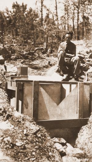
logging road weir |
| Location: | Jones Creek drainage, Irons Fork Experimental Forest, Arkansas |
| Description: | Caption reads: "#4 Watershed, Jones Creek. Logging road run-off plot with 90o v-notch weir and recorder. Natural plot encompassing approximately 1-acre." |
| Date: | 4/28/1939 |
| Collection: | Southern Research Station Historical Documents and Images |
| Keywords: |
skid trail erosion weir |
| Location: | Jones Creek drainage, Irons Fork Experimental Forest, Arkansas |
| Description: | Caption reads: "#4 Watershed, Jones Creek. Skid trail run-off plot. 90o v-notch weir with Friez portable recorder, plot approximately 1/5-acre." |
| Date: | 4/28/1939 |
| Collection: | Southern Research Station Historical Documents and Images |
| Keywords: |
log deck clearcut |
| Location: | Jones Creek drainage, Irons Fork Experimental Forest, Arkansas |
| Description: | Caption reads: "#4 Watershed, Jones Creek. Log yard, clear-cut watershed 10 days after logging. Note disturbance of ground cover. Yard completely barren of vegetation. Camera Sta. #19." |
| Date: | 4/28/1939 |
| Collection: | Southern Research Station Historical Documents and Images |
| Keywords: | clearcut |
| Location: | Jones Creek drainage, Irons Fork Experimental Forest, Arkansas |
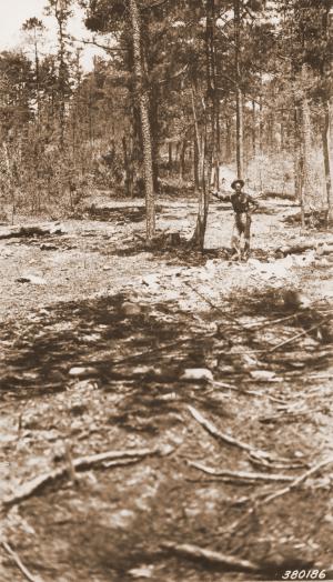
| Description: | Caption reads: "#6 Watershed, Jones Creek. General view in clear-cut watershed #6 before logging. Note good ground cover: (a) trees, (b) brush, (c) herbs and grass, (d) litter. Camera Sta. #20." |
| Date: | 4/28/1939 |
| Collection: | Southern Research Station Historical Documents and Images |
| Keywords: |
skid trail erosion |
| Location: | Jones Creek drainage, Irons Fork Experimental Forest, Arkansas |
| Description: | Caption reads: "#4 Watershed, Jones Creek. Skid trail one month after logging. Taken to show natural water course formed by skid trails. See FS-380170". |
| Date: | 4/11/1939 |
| Collection: | Southern Research Station Historical Documents and Images |
| Keywords: |
skid trail erosion |
| Location: | Jones Creek drainage, Irons Fork Experimental Forest, Arkansas |
| Description: | Caption reads: "#4 Watershed, Jones Creek. Skid trail in clearcut watershed. Slope 45%. Taken one month after logging, little erosion as yet. Camera Sta. #6, near logging road plot." |
| Date: | 4/11/1939 |
| Collection: | Southern Research Station Historical Documents and Images |
| Keywords: | clearcut |
| Location: | Jones Creek drainage, Irons Fork Experimental Forest, Arkansas |
| Description: | Caption reads: "Divide between #4 and #5 Watersheds, Jones Creek. General view of clear-cut watershed #4. Looking west. Camera Sta. #7." |
| Date: | 4/11/1939 |
| Collection: | Southern Research Station Historical Documents and Images |
| Keywords: | watershed |
| Location: | Jones Creek drainage, Irons Fork Experimental Forest, Arkansas |
| Description: | Caption reads: "#6 Watershed, Jones Creek. Before cutting. General view into watershed to be clear-cut. Camera faced east." |
| Date: | 4/11/1939 |
| Collection: | Southern Research Station Historical Documents and Images |
| Keywords: | watershed |
| Location: | Jones Creek drainage, Irons Fork Experimental Forest, Arkansas |
| Description: | Caption reads: "#6 Watershed, Jones Creek. General view north into #6 watershed before clear-cutting. Camera on ridge between #6 and #7, facing north." |
| Date: | 4/11/1939 |
| Collection: | Southern Research Station Historical Documents and Images |
| Keywords: | watershed |
| Organisms: | oak |
| Location: | Jones Creek drainage, Irons Fork Experimental Forest, Arkansas |
| Description: | Caption reads: "#6 Watershed in foreground, before cutting, Jones Creek. General view into watershed taken from oak tree on divide between #6 and #7. Camera faced N.W." |
| Date: | 4/11/1939 |
| Collection: | Southern Research Station Historical Documents and Images |
| Keywords: | watershed |
| Organisms: | oak |
| Location: | Jones Creek drainage, Irons Fork Experimental Forest, Arkansas |
| Description: | Caption reads: "#6 Watershed, before cutting, Jones Creek. General view into watershed taken from oak tree on divide between #6 and #7. Camera faced N.E." |
| Date: | 4/11/1939 |
| Collection: | Southern Research Station Historical Documents and Images |
| Keywords: |
skid trail erosion |
| Location: | Jones Creek drainage, Irons Fork Experimental Forest, Arkansas |
| Description: | Caption reads: "#4 Watershed, Jones Creek. Skid trail in watershed. Shows washing after 2-in. rain. Picture taken 2 days after rain. Camera Sta. #1." |
| Date: | 4/7/1939 |
| Collection: | Southern Research Station Historical Documents and Images |
| Keywords: |
skid trail erosion |
| Location: | Jones Creek drainage, Irons Fork Experimental Forest, Arkansas |
| Description: | Caption reads: "#4 Watershed, Jones Creek. Skid trail (area). Camera Sta. #2." |
| Date: | 4/7/1939 |
| Collection: | Southern Research Station Historical Documents and Images |
| Keywords: |
skid trail erosion |
| Location: | Jones Creek drainage, Irons Fork Experimental Forest, Arkansas |
| Description: | Caption reads: "#4 Watershed, Jones Creek. Logging road: shows erosion and severe washing following 2-inch rain of April 5, 1939. Camera Sta. #3." |
| Date: | 4/7/1939 |
| Collection: | Southern Research Station Historical Documents and Images |
| Keywords: | logging road |
| Location: | Irons Fork Experimental Forest, Arkansas |
| Description: | Caption reads: "Logging road plot, Jones Creek." |
| Date: | circa 1939 |
| Collection: | Southern Research Station Historical Documents and Images |
| Keywords: | logging |
| Location: | Irons Fork Experimental Forest, Arkansas |
| Description: | Caption reads: "Logging unit #6, Jones Creek. Showing slash conditions." |
| Date: | circa 1939 |
| Collection: | Southern Research Station Historical Documents and Images |
| Keywords: |
logging selective cut |
| Location: | Jones Creek drainage, Irons Fork Experimental Forest, Arkansas |
| Description: | Caption reads: "Picture taking from logging unit #6, Jones Creek. Looking west across creek to selectively cut unit #3 on left and clear cut unit #4 on right." |
| Date: | circa 1939 |
| Collection: | Southern Research Station Historical Documents and Images |
| Keywords: |
dam storm flow |
| Location: | Irons Fork Experimental Forest, Arkansas |
| Description: | Man building part of earthen dam to help hold stormflow water as a part of a research study on the Irons Fork Experimental Forest in Arkansas. |
| Date: | circa 1939 |
| Collection: | Southern Research Station Historical Documents and Images |
| Keywords: | dam |
| Location: | Irons Fork Experimental Forest, Arkansas |
| Description: | A man using a USFS bulldozer to move earth and stone, probably to build an earthen dam and holding pond on the Irons Fork Experimental Forest on the Ouachita National Forest in western Arkansas. |
| Date: | circa 1939 |




![Caption reads: "Ridge between #6 and #7 watersheds, Jones Creek. General view, #1 and #2 watersheds. Notice sharp line of demarkation [sic]: #1 selectively cut; #2 clear cut." Caption reads: "Ridge between #6 and #7 watersheds, Jones Creek. General view, #1 and #2 watersheds. Notice sharp line of demarkation [sic]: #1 selectively cut; #2 clear cut."](/rds/imagedb/images/_thm/28783.jpg)
![Caption reads: "Ridge between #6 and #7 watersheds, Jones Creek. General view of #3 and #4 watersheds. Line of demarkation [sic] between clear-cut watershed #4 and selectively cut watershed #3." [watersheds not yet logged?] Caption reads: "Ridge between #6 and #7 watersheds, Jones Creek. General view of #3 and #4 watersheds. Line of demarkation [sic] between clear-cut watershed #4 and selectively cut watershed #3." [watersheds not yet logged?]](/rds/imagedb/images/_thm/28784.jpg)
