| |
| Search all USDA |
|
Demonstration of Satellite/GPS Telemetry for Monitoring Fine-Scale Movements of Lesser Prairie-Chickens
Rey Farve, Project Leader Wildlife Radio-tracking TelemetryThe majority of the information in this section was obtained from Mech and Barber (2002), unless otherwise cited. Wildlife radio-tracking involves monitoring the radio signals sent from an animal-attached device to track the animal's movements. Telemetry is the process of transmitting the information through the atmosphere. Several distinct types of radio tracking are currently in use for tracking wildlife movements: (1) VHF (very high frequency) radio-tracking; (2) GPS tracking; (3) satellite tracking using the Argos system; and (4) a combination of the advantages of GPS and the Argos satellites into a GPS/satellite telemetry method. VHF tracking telemetry This is the traditional (conventional) telemetry method that has been in use since the mid-1960s. This method typically requires a user to acquire the VHF transmissions from a VHF transmitter (usually in a collar attached to the animal) via a hand-held antenna (figure 3). The location of the transmitter is usually determined by acquiring the transmissions from three (or more) different locations to triangulate the location of the device.
GPS tracking telemetry GPS technology involves a GPS receiver that accepts signals from several of the 24-plus GPS satellites that orbit the earth (figure 4). GPS satellites transmit lowpower radio signals that are picked up by a GPS receiver on earth. A receiver that picks up signals from three satellites can locate itself in two dimensions (latitude and longitude); signals from four satellites allow the receiver to locate itself in three dimensions.
GPS tracking telemetry typically involves attaching a GPS receiver (collar) to an animal to record (track) the animal's location over time. The GPS collar/receiver logs (stores) the location (and time) data on the device until it is retrieved either by: (1) recapturing the animal to extract GPS data stored on the collar, (2) remotely (i.e., wirelessly) downloading the GPS data stored on the collar to a separate, portable (usually handheld) receiver1; or (3) remotely relaying the GPS data to the Argos Satellite system. Method 3 is generally considered GPS/ satellite telemetry, which is discussed in section II.D. For a detailed discussion on the state-of-the-technology of GPS telemetry see Tomkiewicz et al. (2010). Satellite tracking telemetry This method has been available since the mid-1980s. Most current satellite telemetry uses the two polar-orbiting Argos satellites to receive ultra-high frequency signals from platform transmitter terminals (PTTs). The Argos satellite system (figure 5) is operated under an agreement between the French Government (French Space Agency) and the United States (NOAA and NASA) exclusively for the collection and distribution of environmental and natural resource data (Argos 2008). Most (about 80 percent) of the transmitters are on drifting or moored buoys, fixed land locations, or on ships and transmit meteorological and/or oceanographic data. With the miniaturization of PTTs in the mid-1990s, more PTTs are being attached to animals to track their movements. (For a more detailed discussion on the history of satellite telemetry see Fancy et al. 1988 and Seegar et al. 1996.)
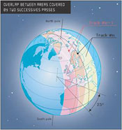
Since the two Argos satellites have a mostly polar orbit, they operate best for locations on earth greater than 60 degrees in latitude (i.e., areas not along the equator) (figure 6). For these areas (greater than 60 degrees), the satellites receive signals from PTTs during a 10–12 minute window as it passes over sites about 28 times per day. Areas around the equator (i.e., 0 to 20 degrees latitude) typically only get the two overlapping satellites about six passes per day. A network of ground and atmospheric communication links transfer the satellite data to processing centers in Toulouse, France, and Landover, Maryland, which distribute results to users worldwide (figure 7).
An animal-borne PTT location is determined by calculations that rely on the Doppler Effect; that is, the perceived change in frequency that results from the movement of a transmitter and receiver. For a detailed discussion of the polar orbit of satellites and how animal locations are determined using the Doppler Effect, see Fancy et al. 1988:10 and Harris et al. 1990:3. With satellite telemetry, the user can obtain locations of the animalborne PTT to within 100 meters (m) to 4 kilometers (km) (330 feet to 2.5 miles). Most readings obtained by the satellite are in the middle of this range. Obviously, technology that has an error range that broad is best used only for far-ranging species. GPS/Satellite telemetry GPS/satellite telemetry combines the technology of both the GPS receiver and satellite transmitter in one device to collect data on animals with a limited range. An animal that carries a GPS/satellite device stores its GPS location data (over time) on the device; this data is then transmitted every few days to the Argos satellite, where it can distribute the data worldwide (figure 7). This technology allows a user to collect fine-scale movement data of animals with limited ranges and have this data transmitted to any location.
1Space Data® can provide a communication platform that is created by a receiver attached to a weather balloon (called a high-altitude SkySite® Network) that could be used to retrieve GPS data and transmit it to users. Also Microwave Telemetry, Inc. has recently developed (and beta tested) transmitters that utilized the GSM (Global System for Mobile Communications) network. This allows the GSM/GPS transmitter to send the GPS data to cell towers and then to Microwave Telemetry's server for distribution to customers via e-mail attachments. |
|