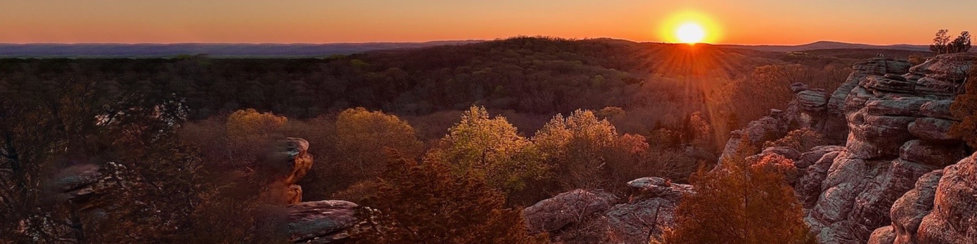
Special Places

  • Trail of Tears

    A placeholder image

    Looking for ways to explore history with kids this summer? Consider visiting the Trail of Tears National Historic Trail, just south of Jonesboro.

  • Take a Drive

    A placeholder image

    In a state known for rich farmland and big cities, the outstanding scenery of southern Illinois is a refreshing surprise. Forested Shawnee hills and rocky bluffs give way to gently rolling farmland, charming small towns, unique state parks and local antique and winery venues. Experience this diverse landscape and its people on the Ohio River National Scenic Byway and Great River Road.

  • Wilderness Areas

    A placeholder image

    Looking for solitude? Check out our seven wilderness areas, which were designated through the Illinois Wilderness Act of 1990. Wilderness areas are some of the largest contiguous forested lands within the Shawnee, and together they make up about 10 percent of the national forest. Visit our wilderness page for detailed information on special restrictions.

  • Historic Sites

    A placeholder image

    Travel along the Trail of Tears National Historic Trail, or discover forest sites used in the Underground Railroad. Some Shawnee National Forest sites are interpreted through signage, such as Illinois Iron Furnace (left) and Millstone Bluff Archeological Site. Help protect these archeological sites during your visit.

Highlighted Areas

Pomona Natural Bridge Trail

This short loop-trail (0.3 mile) winds through a mature oak-hickory and beech forest as it descends an overlook reveals a view of the arch or "bridge" made of sandstone for which it is named.  The stone arch or natural bridge as they usually called spans 90 feet across and is the result of millions of years of erosion. The trail leads across the top of the natural bridge, before looping back to the parking lot. It's a short trail with some inclines and has a bench for resting to enjoy the scenery along the path. The trail surface begins as wood chips or pebbles, but turns to natural dirt and rocky surface that can be slippery when wet. Wear sturdy, non-slip shoes and be extra cautious if you decide to walk across the natural bridge.

Pomona Natural Bridge Brochure and Map


Garden of the Gods Recreation Area

One of the most photographed locations in the state, Garden of the Gods' scenic beauty is extraordinary. In the recreation area you can hike, camp, nature watch or picnic.

The Observation Trail features unique sandstone rock formations and panoramic views of the surrounding Garden of the God Wilderness. Interpretive signs explain the geological history. The 1/4-mile trail is made of natural sandstone and takes about an hour to walk. It contains short, steep grades and steps; benches are located along the trail and as a whole the trail is not tiring. Caution should be used due to the high cliffs in the area.  

Garden of the Gods Brochure and Map 


Bell Smith Springs Recreation Area

Bell Smith Springs is one of the most beautiful recreation areas the Shawnee National Forest has to offer. It contains a series of clear, rocky streams and scenic canyons bordered by high sandstone cliffs and an abundance of vegetation unique to Illinois. The trail system consists of eight miles of interconnected trails featuring strange and wonderful rock formations, such as Devil's Backbone, Boulder Falls and a natural rock bridge. Hiking this system of trails is a favorite activity because of the rock features, scenic overlooks, hidden springs and lush flora and fauna. 
 

River to River Trail


Spanning from the Ohio River to the Mississippi River, this 160-mile trail passes through some of the most scenic areas of southern Illinois, including upland forests, wetlands, grasslands and bluffs. The trail leads through some of the most remote areas of the Shawnee as it passes through five of the seven nationally designated wilderness’, designated natural areas and several state parks. Abundant with wildlife you may see bald eagle, red-tailed hawk, bobcat, armadillo, red fox and is home to some 250 bird species.  

Most of the trail is on public lands (national forest or state parks), however some segments are along roads and across private land (where allowed). Enjoy tranquil locations such as bluffs overlooking Cedar Lake, painted sunset sky at Garden of the Gods, or migrating waterfowl resting in the floodplains of the Mississippi River.

Download Geo-referenced River to River Maps to use them on your tablet or smartphone for GPS navigation along the trail.


Lusk Creek Canoe/Kayak Access

Float one of the most scenic creeks in southern Illinois. Lusk Creek Canoe/Kayak access is located just minutes from Eddyville, IL and offers easy access for recreating on beautiful Lusk Creek. The site features a walk-down launch path, spaceous parking lot and information board with detailed map.

Due to its ecological significance the Shawnee National Forest designated Lusk Creek a Zoological Area within the boundaries of Lusk Creek Wilderness. Lusk Creek Wilderness lies about 4 miles north of this Lusk Creek access point. Special restrictions apply within the Wilderness and Zoological Area, see the restrictions section below.