

Confronting the Wildfire Crisis
Wildfire Crisis Strategy
The strategy, called “Confronting the Wildfire Crisis: A Strategy for Protecting Communities and Improving Resilience in America’s Forests,” combines a historic investment of congressional funding with years of scientific research and planning into a national effort that will dramatically increase the scale and pace of forest health treatments over the next decade. Through the strategy, the agency will work with states, Tribes and other partners to addresses wildfire risks to critical infrastructure, protect communities, and make forests more resilient. There are 21 total landscapes that comprise the strategy. The Colorado Front Range is one of those landscapes.
Colorado Front Range Landscape
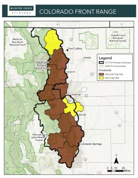
The Front Range encompasses the eastern side of the Rocky Mountains in Colorado. It has seen increasingly devastating wildfires, with 4 of the 5 largest fires in Colorado history having occurred since 2018, and the 3 largest in 2020 alone. This devastation reaches around 5 million residents and millions of visitors. The Colorado Front Range Landscape designates 3.6 million acres on portions of the Arapaho and Roosevelt National Forests & Pawnee National Grassland (ARP) and Pike-San Isabel National Forests & Cimarron and Comanche National Grasslands (PSICC). The Landscape encompasses 12 counties, 80 communities, and 155 watersheds. The Front Range forests are the primary sources of water for the Colorado Front Range, making it critical to reduce wildfire risk to both the ecosystems and communities.
Landscape Highlights
The Colorado Front Range landscape focuses on cross-jurisdictional, strategically important fuels treatments. The project will maximize collaboration with communities and partners to prevent devastating wildfires throughout the high-risk front range. Due to years of fire suppression, Colorado’s Front Range forests are unhealthy and lend themselves to intense wildfires. Reintroducing fire back into this fire-adapted ecosystem is vital to its long-term health and success of future fire management. This strategy progresses communities through stages of readiness to increase their collaboration and support to build more resilient forests through implementation and beyond. The Wildfire Crisis Strategy designation allows us to build on several other initiatives, including the Collaborative Forest Landscape Restoration Program and Rocky Mountain Restoration Initiative. This work will contribute to increased resilience of communities, infrastructures, and forests.
Expected Outcomes
Outcomes include landscape-level strategic fuels treatments, reducing fire risk and effects for people and businesses that are not achieved through output-based treatments. Through collaboration and strengthened relationships with communities and partners, target treatments for implementation and maintenance will reduce externalities, such as insurance and recovery and rebuilding costs, carbon released into the air, and watershed health impacts. As we work to implement the Wildfire Crisis Strategy on the Front Range, past, planned, and upcoming projects are being tracked in our interactive web tool.
These forests are key sources of water for the Colorado Front Range, making it critical to reduce the likelihood, intensity, and size of fires and lessen sedimentation and increase water retention. These actions reduce costs to water providers, key members of the strategy along with watershed coalitions.
Tribal Connection
Apache Tribe of Oklahoma; Cheyenne & Arapaho Tribes of Oklahoma; Cheyenne River Sioux; Comanche Nation; Jicarilla Apache Nation; Kiowa Tribe of Oklahoma; Navajo Nation; Northern Arapaho Tribe; Northern Cheyenne Tribe; Oglala Sioux Tribe; Osage Nation; Pawnee Nation; Rosebud Sioux Tribe; Southern Ute Indian tribe; Standing Rock Sioux; Taos Pueblo; Three Affiliated Tribes; Southern Ute Indian Tribe; Ute Mountain Ute Tribe.
Partners
Arkansas River Watershed Coalition, Aurora Water, Big Thompson Watershed Coalition, Bird Conservancy of the Rockies, Black Tree Resort, Boulder Valley Longmont Conservation District, Boulder Watershed Collective, Bureau of Land Management, Clear Creek Watershed and Forest Health Partnership, Colorado Division of Fire Prevention and Control, Colorado State Forest Service, Coalition for the Poudre River Watershed, Coalition for the Upper South Platte, Colorado Department of Natural Resources, Colorado Forest Collaboratives Network, Colorado Natural Heritage Program, Colorado Parks & Wildlife, Colorado Rural Electrification (CORE), Colorado Springs Fire Department, Colorado Springs Utilities, Colorado State University, Forest Restoration Institute, Colorado Water Conservation Board, Conservation Legacy, Denver Water, Estes Valley Watershed Coalition, Excel Energy, Forest Trends, Inter-Canyon Fire Protection District, Larimer Conservation District, Mile High Youth Corps, Mule Deer Foundation, National Forest Foundation, National Wild Turkey Federation, Natural Resources Conservation Service (NRCS), Northern Water, Peak Facilitation, Peaks to People Water Fund, Pikes Peak Area Council of Governments, Pikes Peak Outdoor Recreation Alliance, Rocky Mountain Bird Observatory, Stewardship West, The Ember Alliance, The Nature Conservancy – Colorado, The Watershed Center, U.S. Air Force Academy, U.S. Fish & Wildlife Service, Upper South Platte Partnership, Vibrant Planet, and Volunteers for Outdoor Colorado.
FACT SHEET: Colorado Front Range Landscape

Western forests and communities are at risk from increasingly severe and frequent wildfires. Fueled by drought, wind, and terrain, these fires burn through overgrown forests and threaten towns and cities as well as natural ecosystems. To confront this crisis, the USDA Forest Service is working in high-risk landscapes across the western United States, including in Colorado’s Front Range.
INTERACTIVE MAP: Colorado Front Range

This interactive map show the progress we and our partners have made in addressing the wildfire crisis as part of the Forest Service’s Wildfire Crisis Strategy. This easy-to-use “story map” gives users the opportunity to see the impact of the historic investments across the Colorado Front Range.
Success Stories
- Region 2 Wildfire Crisis Strategy Newsletter | December 2024
Release Date: December 17, 2024 - Strengthening communities through prescribed burns
Release Date: August 14, 2024 - Here’s why you might see smoke in Colorado Springs and Monument
Release Date: June 12, 2024 - VIDEO: New look for stretch of forest critical to Denver’s water supply
Release Date: June 6, 2024 - Keystone Investments at Work
Release Date: May 10, 2024 - Fire in Winter
Release Date: April 12, 2024 - Additional investment continues wildfire risk reduction work on Colorado Front Range
Release Date: March 15, 2024 - 2023 Review: Investing in resilient landscapes
Release Date: November 24, 2023 - Students of fire: Fire shapes Job Corps student’s futures and the landscape
Release Date: October 4, 2023 - VIDEO: Prescribed fire near the Colorado Trail as part of Wildfire Crisis Strategy
Release Date: August 11, 2023 - Improving forest health with fire
Release Date: August 9, 2023 - Draft decision released for St. Vrain Forest Health Project in support of Wildfire Crisis Strategy
Release Date: July 20, 2023 - Forest Service signs decision for Pierson Park Fuel Break Project to address wildfire
Release Date: July 13, 2023 - Colorado Front Range landscape partners cross boundaries to reduce wildfire risk
Release Date: June 13, 2023 - Project protecting Denver water supply receives federal funding
Release Date: November 16, 2022