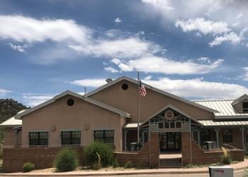
Balsam Glade Picnic Site
The surrounding forest and mountains provide a perfect backdrop for photography, flower walks, bird watching, hiking, relaxing and enjoying nature.
The group sheltered area must be reserved on Recreation.gov and is reservable from May 15 through October 15. The sheltered area is a replica of a mid-1930s Civilian Conservation Corps design, and can accomodate 30 people. There are picnic tables, grills and bear proof trash cans for your convenience.
Balsam Glade Picnic Site was named by an early American settler, who mistook the white fir that grows here, for balsam fir, as they are similar in appearance. He called this area “Balsam Glade” for so long that the name stuck.
From 1935 to 1941 the YMCA operated a summer camp for boys here. One young man who attended the camp as a youth, later became a counselor for boys at the “Y” camp. He was a fun loving fellow and gained the title “Ghost of the Sandia’s” for his wild antics, like flying over the campfire on a zip line and scaring the campers. The only evidence of the ‘Y’ camp are two sets of steps that led hundreds of hungry kids into the dining hall and out again to make more memories.
The Civilian Conservation Corps (CCC) has a rich history and lasting presence throughout the Sandia’s. In their honor, we ask that you take extra care to “Leave No Trace” when you visit.
- New Mexico Enchantment Pass (covers day-use fees for certain sites in five Natioanl Forests in New Mexico).
- Additional dispersed picnic areas, which do not require a reservation, are available on a first-come, first-served basis.
- No Camping Allowed
General Information
- New Mexico Enchantment Pass
- Interagency Passes
- Need help deciding which pass is right for you?
Day Use:
Group Picnic Site: $65 per day
- Requires a $5 fee or a day-use pass per vehicle.
- CASH OR CHECK ONLY at pay station.
- New Mexico Enchantment Pass
- Interagency Passes
Address: 11776 Hwy. 337, Tijeras, NM 87059
Phone: 505-281-3304
Hours: M-F: 8:00 a.m. - 4:30 p.m. (Closed on federal holidays)
Getting There
Latitude / Longitude
Latitude: 35.21355899
Longitude: -106.40857513
Elevation
8,660 ft
Directions
From I-40 and Exit 175, drive toward Cedar Crest on N-14. Follow N-14 aka the Turquoise Trail, for approximately 6.5 miles, to NM 536 aka the Sandia Crest Scenic Byway. Turn onto NM 536. Balsam Glade is approximately 7 miles up NM 536 (about one mile past the base of the Sandia Peak Ski area). Turn right into Balsam Glade Picnic Site.
(MVUM) Official Motor Vehicle Use Map - North
Living With Large Predators in New Mexico
About the Civilian Conservation Corps
If you choose to hike:
Please refer to the Sandia Mountain Trails map to plan your course.
- Cell phone coverage is not guaranteed.
- It is the recreationist’s responsibility to use a map.
- No Camping Allowed
- Trail(s) are open for the following uses: Hiking and Horseback Riding.
Facility and Amenity Information
Restrooms
Restrooms are available at this site.
Water
Potable water is not available at this site.
Picnic Tables
Picnic tables are available at this site.
Dispersed


