
Rock Crossing Trail No. 18
Nestled in Arizona’s Coconino National Forest southeast of Flagstaff, Rock Crossing Trail No. 18 offers hikers a serene 2.3-mile (one-way) journey through the lush landscapes of the Mogollon Rim near the C.C. Cragin (Blue Ridge) Reservoir. Divided into three segments (18A, 18B, and 18C) due to reservoir crossings, this trail provides a moderately easy hike with captivating scenery, diverse flora and fauna, and a taste of Arizona’s high-country charm. Crossings may be impassable during spring snowmelt or heavy rain, so make sure to check conditions and wear sturdy, quick-drying shoes.
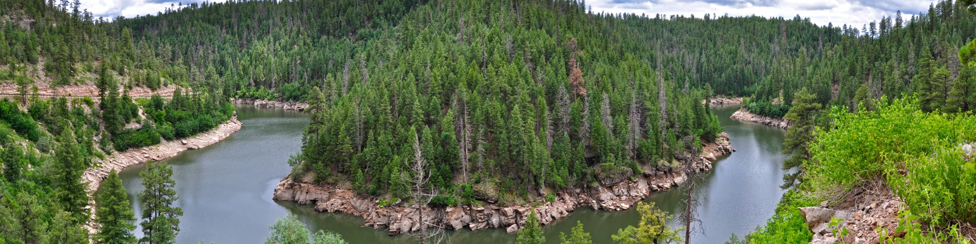
Hiking Rock Crossing Trail immerses you in the tranquil beauty of the Mogollon Rim. The trail begins at a trailhead off Forest Road 751, winding through fragrant ponderosa pine forests interspersed with oak and juniper. As you traverse segment 18A, a short, gradual descent brings you to the shimmering waters of the reservoir, where the glassy surface reflects surrounding trees and sky. Segments 18B and 18C skirt the reservoir’s edges, offering stunning vistas of its deep blue waters framed by rolling hills.
The trail’s varied terrain—smooth paths, occasional rocks, and roots—keeps the hike engaging. You’ll cross the reservoir twice (seasonal conditions permitting), which may involve shallow wading or navigating stepping stones, adding a touch of adventure. Along the way, open clearings provide spots to pause, picnic, or soak in the scenery. The final segment (18C) gently climbs to FR 139A, rewarding you with panoramic views of the forested landscape.
Specific Trail Information
Trail Number
Trail Type
General Information
- Difficulty: Moderate
- Trailhead Elevation: 7,149 ft.
- Elevation Gain/Loss: 331-338 ft.
- Length: Approximately 2.3 miles total. This trail is separated into three segments due to the necessity of its crossing C.C. Cragin Reservoir twice. See below...
- Trail 18A is a 0.4-mile segment that begins near Rock Crossing Campground and parallels Forest Road 751, gradually descending to the edge of the water for a 338-foot elevation drop. This is the most frequently used trail segment.
- Trail 18B is a 1.2-mile segment from the south edge of the upper arm of the reservoir to the north edge of the lower arm of the reservoir. A clearing for dispersed camping is at the south shore. This segment can be more challenging with some rocks, roots, and steep sections.
- Trail 18C is a 0.7-mile segment from the south edge of the lower arm of the reservoir to FR 139A. This has a 331-foot elevation gain.
Spring and fall offer mild weather and vibrant scenery; summer is warm but pleasant at this elevation. Winter hikes are possible but check for FR 751 closures and snow.
- Motor vehicles are not allowed on the trail.
- Dogs must always be on a leash, and owners must pick up after their pets. DO NOT leave bags of poop from your pets along the trail/trailhead for picking up later. If your pet defecates, you must bag the poop and take it with you. If you do not want to do this, do not bring your pet on trails.

Address: 8738 Ranger Road, Happy Jack, AZ 86024
Phone: 928-477-2255
Hours: Monday-Friday, 7 a.m. - 3:30 p.m. (Closed on federal holidays)
Office Email: SM.FS.Cof_Webmail@usda.gov
Getting There
Directions
Location: 1.5 hours drive southeast of Flagstaff on roads that are either paved or graveled and suitable for passenger cars in most weather.
Access: From Clints Well go north on Route 87 to Forest Road 751 (about 4 miles, approximate milepost 295.2) and turn right (southeast). Drive about 3.6 miles to the trailhead located on the right side of the road.
GPS (Map): 34°33'14.3"N 111°12'21.9"W